Interstate 20 in Alabama
| ||||
|---|---|---|---|---|
_map.svg.png) | ||||
| Route information | ||||
| Maintained by ALDOT | ||||
| Length: | 213 mi (343 km) | |||
| Major junctions | ||||
| West end: |
| |||
|
| ||||
| East end: |
| |||
| Highway system | ||||
| ||||
.svg.png)
In Alabama, Interstate 20 travels 214.7 miles[1] through the center of the state. It enters the state from Mississippi near Cuba, and travels northeastward through Tuscaloosa and Birmingham. At Birmingham, I-20 turns eastward and heads through Oxford before crossing the Georgia state line near Lebanon. Other cities on the route include Livingston, Bessemer, and Pell City.
For more than half its 130-mile (210 km) distance, I-20 overlaps Interstate 59 from the Mississippi border to eastern Birmingham near Birmingham International Airport. Mileage and exits on the concurrency are I-59's, although both routes have the same mileage for the Alabama duplex.
Route description
Western Alabama
After Interstate 20/59 enters Alabama from Mississippi, they travel concurrently northeastward across the Tombigbee River and Black Warrior River delta country which is generally low-lying farmland until reaching Tuscaloosa. This area contains low population. US Highway 11 parallels this route from Mississippi northeastward while it passes through small towns like York, Livingston, and Eutaw before reaching Tuscaloosa.
At Tuscaloosa, the route connects with the spur interstate Interstate 359 which travels northward into downtown Tuscaloosa and to the University of Alabama.
From the Mississippi/Alabama state line to Tuscaloosa, Interstate 20/59 is a four-lane route. While passing Tuscaloosa, the route briefly becomes six lanes but once again becomes four lanes east of exit 73.
From Tuscaloosa to Birmingham, the route continues on an east/northeast heading traveling through rolling forested terrain until reaching Interstate 459 southwest of Bessemer. Most of this stretch is now a six-lane freeway and construction continues to widen the route just northeast of Tuscaloosa to six-lane capacity. This stretch also hosts the Mercedes auto plant which is a large employer of residents primarily from Jefferson, Tuscaloosa, and Bibb counties. Interstate 459 travels east and then northeast around the southern periphery of the Birmingham area before re-connecting first with Interstate 20 near Irondale and then terminating at Interstate 59 near Trussville. The Birmingham Northern Beltline Corridor X-1, which is slated to become Interstate 422, is to connect to I-20/59 at the Interstate 459 interchange; however, this project is still years away from completion.
Birmingham
After passing the Interstate 459 interchange, the route continues northeast through the Birmingham suburbs of Bessemer, Fairfield, and Hueytown and entering Birmingham near the Ensley community. The route continues east/northeast through downtown before reaching the Birmingham-Shuttlesworth International Airport where Interstate 59 continues northeast toward Gadsden and Interstate 20 turns eastward toward Atlanta. Most of this stretch is through urban areas including passing near the U.S. Steel plant near Fairfield. Near Fairfield and visible from the Interstate looking north and northwest are several smokestacks which is all that remain of several large steelmills that used to dominate the Ensley community of Birmingham.
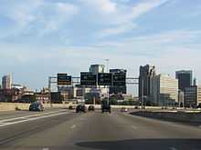
As Interstate 20/59 travels eastward just past the Arkadelphia Road exit in the East Thomas community, the highway rises to the top of East Thomas hill, giving eastbound travelers an excellent view of the downtown Birmingham skyline just before reaching the interchange with Interstate 65. This interchange is known locally as "Malfunction Junction" due to the fact that the eastbound and westbound lanes briefly cross each other and the route has exit ramps for Interstate 65 on both sides of the road which can cause confusion and accidents.
As Interstate 20/59 leaves the downtown area, the route has an interchange with the Elton Stephens Expressway, also known locally as the Red Mountain Expressway, which travels south across the downtown area and into the southern Birmingham suburbs.
Once Interstate 20 turns away from Interstate 59, it begins an eastbound journey toward Georgia. The first two miles are a four-lane bridge of east Birmingham neighborhoods before reaching the shopping areas formerly known as Eastwood Mall and Century Plaza Mall. Eastwood Mall at its opening was the largest shopping mall in the Southeast while Century Plaza Mall was the first two-level shopping mall in Birmingham. Eastwood Mall was razed in 2006 and in its places exists a Wal-Mart Supercenter and other retailers. Century Plaza closed in June 2009 and the future of the site is still in question.
Interstate 20 is a six-lane freeway from exit 132 to exit 147. This route travels through rolling suburban country and crosses Interstate 459 near Irondale.
"Bloody 20"
East of exit 147, Interstate 20 once again becomes a four-lane route until mile marker 155. This eight-mile stretch is arguably the most dangerous stretch of interstate highway in Alabama. The terrain is significantly hilly as the route passing across the northeast to southwest ridges of the Appalachian Mountains. There are two significant uphill grades in each direction which slows down truck traffic. The posted speed limit in this eight-mile stretch is 55 mph. However, due to the heavy volume of truck traffic combined with speeding car traffic, accidents are frequent and sometimes deadly. This part of Interstate 20 is sometimes called "Bloody 20". There are plans by the Alabama Department of Transportation to widen this stretch to six lanes, and according to The Birmingham News on July 31, 2009, bids were placed to widen the eight miles of mountainous terrain. A concrete median has already been installed in this stretch, but once construction began in 2012 to widen the road, closings and delays became common as significant blasting of rock formations was required. US 78 can be used as a detour during times of accidents between exit 147 and exit 153, but US 78 travels concurrently with Interstate 20 between exits 153 and 156 and no parallel alternate route is available in this hilly area.
Eastern Alabama
East of mile marker 155, the route once again becomes six lanes until reaching the Coosa River bridge near Riverside. This bridge is scheduled to be replaced when the stretch between the Coosa River and mile marker 172 is widened to six lanes from four lanes. However, no timetable for this project has been announced. Exits 165 and 168 serve the Honda Motor Company which has a plant at Lincoln. Exits 168 and 173 serve the Talladega Superspeedway which hosts two NASCAR racing weeks each year. The terrain east of mile marker 155 until reaching mile marker 191 is the relatively flat Coosa River valley.
East of mile marker 172 until mile marker 178, the route is once again six lanes. East of mile marker 178 until mile marker 182, construction to widen the route to six lanes is underway; completion was to be scheduled before the end of 2009, but the project extended into 2012 and extended another mile, narrowed to two lanes due to the road work until it reaches Anniston. East of this area, Interstate 20 remains a four-lane route until it reaches the Georgia state line (mile marker 215). The Anniston/Oxford area is served by exits 179, 185, 188, and 191.
Just east of exit 191 is a significant uphill/downhill grade (uphill eastbound/downhill westbound) approximately two miles long. Truck traffic is significantly slowed by this hill, causing occasional traffic backups. East of this incline, the route travels through generally rural forested rolling country until reaching the Georgia state line.
East of Birmingham, U.S. Route 78 serves as the parallel U.S. highway.
History
Between Leeds and Riverside in the early 1960s. Between the Jefferson/Tuscaloosa county line and Tuscaloosa (exit 73) in the mid-1960s. Between Arkadelphia Road and Ensley Avenue (Birmingham) in the late 1960s. A short segment from the Mississippi/Alabama border to Cuba, Alabama.
Early 1970s: between exit 73 and Epes, Alabama. between Riverside (exit 162) and Lincoln (exit 168), then to Anniston/Oxford (exit 185). Between Arkadelphia Road and downtown Birmingham. Between Ensley Avenue and Valley Road in Fairfield.
Mid-1970s: From 17th Street in downtown Birmingham to U.S. Route 78 in Irondale. From Valley Road in Fairfield to 18th Street in Bessemer. From exit 185 to exit 199 at Heflin, Alabama.
Late 1970s and early 1980s: From Exit 199 to Exit 205 (Heflin, Alabama). The remainder of the route eastbound to the Georgia line was complete, but officials waited for Georgia to complete the section from Douglasville westward to the Alabama line before it could be opened.
From US 78 in Irondale to Leeds. From Epes, Alabama to Livingston, Alabama and then from Livingston to Cuba, Alabama.
By the mid-1980s the entire route was complete and open to traffic. Interstate 20 has no three-digit spur routes in Alabama, although at one time there was discussion of a spur northward from Oxford into Anniston which would also serve as a connection to the U.S. Army base at Fort McClellan as well as to Gadsden. The closing of the base as well as a lack of population between Anniston and Gadsden eliminated the necessity of such a route.
In Alabama's 1962 Democratic primary run-off, George Wallace carried every county except Jefferson County, the most populous in the state. Wallace vowed to prevent any state highway funding to allow the completion of Interstate 20's Jefferson County segment, a promise he fulfilled, thus hastening Atlanta's rise to pre-eminence among Southern cities.
Exit list
| County | Location | mi | km | Exit | Destinations | Notes |
|---|---|---|---|---|---|---|
| Sumter | Continuation into Mississippi | |||||
| 1 | ||||||
| 8 | ||||||
| 17 | ||||||
| 23 | ||||||
| Greene | 32 | Boligee | ||||
| 40 | ||||||
| 45 | Union | |||||
| 52 | ||||||
| Tuscaloosa | 62 | Fosters | ||||
| Tuscaloosa | 68 | Northport Tuscaloosa Western Bypass | ||||
| 71 | Signed as exits 71A (south) and 71B (north), I-359 south exit 0, north exits 0A-B | |||||
| 73 | ||||||
| 76 | ||||||
| 77 | Cottondale | |||||
| 79 | ||||||
| 86 | Brookwood, Vance | |||||
| 89 | Mercedes Drive | |||||
| 97 | South end of US-11 / SR-5 overlap | |||||
| 100 | Abernant, Bucksville | Unsigned eastern terminus for SR-216 | ||||
| Jefferson | 104 | Rock Mountain Lake | McAshan Drive | |||
| 106 | I-459 exit 0 | |||||
| Bessemer | 108 | North end of US-11 / SR-5 overlap | ||||
| 110 | Alabama Adventure Parkway | |||||
| 112 | 18th Street, 19th Street | |||||
| 113 | 18th Avenue | |||||
| 115 | Allison–Bonnet Memorial Drive, Jaybird Road | |||||
| Fairfield | 118 | Valley Road – Fairfield | ||||
| Birmingham | 119 | Lloyd Nolan Parkway | Signed as exit 119A southbound | |||
| 119B | Avenue I | Southbound exit and northbound entrance | ||||
| 120 | ||||||
| 121 | Bush Boulevard | Southbound exit and northbound entrance | ||||
| 123 | ||||||
| 124 | Signed as exits 124A (south) and 124B (north); I-65 exits 261A-B | |||||
| 125A | 17th Street – Downtown Birmingham | Northbound exit and southbound entrance | ||||
| 125B | 22nd Street – Downtown Birmingham | Signed as exit 125 southbound | ||||
| 126A | ||||||
| 126B | 31st Street North | |||||
| 128 | ||||||
| 129 | Airport Boulevard | |||||
| 130A | Eastern end of I-59 overlap | |||||
| 130B | Signed as exits 130A (south) and 130B (north) eastbound | |||||
| 132A | Eastbound exit and westbound entrance | |||||
| 132B | Signed as exit 132 westbound | |||||
| Irondale | 133 | |||||
| 135 | ||||||
| 136 | I-459 exit 29 | |||||
| Leeds | 140 | |||||
| St. Clair | 144 | Signed as exits 144A (south) and 144B (north) | ||||
| Moody | 147 | Brompton | ||||
| 152 | Cook Springs | |||||
| 153 | Western end of US-78/SR-4 overlap | |||||
| Pell City | 156 | Eastern end of US-78/SR-4 overlap | ||||
| 158 | ||||||
| Riverside | 162 | |||||
| Coosa River (Logan Martin Lake) | Bridge over the Coosa River | |||||
| Talladega | Lincoln | 165 | Embry, Lincoln | |||
| 168 | ||||||
| 173 | Eastaboga | |||||
| Oxford | 179 | |||||
| Calhoun | 185 | |||||
| Anniston | 188 | |||||
| 191 | ||||||
| Cleburne | 199 | |||||
| 205 | ||||||
| Tallapoosa River | Bridge over the Tallapoosa River | |||||
| 210 | Ranburne, Muscadine | |||||
| Continuation into Georgia | ||||||
1.000 mi = 1.609 km; 1.000 km = 0.621 mi
| ||||||
References
- ↑ FHWA Route Log and Finder List U.S. Department of Transportation - Federal Highway Administration (2002). Accessed May 3, 2007.
External links
Route map: Bing
| Wikimedia Commons has media related to Interstate 20 in Alabama. |
- SouthEastRoads-Interstate 20
- SouthEastRoads-Interstates 20 East/59 North
- SouthEastRoads-Interstates 20 West/59 South
| Previous state: Mississippi |
Alabama | Next state: Georgia |
| ||||||||||