Inishmurray
| Native name: <span class="nickname" ">Inis Muireadheach | |
|---|---|
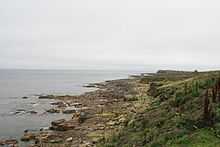 Southern coast line of Inishmurray | |
 | |
| Geography | |
| Location | Atlantic Ocean |
| Coordinates | 54°26′N 8°40′W / 54.433°N 8.667°WCoordinates: 54°26′N 8°40′W / 54.433°N 8.667°W |
| Area | 0.9 km2 (0.35 sq mi) |
| Country | |
| Province | Connacht |
| County | Sligo |
| Demographics | |
| Population | 0 (as of 2011) |
Inishmurray (Irish: Inis Muireadheach, meaning "Muireadheach's island") is an uninhabited island situated 7 km off the coast of County Sligo, Ireland. It covers 228 acres (0.9 km2). The island may be named after the early saint, Muiredach mac Echdach (fl. early 6th century) of Killala. There are remains of an early Irish monastic settlement. Laisrén (Saint Molaise) Mac Decláin reputedly founded a monastery here in the 6th century. He was confessor of Saint Columba after the Battle of Cúl Dreimhne on the mainland nearby. His feast day is the 12 August.
The island's ecclesiastical settlement was attacked in 807 by the Vikings.[1]
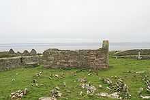
Monastery
The enclosure wall is impressive - reaching 15 feet (4.6 m) in height at its highest point and up to 10 feet (3.0 m) thick.[2] The site contains various ecclesiastical buildings including enclosures, a stone-roofed oratory, two churches, a clochan, a large beehive-shaped cell, a holy well and other remains including cross slabs suggesting foreign influences. The whole complex is composed of what is probably local limestone rubble.
Recent history
The local population peaked at just over 100 in the 1880s but the last residents moved out to the mainland on 12 November 1948. Some of the buildings are still visible including 15 houses and the island's school.
The site remained a pilgrimage destination right up to recent times.
See also
- List of abbeys and priories in Ireland (County Sligo)
Literature
- Aubrey Gwynn and R. N. Hadcock: Medieval Religious Houses Ireland. Longman, London, 1970, ISBN 0-582-11229-X.
- Patrick Heraughty: Inishmurray: Ancient Monastic Island. O'Brien, Dublin, 1982, ISBN 0-86278-473-5.
- Joe McGowan: Inishmurray: Island Voices, Aeolus Publications, 2004, ISBN 0-9521334-3-1.
- John Haywood: The Historical Atlas of the Celtic World, Thames & Hudson, 2009, ISBN 978-0-500-28831-3.
- H.Th. De Booy: Het spook van Inish Murray (Ghost at Inishmurray - fiction). Deltos Elsevier, Amsterdam/Brussel 1971, ISBN 978-9-010-05509-5.
Other projects
![]() Media related to Inishmurray at Wikimedia Commons
Media related to Inishmurray at Wikimedia Commons