Infanta, Pangasinan
| Infanta | ||
|---|---|---|
| Municipality | ||
 | ||
| ||
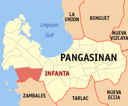 Map of Pangasinan showing the location of Infanta | ||
.svg.png) Infanta Location within the Philippines | ||
| Coordinates: 15°49′N 119°54′E / 15.817°N 119.900°ECoordinates: 15°49′N 119°54′E / 15.817°N 119.900°E | ||
| Country |
| |
| Region | Ilocos (Region I) | |
| Province | Pangasinan | |
| District | 1st district of Pangasinan | |
| Founded | October 4,1876 | |
| Barangays | 13 | |
| Government[1] | ||
| • Mayor | Percival Almario Mallare | |
| Area[2] | ||
| • Total | 254.29 km2 (98.18 sq mi) | |
| Population (2010)[3] | ||
| • Total | 23,455 | |
| • Density | 92/km2 (240/sq mi) | |
| Time zone | PST (UTC+8) | |
| ZIP code | 2412 | |
| Dialing code | 75 | |
| Income class | 3rd class; rural | |
| Website |
www | |

Infanta is a third class municipality in the province of Pangasinan, Philippines. According to the 2010 census, it has a population of 23,455 people.[3]
Barangays
Infanta is politically subdivided into 13 barangays.[2]
- Bamban
- Batang
- Bayambang
- Cato
- Doliman
- Patima
- Maya
- Nangalisan
- Nayom
- Pita
- Poblacion
- Potol
- Babuyan
Demographics
| Population census of Infanta | ||
|---|---|---|
| Year | Pop. | ±% p.a. |
| 1990 | 16,149 | — |
| 1995 | 18,839 | +2.93% |
| 2000 | 20,632 | +1.97% |
| 2007 | 23,731 | +1.95% |
| 2010 | 23,455 | −0.42% |
| Source: National Statistics Office[3][4] | ||

Infanta Town Hall
References
- ↑ "Official City/Municipal 2013 Election Results". Intramuros, Manila, Philippines: Commission on Elections (COMELEC). 1 July 2013. Retrieved 5 September 2013.
- ↑ 2.0 2.1 "Province: PANGASINAN". PSGC Interactive. Makati City, Philippines: National Statistical Coordination Board. Retrieved 26 November 2012.
- ↑ 3.0 3.1 3.2 "Total Population by Province, City, Municipality and Barangay: as of May 1, 2010". 2010 Census of Population and Housing. National Statistics Office. Retrieved 26 November 2012.
- ↑ "Province of Pangasinan". Municipality Population Data. LWUA Research Division. Retrieved 5 September 2013.
External links
| Wikimedia Commons has media related to Infanta, Pangasinan. |
- Philippine Standard Geographic Code
- Philippine Census Information
- Local Governance Performance Management System
 |
Dasol Bay | Dasol, Mabini | | |
| South China Sea | |
Bugallon | ||
| ||||
| | ||||
| Santa Cruz, Zambales |
| ||||||||||||||||||||||