Indiana State Road 450
| ||||
|---|---|---|---|---|
 | ||||
| Route information | ||||
| Maintained by INDOT | ||||
| Length: | 26.6 mi[1] (42.8 km) | |||
| Major junctions | ||||
| West end: |
| |||
| East end: |
| |||
| Location | ||||
| Counties: | Martin, Lawrence | |||
| Highway system | ||||
| ||||

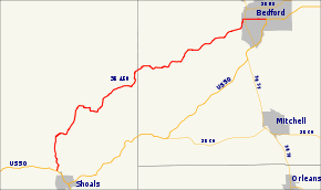
State Road 450 is a winding route in southern Indiana that terminates at both ends at its parent route, U.S. Route 50. It covers a distance of about 25 miles (40 km).
Route description
State Road 450 begins just north of the town of Shoals in Martin County and runs northeast to rejoin U.S. Route 50 in downtown Bedford in Lawrence County.
Major intersections
| County | Location | mi[1] | km | Destinations | Notes |
|---|---|---|---|---|---|
| Martin | Shoals | 0.00 | 0.00 | Western Terminus of SR 450 | |
| Lawrence | Bedford | 24.88 | 40.04 | Eastern terminus of SR 158 | |
| 25.07 | 40.35 | Western end of US 50 concurrency | |||
| 26.60 | 42.81 | Eastern end of US 50 concurrency; Eastern terminus of SR 450 | |||
1.000 mi = 1.609 km; 1.000 km = 0.621 mi
| |||||
References
- ↑ 1.0 1.1 "INDOT Roadway Referencing System" (PDF).