Indiana State Road 352
| ||||
|---|---|---|---|---|
 | ||||
| Route information | ||||
| Maintained by INDOT | ||||
| Length: | 20.56 mi[1] (33.09 km) | |||
| Major junctions | ||||
| West end: |
| |||
|
| ||||
| East end: |
| |||
| Location | ||||
| Counties: | Benton, Warren | |||
| Highway system | ||||
| ||||

State Road 352 in the U.S. state of Indiana is an east–west state highway in Benton County and Warren County in the west-central part of the state.
Route description
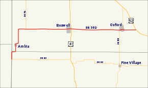
The western terminus of State Road 352 is at the Illinois border where State Road 26 and Illinois Route 9 meet. It first winds north for about four miles (6 km), making two half-mile jogs to the east and passing through the small town of Ambia. It then proceeds directly east, passing the southern terminus of State Road 71 after one mile (1.6 km). Six miles further to the east, it passes through the town of Boswell and crosses U.S. Route 41. After another seven miles (11 km), it passes through the town of Oxford, where it crosses State Road 55. The eastern terminus is at U.S. Route 52, about a mile and a half east of Oxford.
Major intersections
| County | Location | mi[1] | km | Destinations | Notes |
|---|---|---|---|---|---|
| Warren | Prairie Township | 0.00 | 0.00 | Western terminus of SR 352; western terminus of SR 26; eastern terminus of IL 9 | |
| Benton | Hickory Grove Township | 5.78 | 9.30 | Southern terminus of SR 71 | |
| Boswell | 11.85 | 19.07 | |||
| Oxford | 18.21 | 29.31 | Western end of SR 55 concurrency | ||
| 18.76 | 30.19 | Eastern end of SR 55 concurrency | |||
| Oak Grove Township | 20.56 | 33.09 | Eastern terminus of SR 352 | ||
1.000 mi = 1.609 km; 1.000 km = 0.621 mi
| |||||
References
- ↑ 1.0 1.1 "INDOT Roadway Referencing System" (PDF).
External links
Route map: Bing