Indiana State Road 258
| ||||
|---|---|---|---|---|
 | ||||
| Route information | ||||
| Maintained by INDOT | ||||
| Length: | 12.83 mi[1] (20.65 km) | |||
| Major junctions | ||||
| West end: |
| |||
| East end: |
| |||
| Location | ||||
| Counties: | Jackson | |||
| Highway system | ||||
| ||||

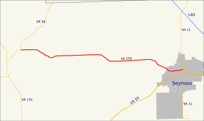
State Road 258 is a short undivided two-lane road in Jackson County in the southern part of the U.S. state of Indiana.
Route description
State Road 258 begins at State Road 58 about a mile northeast of the small town of Freetown. From here, it runs east to State Road 11 in Seymour, a distance of approximately 13 miles (21 km). State Road 258 runs east from Freetown, while its parent route State Road 58 angles to the northeast on its way to the Columbus area.
Major intersections
The entire route is in Jackson County.
| Location | mi[1] | km | Destinations | Notes | |
|---|---|---|---|---|---|
| Pershing Township | 0.00 | 0.00 | Western terminus of SR 258 | ||
| Seymour | 12.83 | 20.65 | Eastern terminus of SR 258 | ||
| 1.000 mi = 1.609 km; 1.000 km = 0.621 mi | |||||
History
The Bell Ford Bridge was located next to State Road 258 until it collapsed in 2006.
References
- ↑ 1.0 1.1 "INDOT Roadway Referencing System" (PDF).
External links
Route map: Bing