Indiana State Road 167
| ||||
|---|---|---|---|---|
 | ||||
| Route information | ||||
| Maintained by INDOT | ||||
| Length: | 10.45 mi[1] (16.82 km) | |||
| Major junctions | ||||
| South end: |
| |||
| North end: |
| |||
| Location | ||||
| Counties: | Blackford, Delaware, Jay | |||
| Highway system | ||||
| ||||

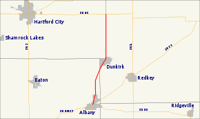
State Road 167 (SR 167) is a part of the Indiana State Road that runs between Albany and Trenton in US state of Indiana. The 10.45 miles (16.82 km) of SR 167 that lie within Indiana serve as a minor highway. None of the highway is listed on the National Highway System. The entire route is rural two-lane highway that passes through farmland and residential properties.
Route description
SR 167 begins in Albany in Delaware County at its parent route, SR 67. The route heads northeast, passing through rural farmland as a two-lane highway. The road passes through Dunkirk concurrent with Main Street. After Dunkirk the road turns due north along the border between Blackford and Jay Counties. The highway ends at an intersection with SR 26 east of Hartford City.[2][3]
No segment of State Road 167 in Indiana is included in the National Highway System (NHS).[4] The NHS is a network of highways that are identified as being most important for the economy, mobility and defense of the nation.[5] The highway is maintained by the Indiana Department of Transportation (INDOT) like all other state roads in the state. The department tracks the traffic volumes along all state roads as a part of its maintenance responsibilities using a metric called average annual daily traffic (AADT). This measurement is a calculation of the traffic level along a segment of roadway for any average day of the year. In 2010, INDOT figured that lowest traffic levels were 840 vehicles and 130 commercial vehicles used the highway daily near its northern terminus. The peak traffic volumes were 3,0901 vehicles and 250 commercial vehicles AADT along the section of SR 167 near its southern terminus.[6]
Major intersections
| County | Location | mi[1] | km | Destinations | Notes |
|---|---|---|---|---|---|
| Delaware | Albany | 0.00 | 0.00 | Southern terminus of SR 167 | |
| Blackford – Jay | Jackson Township – Knox Township | 10.45 | 16.82 | Northern terminus of SR 167 | |
| 1.000 mi = 1.609 km; 1.000 km = 0.621 mi | |||||
References
- ↑ 1.0 1.1 Staff (2004). "Reference Post Book" (PDF). Indianapolis: Indiana Department of Transportation. Retrieved November 16, 2012.
- ↑ Indiana Department of Transportation (2012). Indiana Transportation Map (PDF) (Map) (2011–2012 ed.). Indianapolis: Indiana Department of Transportation. § F9. Retrieved November 16, 2012.
- ↑ Google (November 16, 2012). "Indiana State Road 167" (Map). Google Maps. Google. Retrieved November 16, 2012.
- ↑ Federal Highway Administration (December 2003). National Highway System: Indiana (PDF) (Map). Washington, DC: Federal Highway Administration. Retrieved November 16, 2012.
- ↑ Natzke, Stefan; Neathery, Mike; Adderly, Kevin (September 26, 2012). "What is the National Highway System?". National Highway System. Federal Highway Administration. Retrieved November 16, 2012.
- ↑ Staff (2010). "Indiana Traffic Counts". Indianapolis: Indiana Department of Transportation. Retrieved November 16, 2012.
External links
Route map: Bing