Indiana State Road 144
| ||||
|---|---|---|---|---|
 | ||||
| Route information | ||||
| Maintained by INDOT | ||||
| Length: | 12.97 mi (20.87 km) | |||
| Western section | ||||
| Length: | 7.17 mi (11.54 km) | |||
| West end: |
| |||
| East end: |
| |||
| Eastern section | ||||
| Length: | 5.80 mi (9.33 km) | |||
| West end: |
| |||
| East end: |
| |||
| Location | ||||
| Counties: | Morgan, Johnson | |||
| Highway system | ||||
| ||||

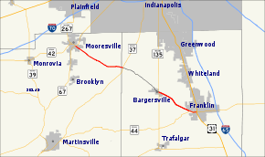
State Road 144 in the U.S. State of Indiana is a highway that exists in two short sections south of Indianapolis.
Route description
State Road 144 runs from its northwest end at the southern terminus of Indiana State Road 267 and the eastern terminus of Indiana State Road 42 in Mooresville southeast to its parent route, Indiana State Road 44, in Franklin.
History
The middle one-third of its run, from Indiana State Road 37 near the Morgan/Johnson County line in the west to Indiana State Road 135 in Old Bargersville, Indiana, in the east, was downgraded to county road status in early 2005. It is one of the very few county roads in Indiana with a numerical designation identical to that of an adjoining state road, similar to how it is done in Florida.
Major intersections
| County | Location | mi[1] | km | Destinations | Notes | ||
|---|---|---|---|---|---|---|---|
| Morgan | Mooresville | 0.00 | 0.00 | Western terminus of SR 144 | |||
| Johnson | White River Township | 7.17 | 11.54 | Eastern terminus of the western section of SR 144 | |||
| Gap in route | |||||||
| Bargersville | 7.17 | 11.54 | Western terminus of the eastern section of SR 144 | ||||
| Franklin | 11.94 | 19.22 | Eastern terminus of the western section of SR 44;[2] Eastern terminus of SR 144; Route continues as West Jefferson Street | ||||
| 12.97 | 20.87 | ||||||
| 1.000 mi = 1.609 km; 1.000 km = 0.621 mi | |||||||
References
- ↑ "INDOT Roadway Referencing System" (PDF).
- ↑ "Franklin takes control of highway through city" (WEB).
External links
Route map: Bing