Inasa, Shizuoka
| Inasa 引佐町 | |
|---|---|
| Former municipality | |
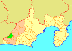 Location of Inasa in Shizuoka Prefecture | |
 Inasa Location in Japan | |
| Coordinates: 34°49′07″N 137°40′43″E / 34.81861°N 137.67861°ECoordinates: 34°49′07″N 137°40′43″E / 34.81861°N 137.67861°E | |
| Country | Japan |
| Region | Chūbu (Tōkai) |
| Prefecture | Shizuoka Prefecture |
| District | Inasa |
| Merged |
July 1, 2005 (now part of Kita-ku, Hamamatsu) |
| Area | |
| • Total | 121.18 km2 (46.79 sq mi) |
| Population (April 1, 2005) | |
| • Total | 14,481 |
| • Density | 119.5/km2 (310/sq mi) |
| Time zone | Japan Standard Time (UTC+9) |
| Symbols | |
| - Tree | Japanese cypress |
| - Flower | Azalea |
Inasa (引佐町 Inasa-chō) was a town located in Inasa District, Shizuoka Prefecture, Japan. Inasa became a town on May 1, 1955.
As of April 1, 2005, the town had an estimated population of 14,481 and a density of 119.5 persons per km². The total area was 121.18 km².
On July 1, 2005, Inasa, along with the cities of Tenryū and Hamakita, the town of Haruno (from Shūchi District), the towns of Hosoe and Mikkabi (all from Inasa District), the towns of Misakubo and Sakuma, the village of Tatsuyama (all from Iwata District), and the towns of Maisaka and Yūtō (both from Hamana District), was merged into the expanded city of Hamamatsu, and is now part of Kita-ku, Hamamatsu City.
Sister cities
Inasa formerly was a sister city with Chehalis, Washington, in the United States of America.