Inagi, Tokyo
| Inagi 稲城市 | ||
|---|---|---|
| City | ||
|
Clockwise from top left: Yomiuri Land Amusement Park, Aoi Shrine, Stone Buddha Statue in Mount Arigata, Anazawa-ten Shrine, Inagi Central Park, Inagi Bridge | ||
| ||
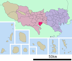 Location of Inagi in Tokyo Metropolis | ||
 Inagi Location in Japan | ||
| Coordinates: 35°18′17″N 139°30′17″E / 35.30472°N 139.50472°ECoordinates: 35°18′17″N 139°30′17″E / 35.30472°N 139.50472°E | ||
| Country | Japan | |
| Region | Kantō | |
| Prefecture | Tokyo Metropolis | |
| Government | ||
| • Mayor | Ryoichi Ishikawa | |
| Area | ||
| • Total | 17.97 km2 (6.94 sq mi) | |
| Population (2008) | ||
| • Total | 81,134 | |
| • Density | 4,096/km2 (10,610/sq mi) | |
| Time zone | Japan Standard Time (UTC+9) | |
| Website |
www | |


Inagi (稲城市 Inagi-shi) is a city located in Tokyo Metropolis, Japan. The city was founded on November 1, 1971.
As of 2008, the city has an estimated population of 81,134 and a population density of 4,096.33 persons per km². The total area is 17.97 km².
History
Inagi as a municipality was founded on April 1, 1889 as Inagi Village in what was then the Minamitama District from the merger of 6 pre-Meiji period villages.
On April 1, 1957, Inagi Village was reclassified as Inagi Town.
On November 1, 1971, Inagi Town was reclassified as Inagi City, dissolving Minamitama District. Inagi with Tama was the last town within the former Minamitama District.
Politics and government
Inagi is run by a city assembly with 22 elected members. The current mayor is Ryoichi Ishikawa, an independent.
Elections
Education
Inagi operates public elementary and junior high schools.
Tokyo Metropolitan Government Board of Education operates Wakaba Sogo High School.[1]
References
External links
| Wikimedia Commons has media related to Inagi, Tokyo. |
- Inagi City official website (Japanese)
| ||||||||||||||||||||||||||