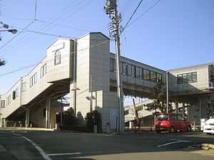
Ina Station
Ina Station 伊奈駅 | |
 | |
|---|---|
| Entrance | |
| Location | |
| Prefecture | Aichi (See other stations in Aichi) |
| City | Toyokawa |
| Neighborhood etc. | Ina-cho, Minamiyama Shinden 292-1 |
| Postal code | 441-0105 |
| (in Japanese) | 愛知県豊川市伊奈町南山新田292番地1 [1] |
| History | |
| Opened | 1927 [2] |
| Rail services | |
| Operator(s) | Nagoya Railroad |
| Line(s) | Meitetsu Nagoya Main Line |
| Statistics | 524,404 [3] passengers/year 2006 |
.jpg)
Ticket Gate
Ina Station (伊奈駅 Ina-eki) is a railway station on the Meitetsu Nagoya Main Line located in Toyokawa, Aichi, Japan. It is located 5.0 kilometers from the junction of the Nagoya Main Line at Toyohashi.
History
Ina Station was opened on September 1, 1923 as a station on the Aichi Electric Railway. On April 1, 1935, the Aichi Electric Railway merged with the Nagoya Railroad (the forerunner of present-day Meitetsu). A new station building was completed in March 1996.
Lines
- Nagoya Railroad
Layout
Ina Station is an elevated station, with one side platform and one island platform.
Platforms
| 2 | ■Meitetsu Nagoya Main Line | For Higashi Okazaki, Meitetsu Nagoya and Inuyama |
| 3 | ■Meitetsu Nagoya Main Line | For Toyohashi |
| 4 | ■Meitetsu Nagoya Main Line | For Higashi Okazaki, Meitetsu Nagoya and Inuyama |
Adjacent stations
| « | Service | » | ||
|---|---|---|---|---|
| Meitetsu Nagoya Main Line | ||||
| Toyohashi | Raipid Limited Express (快速特急)(Partially) | Kō | ||
| Toyohashi | Limited Express (特急)(Partially) | Kō | ||
| Toyohashi | Express (急行) | Kō | ||
| Terminus | Semi Express (準急) | Kō | ||
| Terminus | Local (普通) | Odabuchi | ||
See also
-
 Media related to Ina Station at Wikimedia Commons
External links
- (Japanese) Meitetsu Station information
References
- ↑ 伊奈 [Ina] (in Japanese). Nagoya Railroad. 1 April 2010. Retrieved 10 December 2010.
- ↑ 鷲田, 鉄也 (October 2010), "週刊歴史でめぐる鉄道全路線 大手私鉄", 週刊朝日百科 (Japan: Asahi Shimbun Publications, Inc.) (08): 21, ISBN 978-4-02-340138-9
- ↑ 第10章 運輸・通信 (平成20年度刊愛知県統計年鑑) [Statistics of Aichi in Year 20 of the Heisei Era] (in Japanese). Aichi Prefecture. 2008. Retrieved 30 November 2010.
| ||||||
Coordinates: 34°48′09″N 137°21′18″E / 34.80250°N 137.35500°E