Imphal
| Imphal City ইম্ফল | |
|---|---|
| Capital city of Manipur | |
 Imphal City | |
| Coordinates: 24°49′N 93°57′E / 24.82°N 93.95°ECoordinates: 24°49′N 93°57′E / 24.82°N 93.95°E | |
| Country | India |
| State | Manipur |
| District | Imphal West, Imphal East |
| Elevation | 786 m (2,579 ft) |
| Population (2011 census) | |
| • Total | 264,986 (City), 414,288 (Metropolitan area)[1] |
| Languages | |
| • Official | Meiteilon (Manipuri) |
| Time zone | IST (UTC+5:30) |
| PIN | 795xxx |
| Telephone code | 3852 |
| Vehicle registration | MN01 |
| Website |
www |
The city of Imphal (/ˈɪmpəl/, ![]() Imphal.ogg ) is the capital of the Indian state of Manipur. The ruins of the Palace of Kangla, the royal seat of the erstwhile Kingdom of Manipur, are in the city centre, surrounded by a moat.
Imphal.ogg ) is the capital of the Indian state of Manipur. The ruins of the Palace of Kangla, the royal seat of the erstwhile Kingdom of Manipur, are in the city centre, surrounded by a moat.
History
Early history
Originally ruled by King Khaba, the throne of Imphal was later ceded by the Pakhangba leaders. It was here that the Ningthouja dynasty originated. The Ningthouja people expanded their influence in politics and warfare. The Kangla Palace, built by King Khagemba and his son Khunjaoba, was destroyed by the British during the Anglo-Manipuri War. During the reign of Maharaja Bhagyachandra, the region experienced several Burmese invasions; however, with the help of Gambhir Singh and the Manipur army, Kangla was liberated from the Burmese forces.
British rule
The region remained peaceful until British officials arrived in 1891. Taking advantage of internal differences among the royal family, the British sent J. W. Quinton to negotiate. The situation worsened; Senapati Tikendrajit was banished from the capital, which led to the first Anglo-Manipur war. Britain's undeclared rule over Manipur angered the local population. In 1892, the second Anglo-Manipur war broke out between the British and forces led by the Manipuri commander-in-chief. The British attacked the palace, and gunned down the walls of Kangal Fort. After its capture, Manipur remained a part of British India until independence in 1947.
Geography and climate
| Imphal | ||||||||||||||||||||||||||||||||||||||||||||||||||||||||||||
|---|---|---|---|---|---|---|---|---|---|---|---|---|---|---|---|---|---|---|---|---|---|---|---|---|---|---|---|---|---|---|---|---|---|---|---|---|---|---|---|---|---|---|---|---|---|---|---|---|---|---|---|---|---|---|---|---|---|---|---|---|
| Climate chart (explanation) | ||||||||||||||||||||||||||||||||||||||||||||||||||||||||||||
| ||||||||||||||||||||||||||||||||||||||||||||||||||||||||||||
| ||||||||||||||||||||||||||||||||||||||||||||||||||||||||||||
Imphal is located at 24°49′N 93°57′E / 24.82°N 93.95°E in extreme eastern India,[3] with an average elevation of 786 metres (2,579 ft). It has a humid subtropical climate (Köppen Cwa)[4] with mild, dry winters and a hot monsoon season. July temperatures average about 29 °C (84 °F); January is the coldest month, with average lows near 4 °C (39 °F). The city receives about 1,320 mm (52 in) of rain, with June the wettest month. The highest recorded temperature was 35.6 °C (96.1 °F), most recently in 22 May 2009, and the lowest average temperature was −2.7 °C (27.1 °F) in 10 January 1970.[2][5]
| Climate data for Imphal | |||||||||||||
|---|---|---|---|---|---|---|---|---|---|---|---|---|---|
| Month | Jan | Feb | Mar | Apr | May | Jun | Jul | Aug | Sep | Oct | Nov | Dec | Year |
| Record high °C (°F) | 27.8 (82) |
31.5 (88.7) |
35.0 (95) |
34.4 (93.9) |
35.6 (96.1) |
35.6 (96.1) |
35.7 (96.3) |
34.0 (93.2) |
34.4 (93.9) |
33.5 (92.3) |
30.7 (87.3) |
28.9 (84) |
35.7 (96.3) |
| Average high °C (°F) | 21.7 (71.1) |
23.4 (74.1) |
26.9 (80.4) |
28.4 (83.1) |
28.9 (84) |
29.4 (84.9) |
29.0 (84.2) |
29.2 (84.6) |
29.0 (84.2) |
28.4 (83.1) |
25.4 (77.7) |
22.4 (72.3) |
26.9 (80.4) |
| Daily mean °C (°F) | 14.5 (58.1) |
16.3 (61.3) |
20.0 (68) |
22.7 (72.9) |
24.1 (75.4) |
24.6 (76.3) |
24.5 (76.1) |
24.6 (76.3) |
24.4 (75.9) |
22.8 (73) |
19.0 (66.2) |
15.6 (60.1) |
21.1 (70) |
| Average low °C (°F) | 4.3 (39.7) |
7.2 (45) |
11.6 (52.9) |
15.7 (60.3) |
18.4 (65.1) |
21.2 (70.2) |
21.5 (70.7) |
21.3 (70.3) |
20.1 (68.2) |
16.6 (61.9) |
11.0 (51.8) |
5.3 (41.5) |
14.6 (58.3) |
| Record low °C (°F) | −2.7 (27.1) |
−1.4 (29.5) |
2.4 (36.3) |
6.2 (43.2) |
11.1 (52) |
14.7 (58.5) |
15.4 (59.7) |
14.6 (58.3) |
14.3 (57.7) |
7.8 (46) |
1.5 (34.7) |
−1.7 (28.9) |
−2.7 (27.1) |
| Average precipitation mm (inches) | 11.7 (0.461) |
30.8 (1.213) |
91.6 (3.606) |
132.7 (5.224) |
158.6 (6.244) |
224.9 (8.854) |
222.8 (8.772) |
194.8 (7.669) |
147.3 (5.799) |
111.5 (4.39) |
46.0 (1.811) |
15.1 (0.594) |
1,387.7 (54.634) |
| Avg. precipitation days | 1.2 | 3.3 | 6.6 | 9.8 | 11.5 | 15.3 | 15.7 | 13.0 | 9.9 | 6.8 | 3.1 | 1.0 | 97.2 |
| Source #1: IMD (period: 1971–2000, record low and high up to 2010)[2][5] | |||||||||||||
| Source #2: Climate-Data.org for mean temperatures (altitude: 779m)[4] | |||||||||||||
Landmarks of Imphal
Kangla
-
.jpeg)
Bamboo huts in Kangla Fort complex
-
.jpeg)
Entrance to complex
-

Kangla Fort Complex
-

Ibudhou Pakhangba Temple
-
.jpeg)
Ruins of Kangla Fort
-
.jpeg)
Kangla Museum houses
-
.jpeg)
Manung Thangapat Pond
-
.jpeg)
Shri Govindajee Temple
-
.jpeg)
Chingkhei Pukhri Pond
-
.jpeg)
Sangai Yumpham
Kangla Fort is on the banks of the Imphal River, and is also known as the Palace of Kangla. Kangla means "dry land" in the Meitei language. The fort was the palace of King Pakhangba, and also has religious significance. In the fort are a number of temples, and it is surrounded on three sides by a lake.
Hiyangthang Lairembi Temple Complex
A religious site and a tourist attraction, the temple complex is noted for its annual Durga Puja festival in September or October.
Jama Masjid
A holy place for Muslims in Imphal, it is the only mosque in the Imphal market (on the bank of the Nambul River).
Shree Govindajee Temple
The temple was considered the apex of cultural activity during the reign of the Maharajas. Near the palace, it has two domes and a raised congregation hall.
Imphal War Cemetery
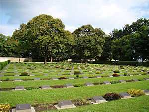
This cemetery remembers British and Indian soldiers who fought and died in the Second World War (1944).
Women's Market (Ima Keithel)
The market stalls are all run by women, and it is reportedly the only such market in the world.[6]
.jpeg)
ISKCON Temple
The ISKCON Temple is near the road from Imphal Airport to the city.
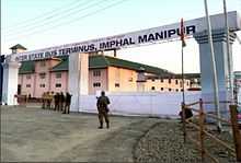
Transport
Road
Imphal is connected by road to Silchar via National Highway 37, to Aizwal via National Highway 150 and to Dimapur and Tumu in Myanmar via National Highway AH-1. Other main roads in Imphal are the Uripok-Kangchup road, the RIMS road, the Nagamapal-Thangmeiband road, the Mayai-lambi road, Palace Compound road, Dingku Road and the JNIMS Hospital road. Private taxis and city buses are in regular service as urban transport.
Air
.jpeg)

.jpeg)
Imphal International Airport is 8 kilometres (5.0 mi) south of the city.[7] It is the third-largest airport in northeast India, with postal air-cargo service six days a week. A new terminal building with cold-storage facilities is planned.[8] Air India, IndiGo, Jet Airways, Air India Regional, JetKonnect and North East Shuttle offer service to major cities such as Delhi, Kolkata and Guwahati and regional airports such as Agartala, Silcher, Aizawl and Jorhat. Connections with Rangoon and Mandalay, Myanmar and Bangkok, Thailand are planned.
Rail
In October 2012, India's Cabinet Committee on Infrastructure approved an extension of the Jiribam-Silchar railway to Imphal. The extension is expected to reach the city by March 2016.[9]
Demographics
According to the 2011 Indian census, Imphal's population was 264,986 (128,931 men and 136,055 women). The population of the metropolitan area was 414,288 (201,635 men and 212,653 women). The number of literate people in the city was 219,261 (110,809 men and 108,452 women). Imphal's literacy rate averaged 91.70 percent (95.87 for men and 87.80 for women). The city's sex ratio was 1,055 women for every 1,000 men. The sex ratio for children was 939 girls to 1,000 boys. There was a total of 25,877 children from birth to age six in Imphal (13,347 boys and 12,530 girls), 9.77 percent of the city's total population.
The Imphal metropolitan area is made up of Bijoy Govinda, Chingangbam Leikai, Imphal, Khongman, Khurai Sajor Leikai, Kiyamgei, Kongkham Leikai (portion), Laipham Siphai, Lairikyengbam Leikai, Lamjaotongba, Lamshang (core town), Langjing, Langthabal Kunja, Langthabal Mantrikhong (portion), Lilong (Imphal West) (core town), Lilong (Thoubal), Naorem Leikai, Naoria Pakhanglakpa, Oinam Thingel, Porompat, Porompat Plan Area, Sagolband (portion), Takyel Mapal, Thongju and Torban (Kshetri Leikai).[1]
Education
Universities
Technical colleges
Medical colleges
- Regional Institute of Medical Sciences[12]
- Jawaharlal Nehru Institute of Medical Science[13]
See also
References
- ↑ 1.0 1.1 Census2011.co.in. 2011. Retrieved 2011-09-30.
- ↑ 2.0 2.1 2.2 "Imphal, India". India Meteorological Department. Retrieved 16 May 2014.
- ↑ Falling Rain Genomics, Inc – Imphal
- ↑ 4.0 4.1 "Climate: Imphal - Climate graph, Temperature graph, Climate table". Climate-Data.org. Retrieved 31 October 2013.
- ↑ 5.0 5.1 "Ever recorded Maximum and minimum temperatures upto 2010" (PDF). India Meteorological Department. Retrieved 16 May 2014.
- ↑ "Ima Keithel – A market by women". She. msn. Retrieved 25 November 2012.
- ↑ "Imphal". Airports Authority of India. Retrieved 25 November 2012.
- ↑ http://www.ibef.org/download/Manipur_271211.pdf
- ↑ "Govt approves rail link to Imphal". The Indian Express. 26 October 2012. Retrieved 25 November 2012.
- ↑ http://en.manipuruniv.ac.in/
- ↑ http://www.nitmanipur.ac.in/
- ↑ "Regional Institute of Medical Sciences". Retrieved 28 January 2014.
- ↑ "JNIMS". Retrieved 28 January 2014.
External links
| Wikimedia Commons has media related to Imphal. |
| ||||||||||||||||||||||||||||||||||||||
| ||||||||||||||||||||||