Imljani
| Imljani | |
|---|---|
 | |
 Location of Imljani in Bosnia and Herzegovina | |
| Coordinates: 44°24′N 17°28′E / 44.400°N 17.467°ECoordinates: 44°24′N 17°28′E / 44.400°N 17.467°E | |
| Country | Bosnia and Herzegovina |
| Entity | Republika Srpska |
| Municipality | Skender Vakuf/Kneževo |
| Population (1991) | |
| • Total | 1,565 |
| Time zone | EET (UTC+2) |
| • Summer (DST) | EEST (UTC+3) |
| Postal code | 78234 |
| Area code(s) | (+387) 51 |
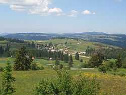
Imljani (Cyrillic: Имљани), is a village in Bosnia and Herzegovina, Entity of Republika Srpska, Skender Vakuf Municipality. It consists of a few hamlets spreading on the Undervlašić's plateau, above the canyons of Ilomska and Ugar rivers. Actually, it covers the sub-plateau in the area of the angle between Korićanske stijene and Ugarske stijene (Ugar'sRocks).[1][2][3][4]
Central hamlet Vidovište is on (around) 1200 meters above see level. Around Vidovište, from Kobilja river (south-west) to Ilomska's canyon (north-east) there are the hamlets, as follows - North-eastern: Rijeka, Potok, Ponorci, Osredok, Benići, Škeljići, Pušići, Marići, Đenići and Đekin Do; South-western: Vujinovići, Makarići, Kelemeni, Novakovići, Šodolovići and Borje.
Abow Ilomska River there is Korićani Willage and a canyon below it (Korićanske stijene), the scaffold of more than 200 Bosniaks and Croats – the victims of the Serbs Police and Army forces (at August 21, 1992), which was improved by The ICTY Tribunal in The Hague.[5][6][7][8][9][10][11][12][13][14][15][16][17][18][19]
Population
Ethnic composition, 1991 census
| colspan ="7" style="background: bgcolor="#F28500" | Ethnic composition of Skender Vakuf municipality, by settlements, 1991. census | ||||||
| style="background: bgcolor="#F5DEB3" | settlement | style="background: bgcolor="yellow" | total | style="background: bgcolor="red" | Serbs | style="background: bgcolor="#228B22" | Muslims | style="background: bgcolor="#4169E1" | Croats | style="background: bgcolor="#C71585" | Yugoslavs | style="background: bgcolor="#CC7722" | others |
| Imljani | 1,565 | style="background: bgcolor="red" | 1,544 | 3 | 1 | 5 | 12 |
See also
- Skender Vakuf
- Ilomska
- Ugar
- Korićanske stijene
References
- ↑ Vojnogeografski institut, Izd. (1955): Travnik (List karte 1:100.000, Izohipse na 20 m). Vojnogeografski institut, Beograd.
- ↑ Spahić M. et al. (2000): Bosna i Hercegovina (1:250.000). Izdavačko preduzeće „Sejtarija“, Sarajevo.
- ↑ Mučibabić B., Ed. (1998): Geografski atlas Bosne i Hercegovine. Geodetski zavod BiH, Sarajevo.
- ↑
- ↑ http://archive.cyark.org
- ↑ Korićani Cliffs massacre
- ↑ bs:Masakr na Korićanskim stijenama.
- ↑ hr:Masakr na Korićanskim stijenama.
- ↑ http://www.bim.ba/en/181/10/21824/
- ↑ http://www.trial-ch.org/en/trial-watch/profile/db/facts/damir_ivankovic_804.html
- ↑ http://www.trial-ch.org/en/trialwatch/profile/db/facts/babic_zoran_803.html
- ↑ http://www.bim.ba/en/181/10/21824/
- ↑ http://www.trial-ch.org/en/trial-watch/profile/db/facts/gordan_djuric_798.html
- ↑ http://www.trial-ch.org/en/trialwatch/profile/db/facts/milorad_radakovic_800.html
- ↑ http://www.trial-ch.org/en/trial watch/profile/db/facts/milorad_skrbic_801.html
- ↑ http://www.trial-ch.org/en/trial-watch/profile/db/facts/ljubisa_cetic_799.html
- ↑ http://www.trial-ch.org/en/trial watch/profile/db/facts/jankovic_dusan_797.html
- ↑ http://www.trial-ch.org/en/trial-watch/profile/db/facts/zeljko_stojnic_802.html
- ↑ http://www.icty.org/x/cases/mrda/cis/en/cis_mrdja_en.pdf
| ||||||