Imeon Range
| Imeon Range | |
|---|---|
|
Southern Imeon Range from Osmar Strait, with Mount Foster on the right. | |
| Highest point | |
| Peak | Mount Foster |
| Elevation | 2,105 m (6,906 ft) |
| Dimensions | |
| Length | 30 km (19 mi) |
| Width | 6.8 km (4.2 mi) |
| Geography | |
|
<div style="padding:2px 2px 5px 2px;> 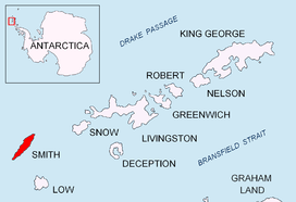 Location of Smith Island in the South Shetland Islands | |
| Country | Antarctica |
| State/Province | South Shetland Islands |
| Range coordinates | 62°58′30″S 62°30′20″W / 62.975°S 62.5056°WCoordinates: 62°58′30″S 62°30′20″W / 62.975°S 62.5056°W |
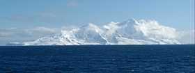

Imeon Range (Bulgarian: Хребет Имеон, ‘Hrebet Imeon’ \'hre-bet i-me-'on\) (62°58′30″S 62°30′20″W / 62.97500°S 62.50556°W) is a mountain range occupying the interior of Smith Island in the South Shetland Islands, Antarctica. Extending 30 km in southwest-northeast direction between Cape James and Cape Smith, and 6.8 km wide. Its summit Mount Foster – summit of the South Shetlands archipelago too – is a double peak, the higher south height of which (2105 m) was first climbed on January 30, 1996 by a New Zealand team led by Greg Landreth. Other prominent peaks include Evlogi Peak (2090 m), Antim Peak (2080 m), Mount Pisgah (1860 m), Slaveykov Peak (1760 m), Neofit Peak (1750 m), Drinov Peak (1630 m), Riggs Peak (1690 m) and Mount Christi (1280 m).
The range is named after Mount Imeon (present day Pamir, Hindu Kush, and Tian Shan), whose highlands and valleys around upper Oxus River (Amu Darya) were the ancient homeland of Bulgars as described in the seventh century Armenian geography index ‘Ashharatsuyts’ by Anania Shirakatsi.
See also
- Smith Island
- List of Bulgarian toponyms in Antarctica
Map
- L.L. Ivanov. Antarctica: Livingston Island and Greenwich, Robert, Snow and Smith Islands. Scale 1:120000 topographic map. Troyan: Manfred Wörner Foundation, 2010. ISBN 978-954-92032-9-5 (First edition 2009. ISBN 978-954-92032-6-4)