Ilhabela
| Ilhabela | |||
|---|---|---|---|
|
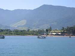
View of Pereque Beach from ferry-boat | |||
| |||
| Nickname(s): Ilhabela, Capital da Vela (Ilhabela, Capital of Sailing) | |||
| Motto: Ilhabela da Princesa | |||
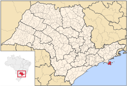
 Location in the state of São Paulo and Brazil | |||
| Coordinates: 23°48′54″S 45°22′14″W / 23.81500°S 45.37056°WCoordinates: 23°48′54″S 45°22′14″W / 23.81500°S 45.37056°W | |||
| Country | Brazil | ||
| Region | Southeast | ||
| State | São Paulo | ||
| Settled | September 3, 1805 | ||
| Government | |||
| • Mayor | Toninho Colucci (PPS) | ||
| Area | |||
| • Total | 348.3 km2 (130 sq mi) | ||
| Elevation | 0-1,378 m (0-4,521 ft) | ||
| Population (2012)[1] | |||
| • Total | 29,308 | ||
| • Density | 765/km2 (1,980/sq mi) | ||
| Time zone | UTC-3 (UTC-3) | ||
| • Summer (DST) | UTC-2 (UTC-2) | ||
| Postal Code | 11630-000 | ||
| Area code(s) | +55 12 | ||
| HDI (2000) | 0.781 – medium[2] | ||
| Website | Prefeitura Municipal de Ilhabela | ||
Ilhabela (Portuguese for Beautiful Island) is an archipelago and city situated 4 miles off the coast of São Paulo state in Brazil. The island is 205 km (127 mi) from the city of São Paulo and 340 km (210 mi) from the city of Rio de Janeiro. The largest island, although commonly called Ilhabela, is officially named Ilha de São Sebastião (St. Sebastian Island). It, the other islands (Búzios, Pescadores and Vitória) and the islets (Cabras, Castelhanos, Enchovas, Figueira, Lagoa and Serraria) make up the municipality of Ilhabela.
The islands in total cover 348 km2 (134 sq mi). The population of Ilhabela in 2006 was 26,230,[3] and in 2012 it was around 29,308, but during the holiday months, up to one hundred thousand people may be on the island,[4] since it is a popular destination for tourists. To access the city, one must take a boat or ferry in São Sebastião, as there are no roads which reach it. During the summer, one may wait more than an hour to take the ferry boat. The ferry takes 15 minutes to cross the channel between the two cities.
History
Before Portugal colonized Brazil in 1500, an indigenous tribe called the Tupinambas, inhabited the island. They called the island 'Ciribai', which means tranquil place.
The island was named São Sebastião Island by Americo Vespuccio, on January 20, 1502. During the 16th century, the Portuguese set up military points on the shore of São Sebastião Island.
On September 3, 1805, the Governor of the Province of São Paulo, Antônio José da França e Horta, decreted the political-administrative independence of the county. The Island had already 3.000 inhabitants at that time. The new county was named Villa Bella da Princeza, paying homage to the princess of Beira.
On November 30, 1938, during the Getúlio Vargas' Estado Novo, an act altered the name of the county to Formosa. Six years later, on November 30, 1944, another act ultimately changed the name to Ilhabela.
Nowadays, the city is a popular touristic destination. Among the current critical issues of the island, is the lack of proper sewage pipes to collect all houses' wastewater. As of January 2012, 46,6% of the buildings in the island lacked such infrastructure.[5]
Geography


The municipality comprises the main island, Ilha de São Sebastião, and three smaller inhabited islands: Buzios and Vitória islands, 7½ and 2½ km away from the northeastern tip of the main island, respectively, and Pescadores Island, near Vitória Island. Buzios and Vitória are home to 142 and 50 caiçaras, respectively.[6] There are also the very small islets (das Cabras, da Sumítica, da Serraria, dos Castelhanos, da Lagoa, da Figueira e das Enchovas islands). Almost all the urbanized areas are in the very narrow plains between the sea and the mountains of the main island, preferably at the west part of the island, facing the continent.
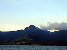
A short (30 km) but high mountain range forms this main island, reaching above 1,000 meters in seven different points - Pico de São Sebastião (1,378 m), Morro do Papagaio (1,307 m), Pico da Serraria (1,285 m), Morro do Ramalho (1,205 m), Morro do Simão (1,102 m), Morro das Tocas 1,079 m) and Pico do Baepi (1,048 m). Running approximately 8 km into the Atlantic Ocean off the southeast corner of the island, there is the Península do Boi (Ox Peninsula). The east side of the island is inhabited by very few people, who concentrates mainly on the Castelhanos beach, the only on this side accessible by road. Only 4x4 jeeps are able to cross this particular road, though.[7])
Most of the city has an Humid subtropical climate, but the mountains have an Oceanic climate, because of the high altitude. The Atlantic Forest covers the entire city.
Tourism
Ilhabela is a popular sailing point.[4][8] Several regattas take place at the city's coast.[8] Also, it is popular for many other watersports, including scuba and free diving.[8] The waters around the archipelago are filled with more than 50 shipwrecks, six of them being opened for visiting via diving.[9]
There are many hiking trails with varying degrees of difficulty and 360 waterfalls[9] in the Atlantic jungle.
Beaches
There are 41 beaches on the main island.[7] The ones located along the channel are in general urbanized and feature calm to moderate waves. The ones facing the ocean are clean and less affected by humans, besides featuring stronger waves, which attracts surfers.[7] These can only be reached by foot and/or by boat, the exception being Castelhanos, as explained above. Bonete was considered the ninth best beach of Brazil by The Guardian.[10] Starting from Castelhanos and going counterclockwise, the beaches are:
|
|
Transportation

The only way to access the island by car is via the ferry boats that cross the channel. The boats can carry up to 70 vehicles and take 15 minutes to sail through the 2.4 kilometers that separate the two stations. The SP-131 is the main road on the main island, running along the west face of the island and half the way of the southern and northern faces (both these edges are not paved). It has different names throughout its path.
References
- ↑ "2012 Populational Estimate" (PDF). Censo Populacional 2012. Instituto Brasileiro de Geografia e Estatística (IBGE). July 2012. Retrieved August 31, 2012.
- ↑ Índice de Desenvolvimento Humano - Municipal, 1991 e 2000 - Todos os municípios do Brasil - UNDP
- ↑ 2006 population statistics of IBGE
- ↑ 4.0 4.1 Bueno, Chris (1 June 2010). "Ilhabela: Conheça as belezas da maior ilha marítima brasileira!" (in Portuguese). 360 Graus. Retrieved 8 January 2012.
- ↑ Geraque, Eduardo; Talita Bedinelli; Daniel Marenco (29 January 2012). "Esgoto de 31 mil casas do litoral vão parar no mar". Folha de S.Paulo (in Portuguese) (São Paulo, Ilhabela). p. C5.
- ↑ da Silva, José Benedito (8 January 2012). "Falta de tudo, menos quem tenha Oliveira no sobrenome" (in Portuguese). Folha de S.Paulo.
- ↑ 7.0 7.1 7.2 Nogueira, Kiko (2007). Guia Quatro Rodas Praias 2007 (in Portuguese). São Paulo: Editora Abril. p. 92.
- ↑ 8.0 8.1 8.2 Santos, Raquel. "Capital da vela é destino certo para todos os gostos e idades" (in Portuguese). Guia do Litoral. Retrieved 8 January 2012.
- ↑ 9.0 9.1 "Ilhabela at Brasil Turismo". Retrieved 8 January 2012.
- ↑ McOwan, Gavin (15 April 2009). "Top 10 beaches in Brazil". The Guardian. Retrieved 3 August 2012.
External links
| Wikimedia Commons has media related to Ilhabela. |
- (Portuguese) Ilhabela Town Hall
- (Portuguese) Ilhabela on Explorevale
- (Portuguese) NGO dedicated to Ilhabela's preservation
 |
Caraguatatuba |  | ||
| São Sebastião | |
Atlantic Ocean | ||
| ||||
| | ||||
| Atlantic Ocean |


