Ilfis (river)
| Ilfis | |
|---|---|
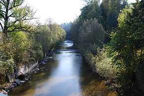 Ilfis in Langnau im Emmental, Canton of Bern, Switzerland | |
| Origin |
Schrattenfluh 46°50′20″N 7°57′22″E / 46.839°N 7.956°E |
| Mouth |
Emme (Langnau im Emmental/Lauperswil) 46°57′02″N 7°45′01″E / 46.9506°N 7.7504°ECoordinates: 46°57′02″N 7°45′01″E / 46.9506°N 7.7504°E |
| Progression | Emme-Aare-Rhine-North Sea |
| Basin countries | Switzerland |
| Length | 21.5 km (13.4 mi) |
| Mouth elevation | 645 m (2,116 ft) |
| Basin area | 188 km2 (73 sq mi) |
| Left tributaries | Schonbach, Wittenmossgraben, Schärligbach, Steinbach, Chrümpelgraben, Ortbach, Teufenbachgraben, Ramserengraben, Mülebach |
| Right tributaries | Hilfernbach, Staldegrabe, Rämisbach, Eschlissbach, Türrenbachgrabe, Hämelbach, Trubbach, Gohl, Frittenbach |
The Ilfis (in the local dialect: [(d̥) ˈʏu̯fiz̥/ˈɪu̯fiz̥]) is a Swiss river in the Cantons of Bern and Lucerne. It runs through the Entlebuch and upper Emmental regions before joining the Emme river.
Name
The earliest evidence of the name Ilfis comes from the year 1337 where it might refer to either the village of Ilfis, now part of Langnau im Emmental, or the farms at Enedilfis, in the municipality of Escholzmatt. It first appears as a river in a document from 1371, though only a copy from 1531 still exists.[1]
The origin of the name is not fully clear. It could be a derivation of *Elvis(i)ā which comes from the Gallic color root word * elvo-, meaning brown or yellow and refer to the yellowish tint of the water.[1] It may also come from or be the origin of the name Hilfern which is often associated with the river.[2]
References
- ↑ 1.0 1.1 Erika Waser, Luzerner Namenbuch 1,1: Entlebuch. Die Orts- und Flurnamen des Amtes Entlebuch (A–L), Comenius, Hitzkirch 1996, ISBN 3-905286-56-4, p. 484f.
- ↑ Erika Waser, Luzerner Namenbuch 1,1: Entlebuch. Die Orts- und Flurnamen des Amtes Entlebuch (A–L), Comenius, Hitzkirch 1996, ISBN 3-905286-56-4, p. 430f.
External links
| Wikimedia Commons has media related to Ilfis. |