Ile Aux Galets Light
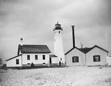 Skillagalee Island Light Station circa 1920. | |
 | |
| Location | SW OF WAUGOSHANCE ISLAND/LAKE MICHIGAN |
|---|---|
| Coordinates | 45°40′35″N 85°10′23″W / 45.67639°N 85.17306°WCoordinates: 45°40′35″N 85°10′23″W / 45.67639°N 85.17306°W |
| Year first constructed | 1888 |
| Year first lit | 1888 |
| Automated | 1969 |
| Foundation | Stone |
| Construction | Brick |
| Tower shape | Octagonal hourglass |
| Markings / pattern | white w/black lantern |
| Height | 58 feet (18 m)[1][2] |
| Focal height | 58 feet (18 m)[3] |
| Original lens | Fourth order Fresnel lens |
| Current lens | 12-inch (300 mm) Tideland Signal ML-300 acrylic plastic lens |
| Range | 11 nautical miles (20 km; 13 mi) |
| Characteristic | Fl W 6 s[4] |
| ARLHS number | USA-399[5][6] |
| USCG number |
7-17795 |
|
Skillagalee Light Station | |
| Nearest city | Cross Village, Michigan |
| Area | 2 acres (0.81 ha) |
| Governing body | United States Coast Guard |
| MPS | U.S. Coast Guard Lighthouses and Light Stations on the Great Lakes TR |
| NRHP Reference # | 84001389[7] |
| Added to NRHP | July 19, 1984 |
Ile aux Galets or Gallets, and also known as Skillagallee or Skillagalee Island, is located in northeast Lake Michigan approximately 7 miles (11 km) northwest of Cross Village, Michigan. The Emmet County, Michigan lighthouse sits atop and warns of a dangerous gravel shoal—it extends almost 2 miles (3.2 km) to the east and half a mile to the northwest[8]—that is an imminent hazard to navigation, ships and sailors.[9] This site has been the continuous operating home of a U.S. government lighthouse since 1850.
History
The islet is home to a significant colony of ring-billed gulls. Its name, given by early French explorers, means "Isle of Pebbles."[10] It is said that the English speakers found the French name unpronounceable, and "Ile aux Galets"—soon misheard, misunderstood and mispronounced—transmuted into "Skillagalee" (or some variant) which took hold. By the "mid 1800's references to the original French name all but disappeared."[11]
There are many wrecks near Skillagalee island. However, on September 27, 1850, the loss of the A.D. Patchin—a wood sidewheeler, 226 feet (69 m) long and built in Trenton, Michigan in 1846—led to the construction of the first light on the island. Loaded with general goods, the Patchin's course into Grays Reef Passage was disrupted by currents that pulled her onto Skillagalee's shore. Her crew escaped and was rescued, but foul winds and weather thwarted many attempts to set her free. She was "pounded to pieces, becoming yet another of Lake Michigan's many victims."[9]
Congress appropriated sums to construct a light on Skillagalee Island in 1851, and the task was undertaken by the Department of the Treasury, the administrative predecessor to the Lighthouse Board. Due in part to the extreme exposure of the location, that lighthouse badly and quickly deteriorated and was replaced in 1868.[9]
In 1888, the United States Lighthouse Board built the current 48-foot (15 m) tower[12] and equipped it with a 'state of the art' fourth order Fresnel lens.[13] This is the third lighthouse on the island.[10] This "handsome" lighthouse shares its design and shape with only one other, Port Sanilac Light, on Lake Huron.[14]
In 1890, the station's fog signals were upgraded from the existing steam siren to 10-inch (250 mm) steam whistles. On October 4, the Lighthouse steam barge RUBY delivered a work party and the necessary equipment for the upgrade. Within the month the task was completed, and the old sirens were thereupon transferred to Beaver Island Head Light. "Life was busy for the keepers . . . that following year, since in addition to tending the light and maintaining the equipment, they operated the station's new steam whistles . . . 268 hours, [stoking] 26 tons of coal into their boilers." In 1894 the boathouse, boatways and landing crib were moved fifteen feet toward the lake, due to the ever fluctuating water levels.[9]
The islet and lighthouse were occupied by lighthouse keepers from 1850 until 1969, when the Fresnel lens was retired. At the time, a Coast Guard crew razed all the structures (fog signal building, keeper's house, oil storage shed and boathouse), leaving only the tower in the middle of the island.[15] An automated 12-inch (300 mm) ML-300 Tideland Signal acrylic plastic lens was placed in the lantern,[16] powered by 12-volt batteries attached to a photovoltaic array mounted on the parapet's railing.[9]
Except for the light itself, the fog horn sound building, keeper's dwelling and all other structures were razed.[17]
In June 2011, the General Services Administration made the Ile Aux Galets Light (along with 11 others) available at no cost to public organizations willing to preserve them.[18][19]
Current status
The light is listed on the National Register of Historic Places Reference #84001389; Name of Listing: SKILLAGALEE LIGHT STATION.[20]
Getting there
It is accessible only by small boat.[10] Due to shallow water and dangerous reefs and shoals, any close approach to the island by boat is almost impossible (one source notes: "dangerous waters, and there are no facilities for landing on the island");[14] and the light is closed in any event.[21]
Another alternative is to charter a seaplane to make a tour of the Mackinac Straits and environs.[22]
The island can be accessed by sea kayak. Good weather and sea kayaking experience are imperative in such a venture.[23]
References
- ↑ Pepper, Terry. "Database of Tower Heights". Seeing the Light. terrypepper.com.
- ↑ Michigan Lighthouse Conservancy, Waugoshance Light.
- ↑ Pepper, Terry. "Database of Focal Heights". Seeing the Light. terrypepper.com.
- ↑ Light List, Volume VII, Great Lakes (PDF). Light List. United States Coast Guard.
- ↑ Amateur Radio Lighthouse Society, Ile aux Galets/Skillagalee Light, ARLHS USA-399.
- ↑ Amateur Radio Lighthouse Society, World List of Lights (WLOL).
- ↑ "National Register Information System". National Register of Historic Places. National Park Service. 2009-03-13.
- ↑ Detroit News, Interactive map on Michigan lighthouses.
- ↑ 9.0 9.1 9.2 9.3 9.4 Terry Pepper, Seeing the Light, Skillagallee Island Light Station.
- ↑ 10.0 10.1 10.2 Wobser, David, boatnerd.com, Ile Au Galets, Skillagalee Island Lighthouse.
- ↑ Terry Pepper, Seeing the Light, Skillagallee Island Light Station. This is similar to the mutation of "Seul Choix Harbor" into 'sishwa' or the development of the peculiarly named Waugoshance Light.
- ↑ Lighthouse Central, Photographs, History, Directions and Way points for Skillagalee Island Light, The Ultimate Guide to West Michigan Lighthouses by Jerry Roach (Publisher: Bugs Publishing LLC - 2005). ISBN 0-9747977-0-7.
- ↑ "Historic Light Station Information and Photography: Michigan". United States Coast Guard Historian's Office. Ile Aux Galets/Skillagalee Island Light.
- ↑ 14.0 14.1 Rowlett, Russ. "Lighthouses of the United States: Michigan's Eastern Lower Peninsula". The Lighthouse Directory. University of North Carolina at Chapel Hill.
- ↑ National Park Service, Inventory of Historic Lighthouses, Maritime Heritage, Ile Aux Galets (Skillagalee Island) light.
- ↑ 300 m.m. acrylic optic lens, Terry Pepper, Seeing the Light
- ↑ National Park Service Inventory of Historic Lighthouses, Maritime Heritage Program, Skilagalee (Ile Aux Galets) Light.
- ↑ "For sale: Waterfront property; cozy, great views, plenty of light, needs TLC". CNN. Retrieved 12 July 2011.
- ↑ Beatty, MaryAnne. "GSA Making 12 Historic Lighthouses Available at No Cost to Public Organizations Willing to Preserve Them". GSA Website. US General Services Administration. Retrieved 12 July 2011.
- ↑ Michigan Lighthouse Conservancy, Skillagalee Island Light.
- ↑ Lighthouse friends, Skillagalee Island (Ile Aux Galets) Light.
- ↑ A seaplane tour of the Straits
- ↑ http://gokayaknow.com/index.php/sea-kayaking/sea-kayak-trip-report-from-ile-aux-galet/ An account of a trip to Ile aux Galets by sea kayak.
Further reading
- "A Tour of the Lights of the Straits." Michigan History 70 (Sep/Oct 1986), pp. 17–29.
External links
- Lighthouses in the Mackinac Straits.
- Interactive map of Lights in Northern Lake Michigan, mapped by Google.
- Lighthouse Friends, Lighthouses in the Mackinac Straits, (Skillagalee Island Light).
- Map of Michigan Lighthouse in PDF Format.
| ||||||||||||||||||||||||||||||||||||||||

| ||||||||||||||||||||||||||