Ikwuano
| Ikwuano | |
|---|---|
| LGA and town | |
 Ikwuano | |
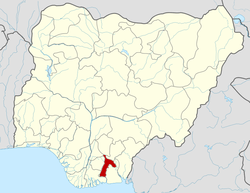
| Coordinates: 5°26′N 7°34′E / 5.433°N 7.567°ECoordinates: 5°26′N 7°34′E / 5.433°N 7.567°E | |
| Country |
|
| State | Abia State |
| Area | |
| • Total | 108 sq mi (281 km2) |
| Population (2006) | |
| • Total | 137,993 |
| Time zone | WAT (UTC+1) |
Ikwuano is a Local Government Area of Abia State, Nigeria. Its headquarters is in Isiala Oboro.
It has an area of 281 km² and a population of 137,993 at the 2006 census.
The postal code of the area is 440.[1]
References
- ↑ "Post Offices- with map of LGA". NIPOST. Retrieved 2009-10-20.
| |||||||||||||