Ikawa, Akita
| Ikawa 井川町 | |||
|---|---|---|---|
| Town | |||
|
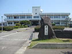
Ikawa Town Hall | |||
| |||
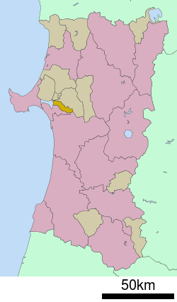 Location of Ikawa in Akita Prefecture | |||
 Ikawa
| |||
| Coordinates: 39°54′51″N 140°4′54″E / 39.91417°N 140.08167°ECoordinates: 39°54′51″N 140°4′54″E / 39.91417°N 140.08167°E | |||
| Country | Japan | ||
| Region | Tōhoku | ||
| Prefecture | Akita | ||
| District | Minamiakita | ||
| Area | |||
| • Total | 47.95 km2 (18.51 sq mi) | ||
| Population (August 2013) | |||
| • Total | 5,198 | ||
| • Density | 108/km2 (280/sq mi) | ||
| Time zone | Japan Standard Time (UTC+9) | ||
| - Tree | Pine | ||
| - Flower | Sakura | ||
| - Bird | Copper Pheasant | ||
| Phone number | 018-875-5800 | ||
| Address | Kita-Kawajiri-aze, Ikawa-machi, Minamiakita-gun, Akita-ken 018-1596 | ||
| Website | Official website | ||

Ikawa (井川町 Ikawa-machi) is a town located in Minamiakita District, Akita, Japan. As of August 2013, the town had an estimated population of 5,198 and a population density of 108 persons per km². The total area was 47.95 km².
Geography
Iikawa is located in the coastal flatlands northeastern Akita Prefecture, bordered by the remnant of Lake Hachirōgata which lies in the west of the town. Lake Hachirōgata was the second largest lake in Japan until it was drained in a land reclamation project from 1957 to 1977.
Neighboring municipalities
- Akita Prefecture
History
The area of present-day Ikawa was part of ancient Dewa Province, dominated by the Satake clan during the Edo period, who ruled Kubota Domain under the Tokugawa shogunate. The villages of Kami-Ikawa and Shimo-Ikawa were established in 1889, and were merged to form Ikawa Village on February 1, 1955. The village was raised to town status on June 1, 1974. Efforts to merge the town with neighboring Hachirōgata and Gojōme in 2005 were not successful.
Economy
The economy of Ikawa is based on agriculture.
Transportation
Railway
- JR East - Ōu Main Line
Highway
Noted people from Ikawa
- Hananoumi Ken – sumo wrestler
External links
![]() Media related to Ikawa, Akita at Wikimedia Commons
Media related to Ikawa, Akita at Wikimedia Commons
- Official website (Japanese)
| ||||||||||||||||||||||||||||||||