Ikaruga, Nara
| Ikaruga 斑鳩町 | ||
|---|---|---|
| Town | ||
| ||
 Location of Ikaruga in Nara Prefecture | ||
 Ikaruga Location in Japan | ||
| Coordinates: 34°37′N 135°44′E / 34.617°N 135.733°ECoordinates: 34°37′N 135°44′E / 34.617°N 135.733°E | ||
| Country | Japan | |
| Region | Kansai | |
| Prefecture | Nara Prefecture | |
| District | Ikoma | |
| Area | ||
| • Total | 14.27 km2 (5.51 sq mi) | |
| Population (November 30, 2006) | ||
| • Total | 28,685 | |
| • Density | 2,000/km2 (5,200/sq mi) | |
| Time zone | Japan Standard Time (UTC+9) | |
| Symbols | ||
| - Tree | Japanese Black Pine | |
| - Flower | Camellia sasanqua | |
| Address |
3-7-12 Hōryūjinishi, Ikaruga-cho, 630-8580 | |
| Phone number | 0745-74-1001 | |
| Website |
www | |


Tatsuta River

Gate to Horyū-ji in Ikaruga
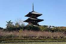
Hokki-ji
Ikaruga (斑鳩町 Ikaruga-chō) is a town in Ikoma District, Nara, Japan.
Ikaruga is home to Hōryū-ji and Hokki-ji, ancient Buddhist temples collectively inscribed as UNESCO World Heritage. Other ancient temples include Hōrin-ji, also in the vicinity of Hōryū-ji. The town was named after the Palace of Prince Shōtoku-Taishi, Ikaruga-no-Miya (Imperial Palace of Ikaruga, or Imperial House of Ikaruga), whose grounds were at Hōryū-ji, thus it is also called Ikaruga-dera (temple of Ikaruga).
As of November 30, 2006, the town has an estimated population of 28,685. The total area is 14.27 km2 (6 sq mi).
Neighboring municipalities
Geography
- Tatsuta River (Nara Prefectural Tatsuta Park)
- Yamato River
- Mount Matsuo
Education
Elementary schools
- Ikaruga Elementary School
- Ikarugahigashi Elementary School
- Ikaruganishi Elementary School
Junior high schools
- Ikaruga Junior High School
- Ikarugaminami Junior High School
High schools
- Hōryū-ji International High School
Notable places
Temples and shrines
Kofun
- Fujinoki Kofun
- Kasuga Kofun
- Okanohara Kofun
- Terayama Kofun
External links
| Wikimedia Commons has media related to Ikaruga, Nara. |
- Official website (Japanese)
| ||||||||||||||||||||||||||||||||||||
| Wikimedia Commons has media related to Ikaruga, Nara. |