Ijevan
| Ijevan Իջևան | |
|---|---|
|
Ijevan | |
 Ijevan Իջևան | |
| Coordinates: 40°52′32″N 45°08′57″E / 40.87556°N 45.14917°E | |
| Country |
|
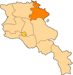
| Marz | Tavush |
| Founded | 1780s |
| City status | 1961 |
| Area | |
| • Total | 4.6 km2 (1.8 sq mi) |
| Elevation | 755 m (2,477 ft) |
| Population (2009) | |
| • Total | 20,500 |
| • Density | 4,500/km2 (12,000/sq mi) |
| Time zone | GMT +4 (UTC+4) |
| Postal code | 4001, 4002 |
| Area code(s) | (+375) 263 |
| Vehicle registration | 57 |
| Sources: Population [1] | |

Coordinates: 40°52′32″N 45°08′57″E / 40.87556°N 45.14917°E Ijevan (Armenian: Իջևան; formerly Karavansara) is a city in Armenia and the administrative centre of Tavush Province. It is located in the northern part of the region, on the foot of Ijevan ridge and Nal'teket ridge on both banks of Aghstev River. The city's current name, Ijevan, and its former name Karavansara (until 1919) both mean "inn" (caravanserai), in Armenian and Persian, respectively.[2] The city's population as of 2009 is 20,500 making it the most populated city in the province. It is 137 km to the north-east of Yerevan. Currently, the mayor of the city is Vardan Ghalumyan who runs Ijevan alongside a fifteen-member council.[3] The Yerevan-Tbilisi highway passes through the city. Ijevan has a railway station since 1870.
History

It is said by tradition that about 2000 years ago, King Artavasdes I built a city on the place of modern-day Ijevan. He gathered only the beautiful girls and the handsome boys from all over Armenia, so that latter they would get married and settle in the newly established town. Thus, the successors of that handsome generation live today in Ijevan.
Being located on a very important trade route between the Levant and Northern Caucasus, the region was home to many rest-houses and caravanserais for the merchants and their caravans. In the 1780s, during the Persian rule, the village of Karavansara was founded.[4] In 1801, the area of Ijevan along with Lori Province and the Georgian territories became part of the Russian Empire. During the rule of Paul I, approximately 6000 Armenian families from Karabakh were allowed to move to the valley of Aghstev river and occupy the region around Karavansara village.
In 1919, after the independence of Armenia, the name of the settlement of Karavansara was changed into Ijevan.
On 29 November 1920, Ijevan was the venue of the first Soviet rule in Armenia after being invaded by the Red Army from the north.
Chamber tombs near the city hospital and a late Bronze Age cemetery on the left bank of Aghstev attest to the early occupation of the site.[5] The remains of a medieval caravanserai could be found on the banks of Aghstev river on a site called Hamam-Jala.
Ijevan was granted the status of urban community in 1970.
Geography

Occupying the valley of Aghstev river at a height of 755 meters above sea level,[6] the city is surrounded with high mountains covered with thick forests, turning into alpine meadows in certain areas. The average temperature of the year is 10.6 C, in January 0 C, while in July 21.3 C. The maximum temperature registered ever in Ijevan is +37 C and the minimum is -23. The annual precipitation is 562 mm. At the entrance of the town there is a small lake called "Spitak". It is near the town of Kayan.
Economy
During the Soviet rule, the town had witnessed a remarkable industrial progress especially in the spheres of carpet manufacturing and wood processing. The carpet-weaving factory of Ijevan was the largest in the Caucasus and the 3rd largest in the whole Soviet Union. Unfortunately, after the collapse of the Soviet rule and the resulting economic crisis in Armenia, most of those enterprises were destined to shut their doors.
Nowadays, there are small food processing manufactories and machinery plants in the town. But the most important firm is the "Ijevan Wine Factory" which is located at the entrance of the town with its massive tower marked with the word "IJEVAN" on top.[7] The wine factory is processing since 1976, and is famous for its pomegranate wine.[8] The city has a local television station and its own newspapers.[9]
However, unemployment rates are still in high levels in Ijevan.
Education and culture

Since 1994, a branch of Yerevan State University is located in the city with approximately 700 students studying in applied mathematics, physics, Armenian language and literature, history, pedagogy and psychology.[10] There are 6 schools for public education and 3 kindergartens in the town.
Ijevan used to host an annual symposium of sculpture between 1985 and 1990 with the presence of many experts from all over the world. Therefore, the residents of Ijevan started to call their town "The city of 100 sculptures". In fact, there are 116 sculptures enhancing the centre of Ijevan nowadays.
The small ethnographic museum of Ijevan was reopened in 1999 while the art gallery was renovated in 2003.[11] The church of Surp Hovhannes is located in the southern part of the town. Another church in Ijevan has been built and financed by an Armenian benefactor from Boston.
Tourism and attractions

Tavush is one of the most picturesque regions in Armenia. Nestled in the valley of Aghstev surrounded with forests and high mountains, Ijevan is more likely a forest-resort. The town has a 200-bed high-rise hotel built in 1969 on the northern side of the main road. The area is home to several historic monuments of Armenian Architecture:
- Makaravank Monastery of the 10th century in Achajur village 16 km north of Ijevan. This purple and green stone complex in the forest above the village is a very popular destination.
- Arakelots Monastery of the 13th century few kilometers north of Ijevan near Kirants village.
- Kirants Monastery of the 8th century 10 km north of Ijevan.
- Gandzakar village monastery few kilometers south of Ijevan.
- Yenokavan Canyon, near Yenokavan village north of Ijevan. Characterized with beautiful cliffs, caves, forests, rivers and cascades. "Anapat cave" has a style of pre-Christian unique carvings which resemble Mayan and Aztec works. There are small rest houses and a modern resort in Yenokavan canyon.
Sports
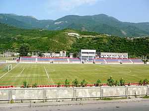
Ijevan has the all-seater Arnar Stadium, built in 2007 and hosted the Armenian Independence Cup final match in 2008 for the first and the only time being played outside the capital Yerevan. FC Bentonit Ijevan was the only professional football club in the town, dissolved in 2007 due to financial difficulties.
Sister cities
-
 Valence, Drôme (France) since 1996
References
- ↑ Armstats:Population
- ↑ Kiesling, Rediscoving Armenia, p. 111, available online at the US embassy to Armenia's website
- ↑ "Malcolm Simpson, Community-Based Economic Development Strategy, City of Ijevan, Armenia, 2003-2006" (PDF). 2002. Retrieved 2008-06-06.
- ↑ Lusamut
- ↑ "ArmeniaPedia.org, Ijevan Town". Retrieved 2009-01-04.
- ↑ Weather forecast for Ijevan in Tavush (Armenia), 755 m.
- ↑ Ijevan Winery (Russian)
- ↑ Ijevan Wine Factory
- ↑ "Albert Ghaltakchyan, 4th activity of the Technical Task (Agreement N C-3-020-3-F) of the “Rendering Service of Information Dissemination on Biodiversity Conservation and Protected Areas in the Gegharkunik and Tavush marzes of the Republic of Armenia”" (PDF). 16 April 2006. Retrieved 2008-06-06.
- ↑ "Yerevan State University : Structure". Retrieved 2008-06-06.
- ↑ "Radio Liberty Armenia : Archives".
- Ijevan at GEOnet Names Server
- Report of the results of the 2001 Armenian Census, National Statistical Service of the Republic of Armenia