Igoumenitsa
| Igoumenitsa Ηγουμενίτσα | |
|---|---|
|
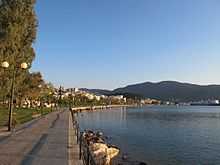
View of the old port | |
 Igoumenitsa | |
|
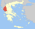
Location within the region  | |
| Coordinates: 39°29′N 20°16′E / 39.483°N 20.267°ECoordinates: 39°29′N 20°16′E / 39.483°N 20.267°E | |
| Country | Greece |
| Administrative region | Epirus |
| Regional unit | Thesprotia |
| Government | |
| • Mayor | Giorgos Katsinos |
| Area | |
| • Municipality | 426.6 km2 (164.7 sq mi) |
| • Municipal unit | 80.8 km2 (31.2 sq mi) |
| Highest elevation | 10 m (30 ft) |
| Lowest elevation | 0 m (0 ft) |
| Population (2011)[1] | |
| • Municipality | 25,814 |
| • Municipality density | 61/km2 (160/sq mi) |
| • Municipal unit | 17,902 |
| • Municipal unit density | 220/km2 (570/sq mi) |
| Time zone | EET (UTC+2) |
| • Summer (DST) | EEST (UTC+3) |
| Postal code | 461 00 |
| Area code(s) | 26650 |
| Vehicle registration | ΗΝ |
| Website | www.igoumenitsa.gr |

Igoumenitsa (Greek: Ηγουμενίτσα, Greek pronunciation: [iɣumeˈnitsa]), is a coastal city in northwestern Greece. It is the capital of the regional unit Thesprotia. Its original ancient name used to be Titani.
The 670 km (420 mi) long Egnatia Highway, which serves northern Greece, terminates at Igoumenitsa.
Municipality

The present municipality Igoumenitsa was formed at the 2011 local government reform by the merger of the following 5 former municipalities, that became municipal units (constituent communities in brackets):[2]
- Igoumenitsa (Agia Marina, Agios Vlasios, Graikochori, Igoumenitsa, Kastri, Kryovrysi, Ladochori, Mavroudi, Nea Selefkeia)
- Margariti (Eleftheri, Karteri, Katavothra, Margariti, Mazarakia, Mesovouni, Spatharaioi)
- Parapotamos (Drimitsa, Geroplatanos, Koritiani, Parapotamos)
- Perdika
- Syvota (Argyrotopos, Faskomilia, Plataria, Syvota)
History
In ancient times Igoumenitsa was known as Titani, (Gitani, Gitana, Goumani) and was one of the most important towns of the Kingdom of Thesprotis during the 4th century BC, covering 28 hectares. The circumference of its walls was 2,400 metres. The walls had four gates. Internal walls, in the shape of a sickle, divided the city in half. Its most noteworthy tower, located at the top of the hill, was round, and is thought to have been a religious sanctuary. Excavations have revealed a theatre which seats 2,500 and ruins of two temples.
The city was a meeting place of the Epirote League (Livy 42.38.1). A spur near Philiates between the Kalamas River, the acropolis had a fine semicircular tower. A small theater, towers, and gateways which are still visible. The Kalamas may have been navigable to this point. The city was destroyed by the Romans in 167 BC and later on it was annexed into the Roman Empire. It was ruled by Ottoman Empire and was renamed as "Reşadiye" in 1909 honour of Mehmet V, Ottoman Sultan between 1909 and 1918. During Italo-Turkish War, Hamidiye torpedo boat was sunk by an Italian destroyer on December 30, 1912[3] in here.
After the liberation of the region from Ottoman rule during the Balkan wars in 1913, the city name was Grava (Greek: Γράβα) which means "cave" in ancient Greek and in 1938 became head of the prefecture of Thesprotia and renamed to Igoumenitsa.
Following World War II, the Muslim Cham Albanian residents of Igoumenitsa were expelled to neighbouring Albania after large parts of them collaborated with the invading German forces.[4]
Traffic
The Patras, Greece to Brindisi, Italy car–ferry ships of the Hellenic Mediterranean Lines (HML) stop at Igoumenitsa, before crossing the Adriatic Sea and vice versa, as well as the ships of Superfast Ferries, ANEK Lines and several other shipping companies, before going to Ancona, Bari or Venice in Italy, and vice versa. Frequent passenger and car ferries to and from Corfu.
The Egnatia Odos motorway, which was opened in 2009 and is part of the ![]() , has significantly enhanced the connection with Thessaloniki and Turkey and shortened the required travelling time from and to the Turkish border by several hours. Between Thessaloniki and the Turkish border, the road runs more or less parallel to the ancient Roman Via Egnatia.
, has significantly enhanced the connection with Thessaloniki and Turkey and shortened the required travelling time from and to the Turkish border by several hours. Between Thessaloniki and the Turkish border, the road runs more or less parallel to the ancient Roman Via Egnatia.
Historical population
| Year | Town | Municipal unit | Municipality |
|---|---|---|---|
| 1981 | 6,389 | - | - |
| 1991 | 6,807 | 11,608 | - |
| 2001 | 9,104 | 14,710 | - |
| 2011 | 9,820 | 17,902 | 25,814 |
Climate
The average rainfall in Igoumenitsa is around 1,100 mm (43.3 in). By comparison in Athens it is only 380 mm (15.0 in); in Crete it is 640 mm (25.2 in), and in Ioannina 1,300 mm (51.2 in).
The temperature table are dated as of 2005.
| Month | Inland temperature | Sea temperature |
|---|---|---|
| January | 12°C | 16°C |
| February | 9°C | 15°C |
| March | 14°C | 16°C |
| April | 16°C | 17°C |
| May | 22°C | 19°C |
| June | 25°C | 22°C |
| July | 28°C | 24°C |
| August | 27°C | 25°C |
| September | 25°C | 24°C |
| October | 20°C | 23°C |
| November | 18°C | 20°C |
| December | 13°C | 17°C |
The water is safe for swimming between the months of May to November, that's only half a year. In 2005, the town had 65 rainy days, the summer had 4 rainy days with 10 hours of mix of sun and clouds each day. The last 25 years, the lowest temperature was −9 °C (16 °F) and the highest was 43 °C (109 °F).
International relations
Twin towns – Sister cities
Igoumenitsa is twinned with:
Gallery
-

Igoumenitsa as seen from Egnatia Odos
-

View of Igoumenitsa from the sea
-

Panoramic view
See also
References
- ↑ "Detailed census results 2011" (in Greek).
- ↑ Kallikratis law Greece Ministry of Interior (Greek)
- ↑ http://www.main-board.eu/guncel-sorunlar-ve-hayat/9383-1911-12-trablusgarp-savasinda-deniz-kuvvetleri.html
- ↑ Hermann Frank Meyer. Blutiges Edelweiß: Die 1. Gebirgs-division im zweiten Weltkrieg Bloodstained Edelweiss. The 1st Mountain-Division in WWII Ch. Links Verlag, 2008. ISBN 978-3-86153-447-1, p. 702
External links
- Official website (Greek)
| ||||||||||||||||||||||||||||||
| ||||||||||||||||||||||
| ||||||||||||||||||||||||||||||