Igloolik Airport
| Igloolik Airport | |||||||||||
|---|---|---|---|---|---|---|---|---|---|---|---|
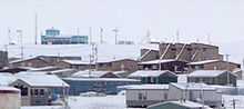 The airport in Igloolik is located above the town. It is the blue building at the upper left of this photo. November 2005 | |||||||||||
| IATA: YGT – ICAO: CYGT | |||||||||||
| Summary | |||||||||||
| Airport type | Public | ||||||||||
| Operator | Government of Nunavut | ||||||||||
| Location | Igloolik, Nunavut | ||||||||||
| Time zone | EST (UTC−05:00) | ||||||||||
| • Summer (DST) | EDT (UTC−04:00) | ||||||||||
| Elevation AMSL | 173 ft / 53 m | ||||||||||
| Coordinates | 69°21′53″N 081°48′59″W / 69.36472°N 81.81639°WCoordinates: 69°21′53″N 081°48′59″W / 69.36472°N 81.81639°W | ||||||||||
| Map | |||||||||||
 CYGT Location in Nunavut | |||||||||||
| Runways | |||||||||||
| |||||||||||
| Statistics (2010) | |||||||||||
| |||||||||||
Igloolik Airport (Inuktitut: ᐃᒡᓗᓕᒃ ᒥᑦᑕᕐᕕᐊ Iglulik Mittarvia) (IATA: YGT, ICAO: CYGT) is located at Igloolik, Nunavut, Canada, and is operated by the government of Nunavut.
Airlines and destinations
| Airlines | Destinations |
|---|---|
| Canadian North | Hall Beach, Iqaluit[3] |
| First Air | Hall Beach, Iqaluit[4] |
Accidents and incidents
- On 29 November 1975, Douglas C-47A C-FOOX of Kenting Atlas Aviation was damaged beyond economic repair at Igloolik Airport.[5]
Gallery
-
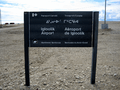
Currently displayed sign. Labeled as an airport of Northwest Territories as sign predates creation of Nunavut in 1999
-
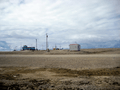
Igloolik Airport at a distance (blue building). A Canadian North airplane arrives, as All-terrain vehicles and trucks drive up to the airport.
References
- ↑ Canada Flight Supplement. Effective 0901Z 24 July 2014 to 0901Z 18 September 2014
- ↑ Total aircraft movements by class of operation
- ↑ Flight Schedule and Route Map.
- ↑ First Air Flight Schedule
- ↑ "C-FOOX Accident description". Aviation Safety Network. Retrieved 21 August 2010.
External links
- Past three hours METARs, SPECI and current TAFs for Igloolik Airport from Nav Canada as available.
| ||||||||||||||||||||||||||||||