Ifugao
| Ifugao | |||
|---|---|---|---|
| Province | |||
|
The Rice Terraces of the Philippine Cordilleras, a UNESCO World Heritage Site | |||
| |||
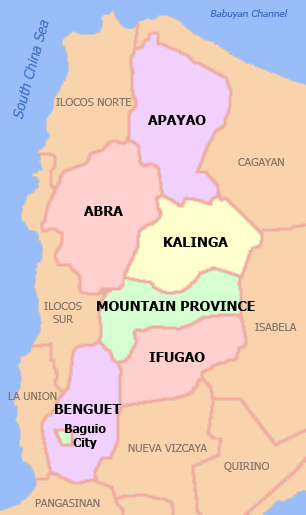
 Location in the Philippines | |||
| Coordinates: 16°50′N 121°10′E / 16.833°N 121.167°ECoordinates: 16°50′N 121°10′E / 16.833°N 121.167°E | |||
| Country | Philippines | ||
| Region | Cordillera Administrative Region (CAR) | ||
| Founded | June 18, 1966 | ||
| Capital | Lagawe | ||
| Government | |||
| • Type | Province of the Philippines | ||
| • Governor | Denis Habawel (Independent) | ||
| • Vice Governor | Pedro Mayam-o (LP) | ||
| Area[1] | |||
| • Total | 2,628.21 km2 (1,014.76 sq mi) | ||
| Area rank | 51st out of 81 | ||
| Population (2010)[2] | |||
| • Total | 191,078 | ||
| • Rank | 72nd out of 81 | ||
| • Density | 73/km2 (190/sq mi) | ||
| • Density rank | 74th out of 81 | ||
| Divisions | |||
| • Independent cities | 0 | ||
| • Component cities | 0 | ||
| • Municipalities | 11 | ||
| • Barangays | 175 | ||
| • Districts | Lone district of Ifugao | ||
| Time zone | PHT (UTC+8) | ||
| ZIP code | 3600 to 3610 | ||
| Dialing code | 74 | ||
| ISO 3166 code | PH-IFU | ||
| Spoken languages | Ifugao, Tuwali, Ayangan, Kalanguya, Ilocano, Tagalog, English | ||


Ifugao is a landlocked province of the Philippines in the Cordillera Administrative Region in Luzon. Its capital is Lagawe and borders Benguet to the west, Mountain Province to the north, Isabela to the east, and Nueva Vizcaya to the south.
The Rice Terraces of the Philippine Cordilleras and Banaue Rice Terraces are the main tourist attractions in the province. These 2000-year-old terraces were carved into the mountains, without the aid of machinery, they used their "bare" hands to provide level steps where the natives can plant rice. In 1995, they were declared as a UNESCO World Heritage Site.[3]
Etymology
Ifugao is named after the term "i-pugo" ("i" [from/people] and "pugo" [hill]), which translates to people of the hill.[4]
History
Spanish regime
During the Spanish occupation, Ifugao was under the jurisdiction of the province of Nueva Vizcaya.[5][6] In 1891, the Spanish government established Quiangan as a comandancia-politico-militar[7][8] for the Ifugao area.[9]
The Spanish occupation in the province ended with the outbreak of the Philippine Revolution.
American occupation
On August 18, 1908, Ifugao was separated from Nueva Vizcaya[10] and, along with Amburayan, Apayao, Benguet, Bontoc, Kalinga and Lepanto, was annexed to the newly-created Mountain Province established by the Philippine Commission with the enactment of Act No. 1876.[11][7][5]
World War II
Ifugao became the center of warfare in the last year of World War II when Gen. Tomoyuki Yamashita launched his last stand against the American and Philippine Commonwealth forces at Mount Napulawan. He informally surrendered to Captain Grisham of the 6th US Army in the Philippines based in Kiangan,[5] before he was flown to Camp John Hay where he formally surrendered.
Post-war era
On June 18, 1966, Republic Act No. 4695 was enacted, and Ifugao was converted into a regular province when the huge Mountain Province was split into four (the other three being Benguet, Mountain Province, and Kalinga-Apayao).[12][4] Ifugao and Kalinga-Apayao were placed under the jurisdiction of the Cagayan Valley region.[5][13]
On July 15, 1987, the Cordillera Administrative Region was established by then-President Corazon Aquino thru Executive Order 220, and Ifugao was made one of its provinces.[5][14][15]
In 1992, Republic Act No. 07173 was enacted, separating several barangays from Kiangan and constituting them under a new municipality known as Asipulo.[16][17]
Since 1992, the province has been observing every September 2 as “Victory Day”, commemorating the valor of Philippine war veterans and the surrender of General Tomoyuki Yamashita in the municipality of Kiangan on September 2, 1945.[18][19][20]
In 1995, the Batad Rice Terraces, Bangaan Rice Terraces (both in Banaue), Mayoyao Rice Terraces (in Mayoyao), Hungduan Rice Terraces (in Hungduan) and Nagacadan Rice Terraces (in Kiangan, Ifugao) were inscribed by UNESCO as a World Heritage Site under the collective name "Rice Terraces of the Philippine Cordilleras".[3]
Geography
Covering a total land area of 2,628.2 km², the province of Ifugao is located in a mountainous region characterized by rugged terrain, river valleys, and massive forests.
Administrative
Ifugao is divided into 11 municipalities, all of which belong a lone legislative district.[21][22]

| Seal | Municipality | Land area (km2)[21] |
Population (2010)[22] |
Pop. density (per km2) |
No. of barangays |
ZIP code | Income class[21] |
Location |
|---|---|---|---|---|---|---|---|---|
| |
||||||||
| Aguinaldo | 538.05 | 18,610 | 35 | 16 | 3606 | 2nd |  | |
| | Alfonso Lista (Potia) | 347.46 | 28,410 | 82 | 20 | 3608 | 3rd |  |
| | Asipulo | 182.87 | 14,403 | 79 | 9 | 3610 | 5th |  |
| Banaue | 191.20 | 22,365 | 120 | 18 | 3601 | 4th |  | |
| Hingyon | 62.02 | 9,795 | 160 | 12 | 3607 | 5th |  | |
| Hungduan | 260.30 | 9,933 | 38 | 9 | 3603 | 4th |  | |
| Kiangan | 200.00 | 15,837 | 79 | 14 | 3604 | 4th |  | |
| Lagawe † | 208.91 | 18,077 | 87 | 20 | 3600 | 4th |  | |
| | Lamut | 159.65 | 23,088 | 140 | 18 | 3605 | 4th |  |
| | Mayoyao | 238.05 | 16,413 | 69 | 27 | 3602 | 4th |  |
| | Tinoc | 239.70 | 14,147 | 59 | 12 | 3609 | 4th |  |
| | Ifugao Total | 2,628.21 | 191,078 | 73 | 175 | 3600 - 3610 | 3rd[21] | |
- *Italicized names are former names.
Barangays
The 11 municipalities of the province comprise a total of 175 barangays, with Santa Maria in Alfonso Lista (Potia) as the most populous in 2010, and Banga in Lagawe as the least.[22][21]
Demographics
| Population census of Ifugao | ||
|---|---|---|
| Year | Pop. | ±% p.a. |
| 1990 | 147,281 | — |
| 1995 | 149,598 | +0.29% |
| 2000 | 161,623 | +1.67% |
| 2007 | 180,711 | +1.55% |
| 2010 | 191,078 | +2.05% |
| Source: National Statistics Office[2][23] | ||
Based on the 2000 census survey, Ifugao are the majority of the province population with them comprising about 67.9% of the population. other ethnic groups living in the province are the Ilocanos 13.7%, Kalahan 8.6%, Ayangan 6.2% 0.6%.[24] [25]
The people of Ifugao province are called Ifugaos, but mistakenly called by non-Cordilleran as Igorots. Ifugaos, despite the similarities in some cultural traditions and practices, are considered a separate ethnic group from Igorots.
As of today`s total number of population of Tinguian in the province of Ifugao is 2,609. (source: National Statistics Office)
Rice culture

Ifugao culture revolves around rice, which is considered a prestige crop. There is an elaborate and complex array of rice culture feasts inextricably linked with taboos and intricate agricultural rites, from rice cultivation to rice consumption. Harvest season calls for grandiose thanksgiving feasts, while the concluding harvest rites "tungo" or "tungul" (the day of rest) entail a strict taboo of any agricultural work. Partaking of the rice wine (bayah), rice cakes, and 'moma' (mixture of several herbs, powdered snail shell and betel nut/ arecoline: and acts as a chewing gum to the Ifugaos) is an indelible practice during the festivities and ritual activitiess. their retual and Agricultural terracing is their principal means of livelihood along with farming. Their social status is measured by the number of rice field granaries, family heirlooms, gold earrings, carabaos (water buffaloes), as well as, prestige conferred through time and tradition. The more affluent, known as kadangyan were usually generous by nature, giving rice to poor neighbors in time of food shortage(s) and/or hardship(s). Furthermore, their culture was known for their legal system, using one of the world's most extensive oral legal traditions specifying the offense depending on the use of custom law; trial by elders (influenced in part by public opinion); or trial by ordeal. The wealthy were subjected to greater fines than the poor.

Untouched by the influences of Spanish colonialism, Ifugao culture value kinship, family ties, religious and cultural beliefs. They're unique among all ethnic groups in the mountain province, not only for their interesting customs and traditions but also for their narrative literature such as the hudhud, an epic dealing with hero ancestors sung in a poetic manner. Another feature unique to the Ifugao is their woodcarving art, most notably the carved granary guardians bului and the prestige bench of the upper class, the hagabi. Their textiles renowned for their sheer beauty, colorful blankets and clothing woven on looms. Houses were well-built, characterized by as a square with wooden floors, windowless walls, and pyramidal thatch roofs. Elevated from the ground by four sturdy tree trunks, they feature removable staircases that were hoisted up at night to prevent entry by enemies and/or wild animals. Lastly, their attire remain traditional for male Ifugaos, donning the wanno or g-string; there are six types of wanno which are used depending on the occasion or the man's social status. Ifugao women, on the contrary, wear tapis, a wraparound skirt; there are five kinds of skirts worn, depending on the occasion and/or status of the woman/girl.
References
- ↑ "List of Provinces". PSGC Interactive. Makati City, Philippines: National Statistical Coordination Board. Retrieved 20 December 2013.
- ↑ 2.0 2.1 "Total Population by Province, City, Municipality and Barangay: as of May 1, 2010" (PDF). 2010 Census of Population and Housing. National Statistics Office. Retrieved 20 December 2013.
- ↑ 3.0 3.1 "Rice Terraces of the Philippine Cordilleras". UNESCO World Heritage Centre. Retrieved 2 January 2015.
- ↑ 4.0 4.1 "Facts & Figures: Ifugao Province". Philippine Statistics Authority - National Statistical Coordination Board. Department of the Interior and Local Government - Cordillera Administrative Region. Retrieved 2 January 2015.
- ↑ 5.0 5.1 5.2 5.3 5.4 Lancion, Jr., Conrado M.; de Guzman, Rey (cartography) (1995). "The Provinces". Fast Facts about Philippine Provinces (The 2000 Millenium ed.). Makati, Metro Manila: Tahanan Books. pp. 76–77. ISBN 971-630-037-9. Retrieved 16 January 2015.
- ↑ "Natural Attractions found in Atok". Province of Benguet. Retrieved 13 August 2013.
- ↑ 7.0 7.1 Worcester, Dean C.; Philippine Commission (1908). Seventh Annual Report of the Secretary of the Interior to the Philippine Commission for the Fiscal Year Ended June 30, 1908. Manila: U.S. Government Printing Office. pp. 17–19. Archived from the original (DIGITIZED BY GOOGLE ON 23 NOV 2005 (ORIGINAL FILE FROM THE UNIVERSITY OF MICHIGAN)) on 23 Nov 2005. Retrieved 2 January 2015.
Google Books link
- ↑ Keesing, Felix Maxwell; Keesing, Marie Margaret; Keesing, Marie Martin; Institute of Pacific Relations (contributor); International Research Committee (contributor) (1934). Taming Philippine Headhunters: A Study of Government and of Cultural Change in Northern Luzon. Stanford University Press. p. 69. ISBN 9780804721103. Retrieved 2 January 2015.
- ↑ Felix M., Keesing (1962). "The Upper Cagayan Area". The Ethnohistory of Northern Luzon. Stanford University Press. p. 297. ISBN 9780804700498. Retrieved 2 January 2015.
- ↑ National Historical Institute (Philippines) [contributor] (1978). Kasaysayan, Volume 3, Issues 1-4 (DIGITIZED BY GOOGLE ON 26 SEP 2009). National Historical Institute. p. 16. Retrieved 2 January 2015.
(Original file from the University of Michigan)
- ↑ Ingles, Raul Rafael (2008). 1908 :The Way it Really was : Historical Journal for the UP Centennial, 1908-2008. Diliman, Quezon City: University of the Philippines Press. p. 330. ISBN 9715425801. Retrieved 2 January 2015.
- ↑ "Republic Act No. 4695: An Act Creating the Provinces of Benguet, Mountain Province, Ifugao and Kalinga-Apayao". Chan Robles Virtual Law Library. Retrieved 18 September 2014.
- ↑ "Historical Background". Provincial Government of Apayao. 15 April 2013. Retrieved 3 January 2015.
- ↑ "Regional Profile: Cordillera Administrative Region (CAR)". CountrySTAT Philippines. Retrieved 18 September 2014.
- ↑ "The Cordillera Administrative Region (CAR)". Department of Agriculture. Retrieved 18 September 2014.
- ↑ "Republic Act No. 07173: An Act Creating the Municipality of Asipulo in the Province of Ifugao" (PDF). House of Representatives of the Philippines. Retrieved 2 January 2015.
- ↑ "Municipality of Asipulo, Ifugao". Department of the Interior and Local Government - Cordillera Administrative Region. 29 April 2013. Retrieved 2 January 2015.
- ↑ "PVAO recognizes Ifugao town for promoting valor and heroism of veterans". Philippine Information Agency. Philippine Information Agency - Cordillera Administrative Region. 9 December 2014. Retrieved 2 January 2015.
- ↑ "Re-enactment of WWII episodes steal show during Victory Day Celebration in Ifugao". Philippine Information Agency. 3 September 2012. Retrieved 2 January 2015.
- ↑ Bitog, Rubyloida (18 August 2012). "Ifugaos to mark liberation". Sun.Star Baguio. Retrieved 2 January 2015.
- ↑ 21.0 21.1 21.2 21.3 21.4 "Province: Ifugao". Philippine Statistics Authority - National Statistical Coordination Board. Retrieved 30 December 2014.
- ↑ 22.0 22.1 22.2 "2010 Census of Population and Housing: Population Counts - Cordillera Administrative Region" (PDF). National Statistics Office, April 4, 2012. Retrieved 16 November 2014.
- ↑ "Population and Annual Growth Rates for The Philippines and Its Regions, Provinces, and Highly Urbanized Cities" (PDF). 2010 Census and Housing Population. National Statistics Office. Retrieved 26 August 2013.
- ↑ "Ifugao: Five Economically Active Persons Support Four Dependents". National Statistics Office. National Statistics Office. 4 March 2002. Archived from the original on 5 March 2012. Retrieved 2 January 2015.
- ↑ http://www.census.gov.ph/data/pressrelease/2002/pr0228tx.html
| Wikimedia Commons has media related to Ifugao. |
 |
Mountain Province | | ||
| Benguet | |
Isabela | ||
| ||||
| | ||||
| Nueva Vizcaya |
| ||||||||||||||
| ||||||||||||||||||||||||||||||||||


| |||||||||||||||||||||||||||||||||||||||||||||