Icknield Port Loop
| Icknield Port Loop | |
|---|---|
|
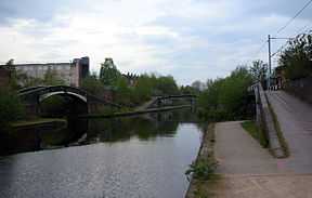
Rotton Park Junction — the Icknield Port Loop runs through the bridge to the left | |
| Specifications | |
| Maximum height above sea level |
453 ft (138 m) (Birmingham Level) |
| Status | Open |
| Navigation authority | Canal and River Trust |
| History | |
| Date completed | 1769 |

The Icknield Port Loop (originally called the Rotton Park Loop)[1] is a 0.6-mile (1 km) section of the eighteenth-century Old BCN Main Line canal in Birmingham, England, about 2 miles (3 km) west of the city centre, which opened to traffic on 6 November 1769, and was bypassed in September 1827 by a straight 550-yard (500 m) section of the New BCN Main Line.[1] Most of the 56 acres (23 ha) hectares of enclosed land now being derelict, the canal serves only the British Waterways maintenance depot at Icknield Port and conveys water from Edgbaston Reservoir to the BCN Main Line. There is no pedestrian or vehicular access. Icknield Port (Loop) takes its name from the Roman Icknield Street which passed nearby, though its exact route is unknown.
Birmingham City Council has plans for the regeneration of the area, including moorings, 1,150 new homes, shops, park and playground, and a ten-storey hotel.[2][3]
| Point | Coordinates (Links to map resources) |
OS Grid Ref | Notes |
|---|---|---|---|
| Sandy Turn Junction | 52°28′58″N 1°55′33″W / 52.4827°N 1.9259°W | SP050872 | BCN Old and New Lines meet |
| Icknield Port | 52°28′52″N 1°55′59″W / 52.4810°N 1.9330°W | SP046870 | British Waterways maintenance depot |
| Rotton Park Junction | 52°29′03″N 1°55′45″W / 52.4843°N 1.9291°W | SP048874 | BCN Old and New Lines cross |
See also
References
- ↑ 1.0 1.1 Hadfield, Charles. Canals of the West Midlands. Newton Abbott: David & Charles.
- ↑ "Icknield Port Loop". Urbed. Retrieved 2012-01-26.
- ↑ "Regeneration Plans for new canal district", Birmingham News (Birmingham, UK), p.1, 9 February 2012.
External links
| Wikimedia Commons has media related to Icknield Port Loop. |