Ichuña District
| Ichuña | |
|---|---|
| District | |
|
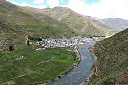
Ichuña | |
| Country |
|
| Region | Moquegua |
| Province | General Sánchez Cerro |
| Founded | January 2, 1857 |
| Capital | Ichuña |
| Government | |
| • Mayor | Melecio Eleusipo Flores Ventura |
| Area | |
| • Total | 1,017.74 km2 (392.95 sq mi) |
| Elevation | 3,756 m (12,323 ft) |
| Population (2005 census) | |
| • Total | 3,782 |
| • Density | 3.7/km2 (9.6/sq mi) |
| Time zone | PET (UTC-5) |
| UBIGEO | 180204 |
Ichuña District is one of eleven districts of the province General Sánchez Cerro in Peru.[1]
Ethnic groups
The people in the district are mainly indigenous citizens of Quechua descent. Quechua is the language which the majority of the population (79.61%) learnt to speak in childhood, 12.86% of the residents started speaking using the Spanish language (2007 Peru Census).[2]
Geography
Some of the highest peaks of the district are listed below:[3]
|
See also
References
- ↑ (Spanish) Instituto Nacional de Estadística e Informática. Banco de Información Distrital. Retrieved April 11, 2008.
- ↑ inei.gob.pe INEI, Peru, Censos Nacionales 2007, Frequencias: Preguntas de Población: Idioma o lengua con el que aprendió hablar (in Spanish)
- ↑ escale.minedu.gob.pe - UGEL map of the General Sánchez Cerro Province (Tacna Region)
| ||||||||||||||