Ichinoseki, Iwate
| Ichinoseki 一関市 | |||
|---|---|---|---|
| City | |||
|
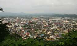
Ichinoseki Skyline | |||
| |||
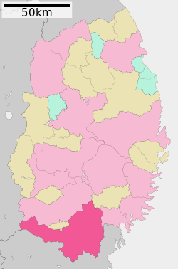 Location of Ichinoseki in Iwate Prefecture | |||
 Ichinoseki
| |||
| Coordinates: 38°55′N 141°08′E / 38.917°N 141.133°ECoordinates: 38°55′N 141°08′E / 38.917°N 141.133°E | |||
| Country | Japan | ||
| Region | Tōhoku | ||
| Prefecture | Iwate | ||
| Area | |||
| • Total | 1,256.25 km2 (485.04 sq mi) | ||
| Population (February 2014) | |||
| • Total | 123,252 | ||
| • Density | 98.1/km2 (254/sq mi) | ||
| Time zone | Japan Standard Time (UTC+9) | ||
| - Tree | Japanese beech | ||
| - Flower | Rapeseed | ||
| - Bird | Japanese Bush-warbler | ||
| Phone number | 0191-21-2111 | ||
| Address |
7-2 Takeyama-chō, Ichinoseki-shi, Iwate-ken 021-8501 | ||
| Website | Official website | ||


Ichinoseki (一関市 Ichinoseki-shi) is a city located in Iwate Prefecture, Japan. As of February 2014, the city had an estimated population of 123,252 and a population density of 98.1 persons per km², with the total area of 1,256.25 km². It is currently the second largest city by population in the prefecture, after Morioka.
Geography
The City of Ichinoseki is located in the far south region of Iwate Prefecture, bordered by Miyagi Prefecture to the south.
Neighboring municipalities
- Iwate Prefecture
- Miyagi Prefecture
- Akita Prefecture
Demographics
Due to factories belonging to large Japanese companies such as Sony and NEC being located in the industrial parkland zone of Ichinoseki, the city has a sizable population of Brazilian workers. The agricultural makeup of the city outside the centre is mostly composed of farmers, leading to an influx of Chinese and Filipino immigrants due to marriage. As a result, Ichinoseki has a varied ethnic makeup, although the newcomers still remain a small minority.
History
The area of present-day Ichinoseki was part of ancient Mutsu Province, and has been settled since at least the Japanese Paleolithic period. The area was inhabited by the Emishi people, and came under the control of the Yamato dynasty during the early Heian period. During the Heian period, it was controlled by the Abe clan, followed by the Northern Fujiwara clan of Hiraizumi. During the Sengoku period, the area was dominated by various samurai clans before coming under the control of the Date clan during the Edo period, who ruled Sendai Domain under the Tokugawa shogunate.
The town of Ichinoseki was established within Nishiiwai District, Iwate on April 1, 1889 with the establishment of the municipality system.
- April 1, 1948 - The city of Ichinoseki (1st generation) was founded by the merger of the towns of Ichinoseki and Yamame with the villages of Mataki and Nakasato.
- January 1, 1955 - The city of Ichinoseki (1st generation) absorbed the villages of Genbi, Hagisho, Maikawa, and Yasakae to form the new city of Ichinoseki (2nd generation)
- September 1, 1956 - Due to a boundary adjustment, the city absorbed parts of the town of Hiraizumi.
- May 1, 1964 - Due to a boundary adjustment, the city absorbed more of the town of Hiraizumi.
- September 20, 2005 - the towns of Daitō, Higashiyama and Senmaya, the villages of Kawasaki and Murone (all from Higashiiwai District), and the town of Hanaizumi (from Nishiiwai District) were merged with the city of Ichinoseki (2nd generation) to create the new and expanded city (3rd generation). This creation approximately doubled the old city's population and nearly tripled its size.
- September 26, 2011 - the town of Fujisawa (also from Higashiiwai District) was merged into Ichinoseki. Higashiiwai District was dissolved as a result of this merger.
Education
Special schools
Elementary School
|
|
|
Junior High School
|
|
High school
- Ichinoseki Gakuin High School (一関学院高等学校)
- Ichinoseki Shuko High School (一関修紅高等学校) (also has a preschool and a university)
- Ichinoseki No. 1 High School (岩手県立一関第一高等学校)
- Ichinoseki No. 2 High School (岩手県立一関第二高等学校)
- Hanaizumi High School (岩手県立花泉高等学校)
- Daito High School (岩手県立大東高等学校)
- Senmaya High School (岩手県立千厩高等学校)
- Ichinoseki Tech High School (岩手県立一関工業高等学校)
Kosen
- Ichinoseki National College of Technology (一関工業高等専門学校)
Junior College
- Shuko Junior College (修紅短期大学)
Transportation
Railway
- East Japan Railway Company (JR East) – Tōhoku Shinkansen
- East Japan Railway Company (JR East) – Tōhoku Main Line
- Ichinoseki - Yushima - Hanaizumi - Shimizuhara - Arikabe - Ichinoseki - Yamanome
- East Japan Railway Company (JR East) – Ōfunato Line
- Ichinoseki - Mataki - Rikuchū-Kanzaki - Iwanoshita - Rikuchū-Matsukawa - Geibikei - Shibajuku - Surisawa - Senmaya - Konashi - Yagoshi - Orikabe - Niitsuki
Highway
- Tōhoku Expressway – Ichinoseki IC, HIraizumi-mae IC
- Japan National Route 4
- Japan National Route 284 – Ichinoseki Road Station
- Japan National Route 342 – Genbikei Road Station
- Japan National Route 343
- Japan National Route 346
- Japan National Route 456
- Japan National Route 457
Local attractions
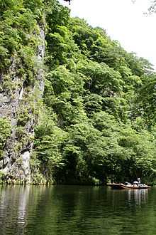
Ichinoseki is in close proximity to the historically significant site of Hiraizumi, which lies adjacent to the mid-northern border of the city. Ichinoseki station is a convenient transit hub for excursions to Hiraizumi, with access to Tōhoku Shinkansen and local rail lines. Tsuriyama Park lies near the center of the original city of Ichinoseki. Atop Tsuriyama Park a panorama of the City of Ichinoseki is accessible. Geibikei is a dramatic river gorge which offers rides in traditional flat-bottomed boats, navigated by singing "gondoliers". Alternatively, Genbikei is another popular river area with naturally carved cliffs. The Hondera Farm Village has been designated an Important Cultural Landscape.[1]
Sister Cities/Friendship Cities
Within Japan
- Miharu (Tamura District, Fukushima Prefecture)
- Signed between the former city of Ichinoseki on August 8, 1987
- Kesennuma (Miyagi Prefecture)
- Signed between the former cities of Ichinoseki and Kesennuma on May 1, 1997
- Signed between the former city of Kesennuma and former town of Murone on May 8, 2003
- Tanabe (Wakayama Prefecture)
- Signed between the former village of Murone and the town of Hongu on August 8, 1987
- Yoshikawa (Saitama Prefecture)
- Signed by the former village of Murone on April 15, 1997
Noted people from Ichinoseki
- Ayaka Komatsu – model/actress
- Keiko Fuji – singer/actress
- Shota Kimura (baseball) – baseball player
- Miyagiyama Fukumatsu – sumo wrestler
- Masato Onodera – professional wrestler
- Takahira Kogorō - diplomat
References
- ↑ "Database of Registered National Cultural Properties". Agency for Cultural Affairs. Retrieved 29 April 2011.
External links
![]() Media related to Ichinoseki, Iwate at Wikimedia Commons
Media related to Ichinoseki, Iwate at Wikimedia Commons
- Official website (Japanese)