Iceberg Peak (Montana)
| Iceberg Peak | |
|---|---|
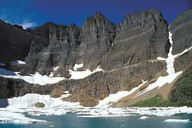 Iceberg Peak above Iceberg lake | |
| Elevation | 9,145 ft (2,787 m)[1] |
| Prominence | 905 ft (276 m)[2] |
| Location | |
| Location | Glacier County, Montana, Flathead County, Montana, U.S. |
| Range | Lewis Range |
| Coordinates | 48°48′52″N 113°45′36″W / 48.81444°N 113.76000°WCoordinates: 48°48′52″N 113°45′36″W / 48.81444°N 113.76000°W[3] |
| Topo map | USGS Ahern Pass |
Iceberg Peak (9,145 feet (2,787 m)) is located in the Lewis Range, Glacier National Park in the U.S. state of Montana.[2] Iceberg Peak rises more than 3,000 feet (910 m) above Iceberg Lake and is considered a difficult climb due to the steepness and exposure climbers must endure.[4]
See also
- Mountains and mountain ranges of Glacier National Park (U.S.)
References
- ↑ "Iceberg Peak, Glacier National Park, Montana" (Map). My Topo (USGS Quads). Retrieved 2010-05-02.
- ↑ 2.0 2.1 "Iceberg Peak, Montana". Peakbagger.com. Retrieved 2010-05-02.
- ↑ "Iceberg Peak". Geographic Names Information System. United States Geological Survey. Retrieved 2010-09-26.
- ↑ "Iceberg Peak". SummitPost. Retrieved 2010-05-02.