Iakora District
Not to be confused with Iakora, a town and commune with the same name.
| Iakora District | |
|---|---|
| District | |
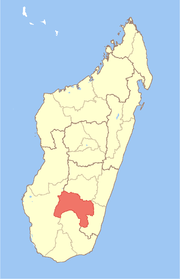
 Location in Madagascar | |
| Coordinates: 23°06′S 46°39′E / 23.100°S 46.650°E | |
| Country |
|
| Region | Ihorombe |
| Area[1] | |
| • Total | 4,633 km2 (1,789 sq mi) |
| Population (2001)[1] | |
| • Total | 29,987 |
| • Density | 6.5/km2 (17/sq mi) |
| Time zone | EAT (UTC3) |
Iakora is a district in south-eastern Madagascar. It is a part of Ihorombe Region and borders the districts of Ihosy in northwest, Ivohibe in northeast, Midongy Sud in east, Befotaka in south and Betroka in west. The area is 4,633 km2 (1,789 sq mi) and the population was 29,987 in 2001.[1] The district is further divided into 3 communes.
References and notes
- ↑ 1.0 1.1 1.2 "Madagascar Administrative units". GeoHive. Retrieved 2008-04-28.
Coordinates: 23°06′S 46°39′E / 23.100°S 46.650°E
| ||||||||||||||||