Hvar (city)
| Hvar | |||
|---|---|---|---|
| City | |||
| City of Hvar Grad Hvar | |||
|
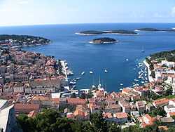
Port of Hvar | |||
| |||
 Hvar Location of Hvar (city) in Croatia | |||
 Hvar Location of Hvar (city) in Split-Dalmatia County | |||
| Coordinates: 43°10′N 16°27′E / 43.167°N 16.450°E | |||
| Country |
| ||
| County | Split-Dalmatia County | ||
| Island | Hvar | ||
| Government | |||
| • Mayor | Pjerino Bebić | ||
| Area | |||
| • Total | 75.5 km2 (29.2 sq mi) | ||
| Population (2001) | |||
| • Total | 4,138 | ||
| • Metro density | 55/km2 (140/sq mi) | ||
| Time zone | CET (UTC+1) | ||
| • Summer (DST) | CEST (UTC+2) | ||
| Postal code | 21450 | ||
| Area code(s) | 021 | ||
| Website | hvar.hr | ||


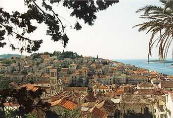
Hvar (local Croatian dialect: Hvor or For, Greek: Pharos, Latin: Pharina, Italian: Lesina) is a city and port on the island of Hvar, part of Split-Dalmatia County, Croatia. The municipality has a population of 4,138 (2001) while the city itself is inhabited by 3,672 people, making it the largest settlement on the island of Hvar.[1] It is situated on a bay in the south coast of the island, opposite from the other nearby towns of Stari Grad and Jelsa.
The city of Hvar has a long and distinguished history as center for trade and culture in the Adriatic. An independent commune within the Venetian Empire during the 13th to 18th centuries, it was an important naval base with a strong fortress above, encircling town walls and protected port.[2] Cultural life thrived as prosperity grew, and Hvar is the site of one of the oldest surviving theatres in Europe, opened in 1612.[3] The seven-century old walls still survive, as do many of the noble houses and public buildings from 15th - 17th centuries.
By the 19th century, the port of Hvar was no longer a military base, and The Hygienic Society of Hvar (Higijeničko društvo u Hvaru) took the economy of the city and the island in a new direction. As one of the earliest "tourist boards" in Europe, it was founded in 1868 with the purpose of providing "good care for visitors". Today, the city has a variety of hotels, galleries, museums, and exhibitions, including the Arsenal, Loggia, the Croatian Institute, and the Hvar Heritage Museum with its art and archaeological collections.[4]
The port of Hvar, set in a picturesque natural bay, with the Pakleni Otoci island chain protecting it to the south, is a safe haven for boats year round. The city is a popular port of call for yachts sailing around the Adriatic, especially in the summer months. There are regular catamaran ferry services from the port between Hvar and Split, Brač, Korčula, Lastovo, and Vis.[5]
Municipality
The municipality of Hvar covers 7,535 ha, including the town itself and the settlements of Brusje (pop. 206), Velo Grablje (pop. 21), Milna (pop. 90) and Sveta Nedilja (pop. 148). The old settlements of Malo Grablje and Zaraće are no longer inhabited. Population figures from the 2001 Census.[1]
Geography

The town is located in a small bay on the south coast of the island of Hvar, towards the western end. The surrounding land is karst hillside, rising steeply from the Adriatic Sea. The rocks in the area are porous, mainly limestone and dolomite, so ground water is scarce. However there is some agriculture where the terrain is sufficiently accessible, and can be irrigated, such as olive groves, vineyards, lavender, rosemary.
The mountain range that stretches the length of the island acts as an effective barrier between Hvar town and the settlements to the north. In centuries past, it would have taken several hours to walk overland, or sail around the coast. The modern Stari Grad to Hvar road, with its new tunnel (opened in 2000),[6] now provides quick and easy access between the north and south.
The coastline is mostly steep and indented, with small gravel beaches in the bays. The Pakleni Otoci and the island of Galešnik at the entrance to the port of Hvar are protected landscape areas.
Climate
| Hvar (Town of Hvar) | ||||||||||||||||||||||||||||||||||||||||||||||||||||||||||||
|---|---|---|---|---|---|---|---|---|---|---|---|---|---|---|---|---|---|---|---|---|---|---|---|---|---|---|---|---|---|---|---|---|---|---|---|---|---|---|---|---|---|---|---|---|---|---|---|---|---|---|---|---|---|---|---|---|---|---|---|---|
| Climate chart (explanation) | ||||||||||||||||||||||||||||||||||||||||||||||||||||||||||||
| ||||||||||||||||||||||||||||||||||||||||||||||||||||||||||||
| ||||||||||||||||||||||||||||||||||||||||||||||||||||||||||||
Hvar town enjoys a sunny Mediterranean climate, typical of the southern Adriatic, with mild wet winters and hot dry summers. For the months of June to September, the average temperature is higher than 20 °C (68 °F), dropping below 10 °C (50 °F) in just two months of the year (January and February). Winter days see high between 10 to 18 °C (50 to 64 °F) and lows from 4 to 10 °C (39 to 50 °F). Daytime high temperatures in the summer months range from 27 to 34 °C (81 to 93 °F) and from 18 to 25 °C (64 to 77 °F) for the overnight lows. During the summer, the westerly mistral wind blows through the Pakleni channel, providing welcome cooling during the day. Rain is rare here during spring and summer, though plentiful in autumn and winter months. Light snow occurs on average once every ten years, however, it does not stay on the ground long.
The average monthly temperature of the sea, from June through October, is 20 °C (68 °F). It is not unusual for the sea temperature to reach more than 27 °C (81 °F).[4] The sea is always warmer than the air, except during the summer months. The current usually comes from the south-east.
| Climate data for Hvar | |||||||||||||
|---|---|---|---|---|---|---|---|---|---|---|---|---|---|
| Month | Jan | Feb | Mar | Apr | May | Jun | Jul | Aug | Sep | Oct | Nov | Dec | Year |
| Record high °C (°F) | 19.6 (67.3) |
23.4 (74.1) |
24.0 (75.2) |
27.8 (82) |
33.0 (91.4) |
37.0 (98.6) |
37.5 (99.5) |
37.7 (99.9) |
34.4 (93.9) |
31.5 (88.7) |
25.7 (78.3) |
20.6 (69.1) |
37.7 (99.9) |
| Average high °C (°F) | 12.6 (54.7) |
13.0 (55.4) |
14.9 (58.8) |
17.7 (63.9) |
22.3 (72.1) |
26.4 (79.5) |
29.5 (85.1) |
29.5 (85.1) |
26.0 (78.8) |
21.8 (71.2) |
16.8 (62.2) |
13.7 (56.7) |
20.35 (68.63) |
| Daily mean °C (°F) | 9.1 (48.4) |
9.2 (48.6) |
11.1 (52) |
14.0 (57.2) |
18.5 (65.3) |
22.3 (72.1) |
25.0 (77) |
24.8 (76.6) |
21.5 (70.7) |
17.7 (63.9) |
13.3 (55.9) |
10.5 (50.9) |
16.42 (61.55) |
| Average low °C (°F) | 5.9 (42.6) |
5.9 (42.6) |
7.7 (45.9) |
10.5 (50.9) |
14.7 (58.5) |
18.3 (64.9) |
20.9 (69.6) |
20.8 (69.4) |
17.7 (63.9) |
14.3 (57.7) |
10.1 (50.2) |
7.2 (45) |
12.83 (55.1) |
| Record low °C (°F) | −4.6 (23.7) |
−4.7 (23.5) |
−4.4 (24.1) |
2.7 (36.9) |
6.6 (43.9) |
10.6 (51.1) |
14.1 (57.4) |
12.1 (53.8) |
10.0 (50) |
4.9 (40.8) |
−0.2 (31.6) |
−3.1 (26.4) |
−4.7 (23.5) |
| Average precipitation mm (inches) | 68.4 (2.693) |
55.7 (2.193) |
62.7 (2.469) |
54.1 (2.13) |
46.7 (1.839) |
34.4 (1.354) |
26.4 (1.039) |
45.2 (1.78) |
63.7 (2.508) |
79.3 (3.122) |
94.0 (3.701) |
83.2 (3.276) |
713.8 (28.104) |
| Avg. rainy days | 7.4 | 6.8 | 7.4 | 7.0 | 5.2 | 4.4 | 2.3 | 3.4 | 5.2 | 7.2 | 8.5 | 8.0 | 72.8 |
| Mean monthly sunshine hours | 131.9 | 148.9 | 193.8 | 230.6 | 291.5 | 323.7 | 370.3 | 340.3 | 258.8 | 204.1 | 130.2 | 116.9 | 2,741 |
| Source: National Meteorological and Hydrological Service (Croatia) [7] | |||||||||||||
History
The earliest known settlement on the site of today's Hvar town was Illyrian,[8] lying on the hill slopes to the north side of the town square, which was then a small bay that came up to where the cathedral now stands. On the site of the present Spanish Fortress stood a hillfort, the importance of which can be seen in the pottery from the site, indicating long distance trade from the eighth century B.C. onwards.[9]
The ancient Greeks founded the settlement of Faros (384 BC) on the north of the island, from where they could control the fertile agricultural area, now known as the Stari Grad Plain. It has been proposed[10] that there was concurrently a second Greek settlement called Heraclea, on the site of today's Hvar town.
With the arrival of the Ancient Romans around 2nd century BC, settlement on the island was expanded. Colonisation was mainly rural, based around Roman villas (villa rusticae). During the 7th–8th centuries, the Slavs arrived on the island. At this time, life on the coast was not safe due to raiding pirates, and the inhabitants moved inland.[9] By the Medieval period, the population was gathered in villages well away from the coast for safety.[2]

Following this unsettled period, the islanders asked the Venetian Empire for protection (1278). As part of the agreement, the southern settlement of Hvar was to be expanded and fortified as a safe base for the Venetian fleet. As the new administrative centre, the town assumed the name of Hvar, and the ancient Greek town became known as Stari Grad (literally Old Town). Hvar became the centre of the independent commune government, the residence of the prince, and the base of the new diocese (consisting of Hvar, and the neighbouring islands of Brač, and Vis). The Venetians commissioned the construction of a new fortress, town walls, public buildings, and with the new prosperity, villages were gradually established along the nearby coastline.
By the 15th century, the town had become too confined within the old walls, so settlement extended to the hill to the south. The medieval town was bounded to the east by the cathedral and to the west by the Arsenal, the Governor's Palace and marina. During this time, Hvar was the centre of the economic, political and cultural life on the island, and played an important role in Venetian shipping.
The 16th century was a return to more unsettled times, with persistent conflicts between the nobles and citizens, and repeated attacks from the Ottoman Empire, now occupying the mainland. In 1571 Hvar was sacked by the Turkish fleet on its way to the Battle of Lepanto, and only the fortress saved the townspeople. Just as the town was being rebuilt, it suffered further damage in 1579 as lightning struck the gunpowder magazine in the fortress.[2] Many of today's public buildings in Hvar date from the reconstruction following the explosion.
In 1776, the Venetians moved their naval base to Kotor on the mainland, and the town of Hvar went into a decline.[3] After a brief period under the French Empire, Hvar came under the Austrian Habsburg Empire in the early part of the 19th century, a period of exceptional economic and cultural life for the town. In 1868, "The Hygienic Association of Hvar" was founded, to promote the development of tourist services.[2]

Economy
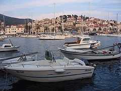
The town of Hvar is first and foremost a maritime port. Its location at the center of shipping routes in the Adriatic - both east-west and north-south - make it an ideal base for operations. In previous times, the fleets were the Venetian navy, or merchant traders from round the Mediterranean, North Africa and the Black Sea, even as far afield as up the Atlantic coast. Nowadays, the fleets are yachts, from sailboat charters to high-end luxury cruisers. The marina hosts a number of events year-round, including a new year ragatta.
Hvar is a popular destination for holidaymakers, especially during the summer season. There are a number of hotels in town, art galleries, museums, theatres, street cafes, and night clubs.
Culture
Hvar has a rich cultural tradition. Along with independent Dubrovnik, Hvar was an important centre of early Croatian literature, as well as for architecture, sculpture, painting and music. Well-known Croatian cultural figures such as Hanibal Lucić, Petar Hektorović, Vinko Pribojević, Mikša Pelegrinović, Martin Benetović and Marin Gazarović lived and worked on Hvar in the 16th and 17th centuries.[8] The oldest recorded performances were ecclesiastical pageants, such as the Pageant of St. Lovrinac (Laurence) the Martyr, from the 15th century. In the early 16th century Hanibal Lučić wrote Robinja (The Slave Girl), the first piece of Croatian drama.[3] Benetović's comedies followed, then the secular and ecclesiastical pageants of Marin Gazarović, and other works. Hvar's Theatre is one of the oldest in Europe, built in 1612. A lively theatrical tradition continued into the 19th century, especially at carnival time, when musical and theatrical performances were put on and masquerades (or cavalchins) organized. Many national and international actors and musicians have performed here over the years, and continue to do so.
Cultural and artistic events within the Hvar Summer Festival take place throughout the summer, from late June to late September. These events include classical music concerts performed by national and international artists, and performances by amateur groups from Hvar. Performances are given nearly every day in a number of venues around the town.[4]
The Gallery of Modern Art in Hvar[8] is located in the Arsenal building, in the lobby of the historic Theatre of Hvar. The permanent display contains the most valuable paintings, sculptures and prints from the collection, and temporary exhibitions are organised within the Museum project Summer of Fine Arts in Hvar. Other galleries, such as Lođa, Zvijezda Mora, Anuncijata, and Skorpion also host special exhibitions, and museums offer archaeological and historical displays.
The Hvar branch of the Croatian Institute has regularly organised cultural and artistic events, classical music concerts, exhibitions (Hvar Visual Arts Moment) and lectures by well-known Croatian artists and scientists. These events usually take place in the last week of July.[4]
Hvar town is a protected Cultural Heritage area, as are the rural areas of Velo Grablje, Malo Grablje and Zaraće. In addition, there are five archaeological sites in the area: the hydro-archaeological site of Palmižana, villa rustica Soline, the prehistoric site of Vira, and the prehistoric Lompić fort in the Gračišće Bay.[11]
Architecture

Hvar Town is encircled on its land-side by protective walls, and overlooked by two massive fortresses set on the hills above. The fortifications were commissioned by the Venetians in 1278, to create a safe haven for their fleet, and have been expanded in the centuries since. Within the walls, the public buildings and palaces combine Venetian architectural style, with a distinct local flavour in materials and workmanship. Much of the old town survives intact, in both layout and architecture, though more modern housing has developed in the surrounding areas.
The town walls date from the 13th century and, with later additions and renovations, stretch from the fortress down to the square where they join the third wall in an east-west direction. This wall is practically camouflaged by a series of patrician houses built into it. The walls are interspersed with four-cornered side towers, the construction of which lasted, with essential repairs, from the 13th to the 16th century. The current fortress Fortica, also known as Tvrđava Španjola (Spanish Fort) was constructed following the gunpowder explosion in 1579 which devastated the old fortress.[2] Today, the fortress includes a modern tourist complex, and provides a superb view of the town and its surroundings. In 1811, during the rule of the Napoleonic Empire, a second fortress Trđava Napoleon was constructed on the higher hill to the northeast. The site now also houses an observatory.
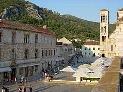
At the heart of the town lies the Pjaca (Piazza), leading from the waterfront to the Cathedral. This town square is the largest in Dalmatia at 4,500 m2 (48,437.60 sq ft), and was fully paved in 1780 when this section of the original bay was filled in. Buildings around the Pjaca are 15th to 17th century, including the Bishop's Palace, the Arsenal, the Governor's Palace and other public buildings. The city well in the middle of the square, dates from 1520.[3]
The Arsenal building faces the waterfront on the south-west corner of the Pjaca. In its present form, the building dates from the reconstruction of the earlier 13th century warehouse in 1579-1611. Beside the Arsenal is the arched façade of the Fontik, a communal store for cereals and salt. In 1612, Hvar Theatre was built on the first floor of the Arsenal,[3] with entry from the Belvedere terrace above Fontik. The present day interior - the stage and auditorium with boxes - dates from a major renovation in 1803, when the Theatre Association was founded. Two historical set designs from the 19th century have been preserved and can be seen on the back wall of the stage.[8] The Arsenal building is currently under renovation (as of 2009)[4]
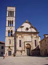
The Cathedral of Sv. Stjepan (St. Stephen) and the Bishop's Palace mark the eastern end of the Pjaca. This was the site of an earlier church and medieval Benedictine monastery, which became a Cathedral when the Bishopric of Hvar was moved from Stari Grad in the 13th century. The present Cathedral was built in stages during the 16th and 17th centuries, while the interior was not completed until the 18th century. It has a Renaissance-baroque style, and a façade with three-cornered gable and a Renaissance Bell Tower in Romanesque style from the 16th century. The sanctuary of the nave is the nave of the former Gothic church: the two pulpits, the stone polyptich with "The altar of the Apostles", and relieves "The Scourging of Christ" and the "Annunciation", from the workshop of Juraj Dalmatinac in the 15th century. There are eleven baroque altars, created by Venetian artists.[2]
On the northern side of the Pjaca are many renaissance buildings, such as the Paladini Palace, and the unfinished Hektorovic Palace (Gothic, 15th century).

The town Loza (Loggia) lies at the western end of the Pjaca, looking out on to the bay. Together with Leroj (Clock Tower), the Loggia is the only remains of the former Governor's Palace.[2] The Communal Loggia (loggia communis) was first mentioned as early as in the 13th century and referred to again in the Statute of Hvar in 1331.[2] The only remains of the Governor's Palace are two reliefs of the Venetian lion, a large well and a lintel from the Palace chapel dating from 1612. The new Loggia, one of the most beautiful Late Renaissance buildings in Dalmatia, was the work of the master Tripun Bokanić in the 16th century. Today, the interior of the loggia is decorated in a neo-Renaissance style and serves as a reception hall and exhibition room not only for the Hotel Palace, but also for the town of Hvar.
A small enclosed marina Mandrać lies at the west side of the Pjaca, and is mentioned for the first time in 1459.[3] In 1795 the Venetian District Governor Marco Dandalo finished the building of Mandrac by putting Baroque pyramids on the walls around it.[2] The stone paved quay, called Fabrika, is one of the oldest in Europe, dating from 1554.
On the cape to the south of the town lies the Franciscan Monastery with a church of Our Lady of Mercy, built in the late 15th century.[3] Hanibal Lucić's grave is under the main altar in the church. The cloister, with its monumental rounded arches with a well in the middle, dominates the whole of the Renaissance monastery. The bell tower, in Renaissance style, is the work of an artist from Korčula.
Ljetnikovac Hanibal Lucića (Hanibal Lucić's Summer Residence) lies in the fields outside the town walls, to the east. Built in 1530, it is a fine example of a Renaissance country house with enclosed garden and outbuilding. Currently a museum.[8]
Notable residents
- Hanibal Lucić (1485–1553) - author
- Mikša Pelegrinović (1500–1562) - author
- Petar Hektorović (1487–1572) - poet, author
- Vinko Pribojević (16th century) - historian, author
- Martin Benetović (1553–1607) - playwright, author, musician, painter
- Marin Gazarović (17th century) - poet, playwright, author
- Ivan Vučetić (1858–1925) - criminologist, pioneered the use of fingerprinting
- Grga Novak (1888–1978) - historian, archaeologist
- dr.Niko Duboković Nadalini (1911-1991),historian
- Dinko Fio (1924–2011) - composer, founder of Klapa Nostalgija
- Gabi Novak (born 1936) - singer
- Marin Carić (1947–2000) - theatre director
- Kuzma Kovačić (born 1952) - sculptor
- Slobodan Prosperov Novak (born 1951) - professor, historian
See also
- Hvar Rebellion
- Hvar (island)
- Brač
- Dalmatia
- Split-Dalmatia county
References
- ↑ 1.0 1.1 Census of Population, Households and Dwellings, 31 March 2001, Republic of Croatia: Central Bureau of Statistics, 2001, retrieved 14 July 2009
- ↑ 2.0 2.1 2.2 2.3 2.4 2.5 2.6 2.7 2.8 Novak, Grga (1960) [1924], Hvar Kroz Stoljeća (Hvar Through the Centuries), Historijski Arhiv - Hvar (Historical Archives of Hvar) (in Croatian) I (2nd ed.), Narodni Odbor Općine Hvar (National Council of Hvar Municipality)
- ↑ 3.0 3.1 3.2 3.3 3.4 3.5 3.6 Ring, Trudy; Salkin, Robert M.; La Boda, Sharon (1996) [1995], Robert M. Salkin; Sharon La Boda, eds., International Dictionary of Historical Places (Vol 3:Southern Europe) (2nd ed.), Taylor and Francis, pp. 331–334, lay summary
- ↑ 4.0 4.1 4.2 4.3 4.4 Tourist Board of City of Hvar, retrieved 14 July 2009
- ↑ Ferry Schedule, Jadrolinija Ferries, retrieved 21 July 2009
- ↑ S., J. (16 July 2000), Otvoren Tunel na Hvaru (Tunnel Open on Hvar) (in Croatian), Vjesnik Online (Online Gazette)
- ↑ "Monthly Climate Values". Croatian Meteorological and Hydrological Service. Retrieved 2014-08-22.
- ↑ 8.0 8.1 8.2 8.3 8.4 The Hvar Heritage Museum, retrieved 14 July 2009
- ↑ 9.0 9.1 Gaffney, Vincent; Stančič, Zoran; with preface by Kvamme, Kenneth (1996) [1991], GIS approaches to regional analysis: A case study of the island of Hvar, Znanstveni institut Filozofske fakultete Ljubljana
- ↑ Zaninović, Marin (December 2008), A little more on Hvar's Herakleia, Journal of Dalmatian Archaeology and History, No. 101, Hrcak, pp. 143–156, retrieved 14 July 2009
- ↑ Tim, Taylor; Fredotovic, Maja; Povh, Daria; Markandya, Anil, Sustainable Tourism and Economic Instruments: The Case of Hvar, Croatia, University of Bath, p. 18
External links
| Wikimedia Commons has media related to Hvar. |
| ||||||||||
| ||||||||||||
