Hurricane Erika (2003)
| Category 1 hurricane (SSHWS/NWS) | |
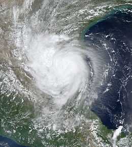
 Hurricane Erika at peak intensity over northeastern Mexico on August 16 | |
| Formed | August 14, 2003 |
|---|---|
| Dissipated | August 17, 2003 |
| Highest winds |
1-minute sustained: 75 mph (120 km/h) |
| Lowest pressure | 986 mbar (hPa); 29.12 inHg |
| Fatalities | 2 direct |
| Damage | $10,000 (2003 USD) |
| Areas affected | Florida, Mexico, Southern Texas |
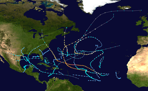
| Part of the 2003 Atlantic hurricane season | |
Hurricane Erika was a weak hurricane that struck extreme northeastern Mexico near the Texas-Tamaulipas border in mid-August of the 2003 Atlantic hurricane season. Erika was the eighth tropical cyclone, fifth tropical storm, and third hurricane of the season. At first, the National Hurricane Center (NHC) operationally did not designate it as a hurricane because initial data suggested winds of 70 mph (115 km/h) at Erika's peak intensity. It was not until later data was analyzed that the NHC revised it to Category 1 intensity in the Saffir-Simpson Hurricane Scale. The storm developed from a non-tropical area of low pressure that was tracked for five days before developing in the eastern Gulf of Mexico on August 14. Under the influence of a high pressure system, Erika moved quickly westward and strengthened under favorable conditions. It made landfall as a hurricane on northeastern Mexico on August 16 and rapidly dissipated inland.
While Erika's precursor disturbance was moving across Florida, it dropped heavy rainfall. In south Texas, Erika produced moderate winds of 50 to 60 mph (80 to 95 km/h) along with light rain, causing minor and isolated wind damage in the state. In northeastern Mexico, Erika produced moderate amounts of rainfall, resulting in mudslides and flooding. There, two people were killed when their vehicle was swept away by floodwaters.
Meteorological history

A weak surface area of low pressure detached from a frontal system on August 8 while 1,150 miles (1,850 km) to the east of Bermuda. It moved southwestward, and on August 9, it generated convection as it passed beneath a cold-core upper-level low. The surface low and the upper-level low turned westward as it revolved around a common center, and by August 11, the surface low developed into a trough while 440 miles (700 km) south of Bermuda. As the system rapidly continued westward, much of the convection remained near the center of the upper-level low, preventing development of a closed surface circulation. On August 13, while located near the northwestern Bahamas, a substantial increase in convection resulted in the upper-level low building downwards to the middle levels of the troposphere, coinciding with the development of an upper level anticyclone.[1]
A closed low-level circulation nearly developed on August 14 to the east of Key Largo, Florida, but it weakened due to the deep convection remaining to the north over the mid-level center. The mid-level storm continued westward and moved across Florida.[1] After crossing Florida, Hurricane Hunters indicated a poorly defined circulation, but with winds exceeding tropical storm strength, and the system was designated as Tropical Storm Erika late on August 14 while located 85 miles (135 km) west of Fort Myers.[2]

With well-established outflow and low levels of wind shear,[2] Erika strengthened as the circulation became better defined. A high pressure system persisted over the south-central United States, forcing the storm to move just south of due west at 25 mph (40 km/h). On August 15, convection organized into bands, and as its winds approached hurricane strength, an eye developed within the storm. Erika turned to the west-southwest on August 16, and attained hurricane status just prior to making landfall near Boca San Rafael, Tamaulipas in northeastern Mexico, or about 40 miles (70 km) south of the United States–Mexico border. The storm rapidly weakened over the mountainous Sierra Madre Oriental, and Erika dissipated early on August 17.[1] The mid-level circulation maintained integrity as it crossed Mexico, and led to the formation of a tropical disturbance after entering the Gulf of California on August 18. It turned to the northwest and weakened on August 20.[3]
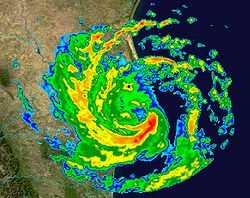
Operationally Erika was never upgraded to hurricane status. Based on a persistent eye feature on radar and Doppler weather radar-estimated surface winds of 75 mph (120 km/h), the National Hurricane Center posthumously upgraded Erika to a hurricane.[1]
Preparations

The threat of Erika's onslaught prompted the evacuation of 51 oil platforms and 3 oil rigs in the western Gulf of Mexico. The lack of production led to a loss of production of 8,708 barrels (1,384.5 m3) of oil per day and 173.14 million cubic feet (4,903,000 m3) of natural gas per day. On the day of its landfall, the lack of production led to 1,979 less barrels of oil for the day, or about 0.12% of the total daily production for the Gulf of Mexico, while the loss of 32 million cubic feet (910,000 m3) of gas for the day was equivalent to 0.23% of the total production.[4] However, due to its rapid motion, the passage of the storm resulted in minimal effects on operations.[5]
While the storm was located in the eastern Gulf of Mexico on August 15, the National Hurricane Center issued a Hurricane Watch and Tropical Storm Warning from Brownsville to Baffin Bay, Texas. The center also recommended a Hurricane Watch spanning from Soto la Marina, Tamaulipas to the international border. Late that same day, when strengthening was underway, a Hurricane Warning was either issued or recommended from La Pesca, Mexico to Baffin Bay, Texas, though the warnings for south Texas were dropped when a more southward motion occurred.[1] Just one month after Hurricane Claudette caused millions in damage in south Texas, the fast movement of Erika caught citizens by surprise as it was forecast to make landfall near Brownsville. Citizens and business owners boarded up for the storm.[6] About 10,000 were evacuated from northeastern Mexico due to the threat for flooding,[7] including 2,000 in Matamoros.[5]
Impact

The precursor disturbance was expected to bring heavy, yet needed rainfall to the Bahamas.[8] The precursor disturbance dropped heavy precipitation while moving across Florida, including in Indian River County,[9] and also produced 6–8 ft (1.8–2.4 m) waves with moderate wind gusts.[10]
Erika produced light rainfall across southern Texas, peaking at 3.83 inches (97 mm) in Sabinal,[11] though most locations reported less than two inches (50 mm) of precipitation. In addition, weather radar estimated isolated accumulations of 4 to 6 inches (100 to 150 mm) of precipitation in Kenedy and Brooks Counties. Sustained winds from Erika in south Texas peaked at 39 mph (62 km/h) in Brownsville, where a gust of 47 mph (75 km/h) was also recorded.[1] Strong waves were reported northwards to Corpus Christi.[12] The storm caused minor flooding and beach erosion along South Padre Island.[1] Strong wind gusts of up to 60 mph (95 km/h) caused isolated, minor wind damage in south Texas, including in South Padre Island, where the winds damaged the roof of a business. The winds also uprooted a large tree and caused limb damage to several small- to medium-sized trees in Brownsville. In Texas, damage totaled to $10,000 (2003 USD, $12.8 thousand 2015 USD).[13]
In Mexico, Hurricane Erika primarily affected the states of Tamaulipas and Nuevo León, but also had effects on Coahuila as well. Rainfall peaked at 6.71 inches (170.5 mm) in Magueyes in Tamaulipas.[14] Several other locations reported over 3 inches (76 mm),[1] including 4.02 inches (102 mm) in Cerro Prieto, which was the maximum amount in the state of Nuevo León,[14] and 3.42 inches (86.8 mm) in Monterrey,[1] where 30 people were injured.[7] Sustained winds peaked at 40 mph (65 km/h) in San Fernando, where a gust of 65 mph (105 km/h) was also reported.[1] The heavy rainfall resulted in severe flooding and mudslides, blocking several highways in northeastern Mexico.[14] In Matamoros, the storm damaged roofs and cars.[7] Moderate winds snapped tree branches and spread debris across roads, though locals considered the storm minor.[5] In the Nuevo León city of Montemorelos, two people died when they were swept away after they drove their truck across a partially flooded bridge.[1] Throughout Mexico, 20,000 people were left without power due to the storm.[7] The remnant circulation produced heavy amounts of precipitation in western Mexico and Baja California.[3]
See also
Tropical cyclones portal
References
- ↑ 1.0 1.1 1.2 1.3 1.4 1.5 1.6 1.7 1.8 1.9 1.10 Franklin (2003). "Hurricane Erika Tropical Cyclone Report". NHC. Retrieved 2006-09-24.
- ↑ 2.0 2.1 Avila (2003). "Tropical Storm Erika Discussion One". NHC. Retrieved 2006-09-24.
- ↑ 3.0 3.1 David Roth (2007). "Rainfall Data for Hurricane Erika". Hydrometeorological Prediction Center. Retrieved 2007-01-04.
- ↑ U.S. Department of the Interior (2003). "Tropical Storm Erika Evacuation and Production Statistics". Archived from the original on August 29, 2006. Retrieved 2006-09-24.
- ↑ 5.0 5.1 5.2 Deborah Tedford (2003). "Tropical Storm Erika Lashes Northern Mexico". Reuters. Retrieved 2006-10-15.
- ↑ Lynn Brezosky (2003). "Erika forecast to hit Texas". Associated Press.
- ↑ 7.0 7.1 7.2 7.3 Desde Dominicana (2003). "17 de agosto de 2003" (in Spanish). Retrieved 2006-09-24.
- ↑ Stormcarib.com (2003). "Unofficial Bahamas Reports". Retrieved 2006-09-25.
- ↑ Nathan B. Collum (2003). "2003 Hurricane Season Summary" (PDF). Florida Department of Emergency Services. Retrieved 2006-09-25.
- ↑ Lourdes Briz (2003). "Surfing News from the Space Coast". Florida Today. Archived from the original on July 23, 2004. Retrieved 2006-09-25.
- ↑ Roth, David M; Hydrometeorological Prediction Center (November 16, 2012). "Tropical Cyclone Rainfall Point Maxima". Tropical Cyclone Point Maxima. United States National Oceanic and Atmospheric Administration's National Weather Service. Retrieved December 7, 2012.
- ↑ Rob Marciano (2003). "Tropical Storm Erika Misses Texas". CNN. Retrieved 2006-09-25.
- ↑ National Climatic Data Center (2003). "Event Report for Cameron County". Retrieved 2006-09-25.
- ↑ 14.0 14.1 14.2 Servicio Meteorológico Nacional (2003). "Tormenta Tropical "Erika" del Océano Atlántico" (in Spanish). Archived from the original on July 21, 2006. Retrieved 2006-09-25.
External links
| Wikimedia Commons has media related to Hurricane Erika (2003). |
| |||||||||||||
