Hurricane Edith (1963)
| Category 2 hurricane (SSHWS/NWS) | |
 An infrared satellite image of Hurricane Edith | |
| Formed | September 23, 1963 |
|---|---|
| Dissipated | September 29, 1963 |
| Highest winds |
1-minute sustained: 100 mph (155 km/h) |
| Lowest pressure | 990 mbar (hPa); 29.23 inHg |
| Fatalities | 10 |
| Damage | $43 million (1963 USD) |
| Areas affected | Lesser Antilles, Trinidad and Tobago, Puerto Rico, Hispaniola, Turks and Caicos Islands, Bahamas |
| Part of the 1963 Atlantic hurricane season | |
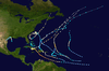
Hurricane Edith brought flood and wind damage to portions of the Greater and Lesser Antilles. The fifth named storm and fifth hurricane of the annual season, Edith developed from an Intertropical Convergence Zone (ITCZ) disturbance while located east of the Windward Islands on September 23, 1963. Initially a tropical depression, it strengthened into Tropical Storm Edith on September 24. Only six hours later, Edith reached hurricane status. After becoming a Category 2 hurricane, it fluctuated slightly in intensity, weakening to a Category 2 hurricane before striking Saint Lucia on September 25. The storm tracked west-northwestward across the Caribbean Sea, but re-curved north-northwestward on September 26. Edith made landfall near La Romana, Dominican Republic early on the following day as a minimal hurricane. Interaction with land and an extratropical cyclone caused Edith to weaken to a tropical storm on September 28 and to a tropical depression by the next day. The storm dissipated just east of the Bahamas on September 29.
In Martinique, strong winds, heavy rainfall, and rough seas were reported. Ten deaths were confirmed on the island. Strong winds on Saint Lucia ruined about half of the island's banana crop. Damage reached slightly less than $3.47 million (1963 USD). Overall, Edith caused 10 deaths and $43 million in damage.
Meteorological history

The origins of Edith were first observed on September 22 when a tanker east of the Lesser Antilles reported winds of 28 mph (45 km/h) in the Intertropical Convergence Zone.[1] The next day satellite imagery indicated that a surface circulation had developed, suggesting that a tropical depression had formed 400 miles (645 km) east of Barbados.[1] Later on September 23 the hurricane hunters confirmed the development of a depression, at which time the Weather Bureau initiated advisories on the system.[1] Another flight on September 24 indicated that the depression had strengthened into Tropical Storm Edith and then into a hurricane shortly after.[2]
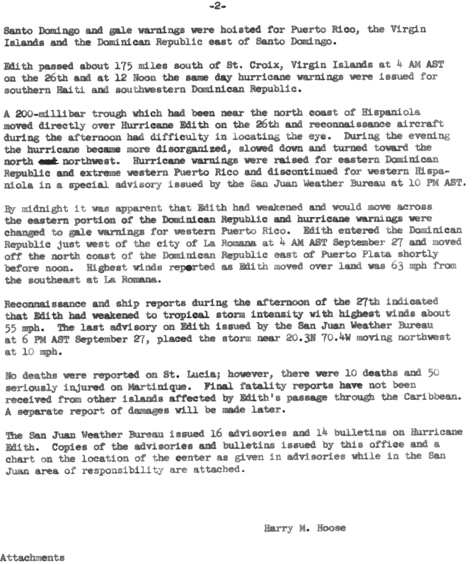
On September 25, the hurricane passed over the island of St. Lucia and subsequently moved into the Caribbean Sea where it strengthened slightly to its peak of 100 mph (160 km/h).[1] Early the next morning, Edith moved towards Hispaniola and made landfall slightly west of La Romana, Dominican Republic.[1] Edith weakened hours after landfall due to an extratropical cyclone located near South Florida. The wave moved to the east-northeast while strengthening into a low with a pressure of 1,005 millibars (29.7 inHg), 600 miles away from Edith.[3] This occurred as Edith was nearing eastern Hispaniola. During this time, a broad surface low was forming in the Gulf of Mexico.[3] The extratropical cyclone weakened the pressure gradient in the Bahamas region significantly and as a result the easterly flow north of Edith was disrupted.[3][4] This was the main reason for her weakening and eventual dissipation. The mountains of Hispaniola also contributed to Edith's demise and the flat pressure gradient north of Hispaniola prevented any redevelopment.[3] After landfall, Edith spent about eight hours on land and exited the northern coast of Hispaniola approximately at noon on September 26.[5] Shortly after, Edith dissipated and the final advisory was issued at 5 pm on September 28.[1]
Preparation
The warnings and advice given by the San Juan Weather Bureau were credited for limiting damage and loss of life on Martinique.[6] While Edith was 120 miles (193 kilometers) east of Barbados hurricane warnings were posted for both the Windward and Leeward Islands due to Edith's proximity. The warning area covered from Guadeloupe to St. Vincent, including Barbados. Gale warnings were also issued for areas north of Guadeloupe to St. Maarten. As Edith approached St. Lucia, a hurricane watch was issued for Puerto Rico and the Virgin Islands. After Edith entered the Caribbean, the watch was spread to Haiti and the Dominican Republic. Whole gale warnings were issued for the south coast of Hispaniola, west and east of Santo Domingo, Puerto Rico, the Virgin Islands. Edith passed south of Puerto Rico at 4am on September 26 and hurricane warnings were issued at noon for southern Haiti and southwestern Dominican Republic due to the impending threat.[5] Edith began to slow and began a more northerly movement, because of this, a hurricane warning was issued for the eastern portion of the Dominican Republic and western Puerto Rico, while, the warning for western Hispaniola was discontinued.[5] By midnight on September 27, the storm had weakened and it was clear that Edith would pass over the Dominican Republic.[1] As a result of this the hurricane warning for Puerto Rico was downgraded to a gale warning.[1] A total of 16 advisories and 14 bulletins were issued for Edith.[1]
Impact
Hurricane Edith was responsible for 10 deaths, 50 serious injuries, and $43 million in damage.[4] Edith passed just north of Barbados and delivering between 7–9 inches (180–230 mm) of rain to the island. Wind speeds were between 60 and 65 mph (97 and 105 km/h) in areas of bad weather in the northern section of the island.[4][7] Damage on the island totaled $145,000.[4] In Martinique Edith took 10 lives and left 50 people seriously injured.[4] Serious wind and flood damage was also reported along with 125 mph (201 km/h) winds and strong waves.[4][7] It was reported that there was material damage in Martinique, but the loss of life was low thanks to the advisories and warnings from the San Juan Weather Bureau. The Met office in Le Lamentin Airport experienced wind gusts up to 127 mph (200 km/h). Damage was estimated to be $40 million.[6] St. Lucia experienced wind gusts up to 90 mph (100 km/h).[4] These winds were accompanied by heavy, flooding rains and the island received wind and flood damage as the hurricane made landfall.[1] Also in St. Lucia, about half of the banana crop was damaged as wind speeds reached 90 mph (140 km/h).[4] The damage on the island totaled to $3,465,000,[4] but no deaths were reported.[1] Damage in the Dominican Republic was minor and winds between 50 and 60 mph (80 and 97 km/h) were recorded along with heavy rain.[4]

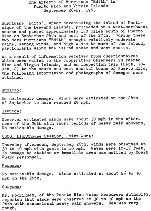
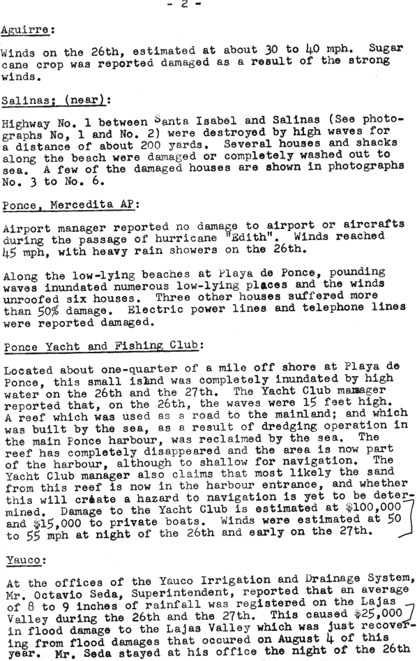
Hurricane Edith affected Puerto Rico for two days, September 16 and 17. During this time, Puerto Rico was subjected to moderate rains, strong winds and rough seas.[8] Near Salinas, Puerto Rico about 200 feet of Highway One was destroyed by high surf.[8] Several beach front properties were badly damaged.[9] At Ponce Beach, waves completely flooded low-lying area and strong winds blew roofs off some houses.[9] Damages to the Yacht club totaled $100,000 and damages to the boats totaled $15,000.[9] Mr Octavio Seda, the superintendent at the Yauco Irrigation and Drainage System, reported that 8 inches (200 mm) to 9 inches (230 mm) of rainfall fell in the Lajas valley during the passage of Hurricane Edith and [9] damage from this rainfall totaled to $25,000.[9] The superintendent reported that winds reached 50 mph (80 km/h) and[10] at Ensenada waves were reported to be as high as 15 feet and winds were estimated as 50 mph (80 km/h), because of these conditions many trees were uprooted.[10]
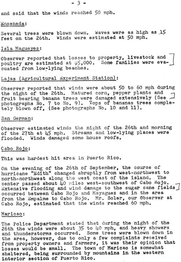
At the Agricultural Experiment Station in Lajas crops were reported to be heavily damaged by high winds.[10] During the evening of September 26 Cabo Rojo bore the brunt of the storm with the center passing within 50 mi (80 km) which produced 60 mph (97 km/h) winds, major flooding and extensive wind damage and winds were estimated to be 60 mph (97 km/h).[10] The police department in Maricao observed the winds to be between 35 and 40 mph (56 and 64 km/h) on September 16 and heavy storms were also reported in the area [10] and a few trees were blown down, but not a lot of damage was reported there.[10]
References
- ↑ 1.0 1.1 1.2 1.3 1.4 1.5 1.6 1.7 1.8 1.9 1.10 Hurricane Edith, September 23-28, 1963, preliminary report with advisories and bulletins issued. (PDF) (Report). United States Weather Bureau. December 2, 1963. Retrieved August 21, 2013.
- ↑ "Hurricane Edith report". San Juan Weather Bureau. Retrieved 5 July 2010.
- ↑ 3.0 3.1 3.2 3.3 "National Hurricane Center Edith notes". National Hurricane Center. Retrieved 11 July 2010.
- ↑ 4.0 4.1 4.2 4.3 4.4 4.5 4.6 4.7 4.8 4.9 The Hurricane Season Of 1963 (PDF). Atlantic Oceanographic and Meteorological Laboratory (Report) (National Oceanic and Atmospheric Administration). March 1964. Retrieved August 21, 2013.
- ↑ 5.0 5.1 5.2 "Report B". San Juan Weather Bureau. Retrieved 5 July 2010.
- ↑ 6.0 6.1 M. Perrusset (October 2, 1963). Martinique (Report). United States Weather Bureau. Retrieved August 21, 2013.
- ↑ 7.0 7.1 Terry Alley (September 5, 1999). "Always a near miss for Barbados". Caribbean Disaster Emergency Management Agency. Sunday Sun. Archived from the original on November 15, 2010. Retrieved July 5, 2010.
- ↑ 8.0 8.1 Hurricane "Edith" Report. United States Weather Bureau (Report) (National Hurricane Center). Retrieved August 21, 2013.
- ↑ 9.0 9.1 9.2 9.3 9.4 Hurricane "Edith" Report. United States Weather Bureau (Report) (National Hurricane Center). Retrieved August 21, 2013.
- ↑ 10.0 10.1 10.2 10.3 10.4 10.5 Hurricane "Edith" Report. United States Weather Bureau (Report) (National Hurricane Center). Retrieved August 21, 2013.
External links
| |||||||||||||