Hurricane Easy (1951)
| Category 5 major hurricane (SSHWS/NWS) | |
| Formed | September 2, 1951 |
|---|---|
| Dissipated | September 13, 1951 |
| Highest winds |
1-minute sustained: 160 mph (260 km/h) |
| Lowest pressure |
≤ 957 mbar (hPa); 28.26 inHg (estimated) |
| Fatalities | None direct |
| Damage | None |
| Areas affected | Bermuda, North Atlantic Ocean |
| Part of the 1951 Atlantic hurricane season | |
Hurricane Easy was the strongest tropical cyclone of the 1951 Atlantic hurricane season. It was a Cape Verde-type hurricane that recurved away from land masses. The fifth tropical cyclone, fourth hurricane, and fourth major hurricane of the season, Easy formed 1,000 miles (1,610 km) west of Cape Verde on September 2. It steadily strengthened to a hurricane on September 3, moving west-northwest across the Atlantic Ocean. On September 5, it attained Category 3 status with 115 mph (185 km/h) sustained winds, and it intensified to its maximum intensity of 160 mph (260 km/h) on September 7. The cyclone turned northward, completing its recurvature on September 8. It slowly weakened, passing within 120 miles (190 km) of Bermuda on September 9. It continued northeast, and the tropical system became extratropical on September 12. The hurricane caused no deaths, though it damaged several ships' superstructures.
Meteorological history
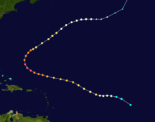
On September 2, a minimal tropical storm formed over the eastern Atlantic Ocean. Operationally, it was first detected by the steamship Barn, which reported the presence of a circulation.[1] Initially, the tropical cyclone moved generally westward, and it strengthened to a hurricane on September 3.[2] The progress of the system was monitored by aircraft over the next few days.[1] On September 4, the storm continued to strengthen, and its maximum sustained winds increased to Category 2 status.[2] On September 5, it strengthened to a major hurricane, and it slowly deepened over the next 48 hours.[2] Its forward motion increased, and the hurricane turned westward 650 miles (1,045 km) northeast of Anguilla.[2] On September 6, the cyclone's winds increased to 140 mph (225 km/h), and its minimum central pressure of 957 mbar (28.26 inHg) was recorded on the same day.[1] Later, it reached its estimated peak intensity of 160 mph (260 km/h) on September 7.[2] At the time, the hurricane's extreme intensity prevented thorough measurements and penetration by aircraft, and the cyclone's strongest winds were recorded south of the eye.[1] The strength of the winds forced the plane to turn around, so the storm's maximum winds were believed to have been stronger; unofficial estimates ranged between the values of 160–200 mph.[1]
The cyclone began its recurvature,[1] maintaining Category 5 winds for 18 hours.[2] On September 8, it weakened to a Category 4 hurricane, and its movement turned northeast. The hurricane encountered wind shear from Hurricane Fox, and its winds decreased.[3] The recurvature spared land masses from a strike by the hurricane.[1] On September 9, its winds dropped below major hurricane status, and the cyclone passed southeast of Bermuda.[2][3] On September 10, it weakened to a Category 1 hurricane, and it turned to the east on September 11. On September 12, it transitioned to an extratropical storm, though it still produced winds of hurricane force.[2] Its strong winds weakened on September 13, and its remnants turned northward. It dissipated on the same day.[2]
In the early 1950s, code names were utilized for Atlantic tropical cyclones until female lists were compiled in 1953.[4] Hurricane Easy was one of only two Category 5 Atlantic hurricanes to avoid landfall—the other was Cleo of 1958.[2]
Preparations and impact
On September 9, the hurricane was expected to pass near Bermuda and produce hurricane force winds over the island.[5] The hurricane was expected to turn east-northeast because of interactions with Hurricane Fox.[5] The Weather Bureau advised the island to take precautionary measures in advance of the storm;[5] tourists and residents "worked feverishly" to complete preparations, and the United States Air Force issued "a formal warning at noon."[6] Numerous hotels and homes were shuttered. Heavy traffic snarled evacuations, and 100 tourists were stranded on the island without "roundtrip reservations." Air Force aircraft returned to the United States, and personnel secured various facilities at the island's base.[6] The cyclone turned sharply away from the island, preventing heavy damages. Peak sustained winds were estimated between 25–50 mph (40–80 km/h).[3] Telephone lines remained intact, and some banana trees were blown down by the winds.[3]
See also
References
- ↑ 1.0 1.1 1.2 1.3 1.4 1.5 1.6 Norton, Grady (1952). "Hurricanes of 1951" (PDF). U.S. Weather Bureau. Retrieved 2008-02-08.
- ↑ 2.0 2.1 2.2 2.3 2.4 2.5 2.6 2.7 2.8 2.9 National Hurricane Center; Hurricane Research Division (March 2, 2015). "Atlantic hurricane best track (HURDAT version 2)". United States National Oceanic and Atmospheric Administration. Retrieved April 25, 2015.
- ↑ 3.0 3.1 3.2 3.3 The Associated Press (1951). "Clash of Hurricanes Spares Bermuda Isle From Heavy Damage". San Antonio Express.
- ↑ National Hurricane Center. "Worldwide Tropical Cyclone Names". NOAA. Retrieved 2008-02-09.
- ↑ 5.0 5.1 5.2 International News Service (1951). "Bermuda Set For Hurricane". The Galveston Daily News.
- ↑ 6.0 6.1 United Press (1951). "Big Blow Nears Bermuda". Waterloo Sunday Courier.
| ||||||||||||||||||||||||||||||||||||||
| |||||||||||||
