Huriel
| Huriel | ||
|---|---|---|
|
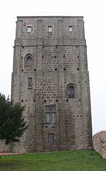
Roman keep | ||
| ||
 Huriel | ||
|
Location within Auvergne region  Huriel | ||
| Coordinates: 46°22′26″N 2°28′39″E / 46.3739°N 2.4775°ECoordinates: 46°22′26″N 2°28′39″E / 46.3739°N 2.4775°E | ||
| Country | France | |
| Region | Auvergne | |
| Department | Allier | |
| Arrondissement | Montluçon | |
| Canton | Huriel | |
| Intercommunality | Pays d'Huriel | |
| Government | ||
| • Mayor (2008–2014) | Gérard Bourricat | |
| Area1 | 34.92 km2 (13.48 sq mi) | |
| Population (2008)2 | 2,471 | |
| • Density | 71/km2 (180/sq mi) | |
| INSEE/Postal code | 03128 / 03380 | |
| Elevation |
210–418 m (689–1,371 ft) (avg. 332 m or 1,089 ft) | |
|
1 French Land Register data, which excludes lakes, ponds, glaciers > 1 km² (0.386 sq mi or 247 acres) and river estuaries. 2 Population without double counting: residents of multiple communes (e.g., students and military personnel) only counted once. | ||
Huriel is a commune in the Allier department in central France.
Population
| Historical population | ||
|---|---|---|
| Year | Pop. | ±% |
| 1962 | 2,220 | — |
| 1968 | 2,237 | +0.8% |
| 1975 | 2,147 | −4.0% |
| 1982 | 2,347 | +9.3% |
| 1990 | 2,606 | +11.0% |
| 1999 | 2,377 | −8.8% |
| 2008 | 2,471 | +4.0% |
See also
References
| Wikimedia Commons has media related to Huriel. |