Hunza Valley
Coordinates: 36°19′N 74°39′E / 36.317°N 74.650°E


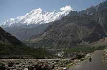
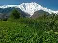
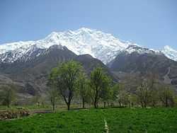
The Hunza (Burushaski and Urdu: ہنزہ) is a mountainous valley in the Gilgit–Baltistan region of Pakistan. The Hunza is situated north/west of the Hunza River, at an elevation of around 2,500 metres (8,200 ft). The territory of Hunza is about 7,900 square kilometres (3,100 sq mi). Aliabad is the main town while Baltit is a popular tourist destination because of the spectacular scenery of the surrounding mountains like Ultar Sar, Rakaposhi, Bojahagur Duanasir II, Ghenta Peak, Hunza Peak, Passu Peak, Diran Peak and Bublimotin (Ladyfinger Peak), all 6,000 metres (19,685 ft) or higher.
History
Hunza was formerly a princely state bordering Uyghurstan to the northeast and Pamir to the northwest, which survived until 1974, when it was finally dissolved by Zulfikar Ali Bhutto. The state bordered the Gilgit Agency to the south and the former princely state of Nagar to the east. The state capital was the town of Baltit (also known as Karimabad); another old settlement is Ganish Village. Hunza was an independent principality for more than 900 years. The British gained control of Hunza and the neighbouring valley of Nagar between 1889 and 1892 through a military conquest. The then Mir/Thum (Ruler) Mir Safdar Ali Khan of Hunza fled to Kashghar in China and sought what would now be called political asylum.

First Muslim Mir/Thum
| “ | The ruling family of Hunza is called Ayeshe (heavenly). The two states of Hunza and Nagar were formerly one, ruled by a branch of the Shahreis, the ruling family of Gilgit, whose seat of government was Nager. First muslim came to Hunza-Nagar Valley some 1000years (At the time of Imam Islām Shāh 30th Imam Ismaili Muslims). After the introduction of Islam to Gilgit, married a daughter of Trakhan of Gilgit, who bore him twin sons, named Moghlot and Girkis. From the former the present ruling family of Nager is descended. The twins are said to have shown hostility to one another from birth. Thereupon their father, unable to settle the question of succession, divided his state between them, giving to Girkis the north/west, and to Moghlot the south/east bank of the river.[2] | ” |
Mir/Thum
The traditional name for the ruler or Prince in Hunza was Thum (also Thom or Tham), which is also a respectful greeting used by the people of both Hunza and Nager who belong to the clan of Boorish. The Shin use the term Yeshkun for the Boorish.
| “ | Both Thums are also addressed as Soori, a title of respect. This appears to be the same [in meaning] as Sri, an commonly prefixed to the names of Hindu princes in India, to denote their honour and prosperity. The Thum's wives are styled ghenish which is almost identical with the original Sanskrit word for mother, and their sons are called gushpoor.[3] | ” |
2010 landslide
In 2010, a landslide blocked the river and created Attabad Lake, which threatened 15,000 people in the valley below and has effectively blocked 27 km of the Karakoram Highway.[4]
Capital of Hunza
The first seat of power of the formerly Hunza State was Altit. Later it shifted to Baltit (modern-day Karimabad). Until the fall of princely state in 1974, Baltit served as political center of Hunza and hence its capital. Today, Baltit is one of the major tourist destinations in Hunza. The center of activities has however somewhat shifted to Aliabad, which is a commercial hub in the region and has most of the governmental infrastructure.
Geography

The Hunza is situated at an elevation of about 900 metres (3,000 ft). For many centuries, Hunza has provided the quickest access to Swat and Gandhara for a person travelling on foot. The route was impassable for pack animals; only human porters could get through, and then only with permission from the locals. Hunza was easily defended as the paths were often less than 0.5 metres (20 in) wide. The high mountain paths often crossed bare cliff faces on logs wedged into cracks in the cliff, with stones balanced on top. They were also constantly exposed to regular damage from weather and falling rocks. These were the much feared "hanging passageways" of the early travel accounts that terrified several famous Chinese Buddhist monks such as Xuanzang.
Hunza is divided into 3 Geographic Sub-Divisions:
Gojal Valley
Upper Hunza comprises the Gojal tehsil of Hunza–Nagar District. The main towns, villages and valleys are:
Lower Hunza
Lower Hunza comprises the parts of Aliabad tehsil of Hunza–Nagar District. The main towns, villages and valleys are:
- Murtazaabad
- Nasirabad
- Hussainabad
- Khizerabad
- Khanaabad
Khanabad is a beautiful and small hamlet in the mountains of Lower Hunza between Mayon and Nasir Abad on the Karakoram Highway in Pakistan. In 1902, eight families from Nasirabad came to the place (the old name was Jhok Das) and built water channel with the help of stones (without machines) through the mountains. Then Mir of Hunza sent 04 families from central Hunza also and they were also settled there. Now, after 111 years, the population of the village is around 1850 and house holds are around 280.
Central Hunza
Central Hunza comprises the parts of Aliabad tehsil of Hunza–Nagar District. The main towns, villages and valleys are:
- Murtazaabad: Murtazaabad is the first village of central Hunza, consisting of approximately 400 houses and a population of about 3000-4000. Murtazaabad is famous for fresh fruits, especially cherries. Gardens of Murtazaabad Ghuttoom (Thamobushie) and Farmanabad are spectacular. Furthermore there are five hot springs in Murtazaabad, namely Samate bool, Gurowel bool, Tulla Bull, Kutto Bull, and Khatkhan Bool. People of Murtazaazbad use these hot springs for laundry and bathing only, although these hot springs have enough intensity to cook beef within minutes. Sulfur rocks are found in Murtazaabad.
Aliabad
Climate

The temperature in May reaches a maximum of 27 °C (81 °F) and a minimum of 14 °C (57 °F); the October maximum is 10 °C (50 °F) and the minimum −10 °C (14 °F). Hunza's tourist season is generally from May to October, because in winter the Karakoram Highway is often blocked by the snow.
Transport
Today, the famous Karakoram Highway crosses Hunza, connecting Pakistan to China via the Khunjerab Pass, although blocked by the Attabad Lake north of Hunza. Travelling up the valley from the south, Hunza is to the left, and the former state of Nagar to the right of the Hunza River. Regular bus and van services operate between Gilgit and Central Hunza (Ganish Village, Aliabad and Karimabad) and also between Gilgit and Sost Gojal. PTDC Office at Gilgit, Sost and Islamabad arranges tours and transport for visitors.NATCO (Northern Area's Transport Co) runs a daily bus from Rawalpindi to Hunza.
Spectacular scenery
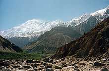
Several high peaks rise above 6,000 metres (20,000 ft) the Hunza valley. The valley provides spectacular views of some of the most beautiful and magnificent mountains of the world, including Rakaposhi 7,788 metres (25,551 ft), Ultar Sar 7,388 metres (24,239 ft), Bojahagur Duanasir II 7,329 metres (24,045 ft), Ghenta Sar 7,090 metres (23,261 ft), Hunza Peak 6,270 metres (20,571 ft), Darmyani Peak 6,090 metres (19,980 ft), and Bublimating (Ladyfinger Peak) 6,000 metres (19,685 ft). A watch tower is located in heart of Ganish Village, Baltit Fort stands on top of Karimabad whereas Altit Fort lies somewhat lower down the valley on another outcrop.
The valley is popularly believed to be the inspiration for the mythical valley of Shangri-la in James Hilton's 1933 novel Lost Horizon.
Duikar Valley
Duikar is a charming hamlet above the village of Altit. One of the main attractions of Duikar is the viewpoint (2900 m), a 5 minute climb up behind the Eagle’s Nest Hotel. This gives you one of the best views during sunrise and sunset, in particular at full-moon. From Eagle’s Nest Hotel it is a 1½ hours climb up to Hosht (3600 m). From there, there are great views of the Ultar Mountains and the Hopper glacier.
People of Hunza

The local languages spoken include Burushaski, Wakhi and Shina, although most people understand and speak Urdu as well. The literacy rate of the Hunza valley is believed to be more than 95%.[5] Hunza has been described as a "role model" for Pakistan in terms of its high literacy rate and school enrollment figures. Virtually every child is educated up to at least high school level.[5]
Most of the inhabitants of Hunza are Ismaili Shia Muslims, followers of His Highness Prince Karim Aga Khan IV, while in Ganish more than 65% are Shia Muslims.
The Hunza region is principally home to people of four ethnicities:
- The Lower Hunza area - from Khizerabad to Nasirabad is mainly inhabited by the Shinaki people who are Shina speakers.
- The Central Hunza area - from Murtazaabad to Attabad is mainly inhabited by Burushaski speakers, however, there is a centuries old locally inhabiting community as well that is known as the 'Domaki' which lives in a village lying in the immediate vicinity of 'Baltit' called 'Mominabad'.
- The Upper Hunza area, known as Gojal - from Shiskat to Khunjerab is mainly populated by Wakhi speakers and burusho speakers.
New district
Hunza–Nagar became a new district in Gilgit–Baltistan starting July, 2009. An additional Gilgit Baltistan Legislative Assembly (GBLA) seat for Hunza has been proposed.[6]
Altit Fort: A beautiful view of Hunza River
-
Nasirabad Valley Hunza - Rakaposhi View
-
Nasirabad Valley Hunza
-

Attabad Lake caused by a landslide in the valley on January 4, 2010.
-

The lake on 3 August 2011.
-

Closeup of the 2010 landslide
-

Women cross the Hunza River near Passu
-

Hunza Valley
-

Karimabad Hunza
-

passu gojal hunza
See also
|
| Wikimedia Commons has media related to Hunza. |
References
- ↑ EO
- ↑ Tribes of the Hindoo Koosh by John Bidulph page 26
- ↑ Tribes of the Hindoo Koosh by John Bidulph Sang e meel publication page 30
- ↑ http://www.dawn.com/wps/wcm/connect/dawn-content-library/dawn/news/sci-tech/03-rising-water-threatens-villages-in-hunza-ss-03
- ↑ 5.0 5.1 Siddiqui, Shahid. "Hunza disaster and schools". Dawn (newspaper). Retrieved 6 July 2012.
- ↑ HunzaTimes, June 24, 2009.
- Kreutzmann, Hermann, Karakoram in Transition: Culture, Development , and Ecology in the Hunza Valley, Oxford University Press, 2006. ISBN 978-0-19-547210-3
- Leitner, G. W. (1893): Dardistan in 1866, 1886 and 1893: Being An Account of the History, Religions, Customs, Legends, Fables and Songs of Gilgit, Chilas, Kandia (Gabrial) Yasin, Chitral, Hunza, Nagyr and other parts of the Hindukush, as also a supplement to the second edition of The Hunza and Nagyr Handbook. And An Epitome of Part III of the author’s “The Languages and Races of Dardistan.” First Reprint 1978. Manjusri Publishing House, New Delhi.
- Lorimer, Lt. Col. D.L.R. Folk Tales of Hunza. 1st edition 1935, Oslo. Three volumes. Vol. II, republished by the Institute of Folk Heritage, Islamabad. 1981.
- Sidkey, M. H. "Shamans and Mountain Spirits in Hunza." Asian Folklore Studies, Vol. 53, No. 1 (1994), pp. 67–96.
- History of Ancient Era Hunza State By Haji Qudratullah Beg English Translation By Lt Col (Rtd) Saadullah Beg, TI(M)
- Wrench, Dr Guy T (1938), The Wheel of Health: A Study of the Hunza People and the Keys to Health, 2009 reprint, Review Press, ISBN 978-0-9802976-6-9, retrieved 12 August 2010