Hrazdan
| Hrazdan Հրազդան | |
|---|---|
|
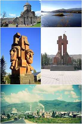
Hrazdan landmarks
Makravank Monastery • Hrazdan reservoir Artsakh War memorial • World War II memorial Hrazdan skyline | |
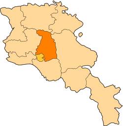
 Hrazdan Հրազդան Location of Hrazdan in Armenia | |
| Coordinates: 40°30′0″N 44°46′0″E / 40.50000°N 44.76667°ECoordinates: 40°30′0″N 44°46′0″E / 40.50000°N 44.76667°E | |
| Country Marz |
Kotayk |
| Founded | 1959 |
| Government | |
| • Mayor | Aram Danielyan |
| Area | |
| • Total | 22 km2 (8 sq mi) |
| Elevation | 1,675 m (5,495 ft) |
| Population (2011 est.) | |
| • Total | 53,400 |
| • Density | 2,400/km2 (6,300/sq mi) |
| Time zone | GMT+4 (UTC+4) |
| Postal code | 2301-2309 |
| Area code(s) | (+374) 223 |
| Website | www.hrazdan.am |
| Sources: Population [1] | |
Hrazdan (Armenian: Հրազդան) is the capital and largest city of the Kotayk Province of Armenia located 45 kilometres (28 miles) northeast of the capital Yerevan. The name Hrazdan is derived from the Middle-Persian name Frazdan. Farzdan is connected to the Zoroastrian mythology. With an estimated population of 53,400 (2011 official estimate), it is the fifth-largest city in Armenia by terms of population. It has lost a significant number of inhabitants since the 1989 census reported 59,000 people.
During the Soviet period, Hrazdan was one of the highly industrialized towns of the Armenian SSR.
History
Hrazdan is among the towns that have been founded and developed during the Soviet rule. The former village of Akhta (or Nerkin Akhta) -covering the southern parts of present-day Hrazdan- was the centre of the Hrazdan region (formerly known as Akhta region) between 1930-59. In 1959, Akhta village was granted the status of an urban-type settlement and renamed Hrazdan. The first development plan of Hrazdan was introduces in 1961-63 by architects M. Grigoryan and E. Altunyan. Upon the 12 January 1963 decision of the Supreme Soviet of the Armenian SSR on the territorial changes in the state, the villages of Atarbekyan, Jrarat, Kakavadzor and Makravan have been merged within the town of Hrazdan.[2] In fact, the town of Hrazdan was formed through the merger of a group of separate villages and settlements. Thus, after becoming a town of regional dependence, Hrazdan had witnessed a major development. The inhabitants of the town were originally from the regions of Sasun, Kars and Mush of Western Armenia, and the regions of Maku, Salmast and Khoy of present-day Iran, who arrived in Soviet Armenia between 1926-29. During the repatriation process, citizens from other regions of Armenia and Armenians from Diaspora were resettled in Hrazdan.
During the Soviet period, the population of the town reached up to 61,000. The 2nd development plan of the town was introduced in 1978-80, where it was envisaged to accommodate 120,000 inhabitants by the year 2010. However, the plan was eventually abandoned with the fall of the Soviet rule.
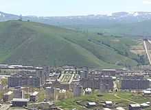
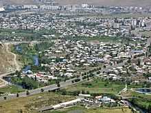
Present-day Hrazdan could be divided into 3 parts:
- Northern, including Jrarat district and the Hrazdan Power Plant.
- Central, including the Atarbekyan, Kentron and Makravan districts.
- Southern, including the Spandaryan and Aghbyurak districts along with the Hrazdan reservoir.
In December 1995, Hrazdan became the centre of the newly formed Kotayk province.
Geography and Climate

The town of Hrazdan is located in the northeastern part of Armenia, within the Kotayk Province. It is bordered by the Pambak mountains range from the north and the Tsaghkunyats mountain range from the southwest. The borders of the town are extended towards the east, crossing the Geghama mountains reaching up to the top of Mount Gutanasar. While passing through the town, Hrazdan River receives its tributaries; Marmarik and Aghveran rivers.
Hrazdan town has an average elevation 1675 meters above sea level. The average temperature is 4,8 °C (-9°C in January to 16,8°C in August).[3] The annual precipitation is between 715 and 730 mm.
| Climate data for Hrazdan | |||||||||||||
|---|---|---|---|---|---|---|---|---|---|---|---|---|---|
| Month | Jan | Feb | Mar | Apr | May | Jun | Jul | Aug | Sep | Oct | Nov | Dec | Year |
| Average high °F (°C) | 31.3 (−0.4) |
32.4 (0.2) |
39.6 (4.2) |
50.5 (10.3) |
59.5 (15.3) |
67.8 (19.9) |
74.1 (23.4) |
79.5 (26.4) |
68.9 (20.5) |
58.8 (14.9) |
45.9 (7.7) |
35.4 (1.9) |
53.64 (12.03) |
| Average low °F (°C) | 14.2 (−9.9) |
15.4 (−9.2) |
22.1 (−5.5) |
30.6 (−0.8) |
38.3 (3.5) |
44.4 (6.9) |
49.8 (9.9) |
50.2 (10.1) |
43.2 (6.2) |
36.0 (2.2) |
27.9 (−2.3) |
19.9 (−6.7) |
32.67 (0.37) |
| Average precipitation inches (mm) | 0.75 (19) |
0.91 (23.1) |
1.38 (35.1) |
2.17 (55.1) |
3.50 (88.9) |
2.91 (73.9) |
1.81 (46) |
1.51 (38.4) |
1.18 (30) |
1.61 (40.9) |
1.26 (32) |
0.75 (19) |
19.74 (501.4) |
Industry

Hrazdan is one of the most industrialized towns in the Republic of Armenia. The town is home to many large plants including:
- Hrazdan hydro power plant: built between 1954 and 1959 in the Aghbyurak district of Hrazdan. It has a water reservoir with an area of 1.7 km² and a capacity of 5,6 million m³.
- Hrazdan thermal power plant (HrazTES OJSC): one of the largest thermal power plants in the Caucasus, was built between 1963 and 1974 in the northwestern part of Hrazdan. It is operating since 1966. The power of the plant is 1110 megawatt.
- MIKA Cement factory of Hrazdan: founded in 1970 as Hrazdan Cement factory. It was privatized in 2001 to MIKA Limited. The plant is one of the largest enterprises in the Caucasus with a production capacity of 1.2 million tons of cement a year.
- Other minor industries in Hrazdan include carpet manufacturing, production of electrical equipment, building materials, dairy products and cattle-breeding.
Education and culture

Hrazdan is home to the Humanitarian University of Hrazdan. Owned by the private sector, the university has 3 faculties: law, pedagogy and economics. As of 2009, 13 public education schools, 13 nursery schools, 1 school for special needs and several musical and sport academies are operating in Hrazdan.
The Hrazdan Dramatic Theatre was founded in 1953. The Hrazdan branch of the National Gallery of Armenia and the Geological Museum of Hrazdan are also among the prominent cultural institutions in the town. The History Museum in Hrazdan founded by Armen Aivazyan, features more than 4000 historical remnants and valuable pieces.
Many religious structures in the town are among the favoorite destinations of the visitors:
- Aghbyurak Church of the 10th century.
- Surp Stepanos (Saint Stephen) Monastic Complex of the 10th century.
- Makravank Monastery, consists of 2 churches: Surp Amenaprkich (the Holy Saviour) of the 10th century and Surp Astvatsatsin (the Holy Motehr of God) of the 13th century.
- Surp Karapet Church of Jrarat, built in 1831.
- Surp Khach (Holy Cross) Church of Kojor, built in 1861.
- Surp Mariam Astvatsatsin (Holy Mother of God) Church of Vanatur, built in 1883.
Media
Hrazdan TV is a private TV company in Hrazdan, founded by the family of Harutyunyan.[4] The family also publishes a private newspaper and runs a radio company named known as Hrazdan Radio. The number of the Hrazdan TV viewers is around 220,000. The TV is broadcasting its programmes since 1 September 1991, covering the Kotayk Province and some parts of the Gegharkunik Province.
References
- ↑ Armstats:Population Archived 11 January 2011 at WebCite
- ↑ "Hrazdan city official website: Historical overview". Archived from the original on 2011-01-11.
- ↑ http://ohranatruda.ru/ot_biblio/normativ/data_normativ/1/1895/index.php#i1842743 (Russian)
- ↑ "About Company". Hrazdan TV official website.
- Hrazdan at GEOnet Names Server
- Report of the results of the 2001 Armenian Census, National Statistical Service of the Republic of Armenia