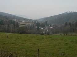
Hraběšice
| Hraběšice | |
|---|---|
| Municipality | |
 | |
 Hraběšice | |
| Coordinates: 49°58′14″N 17°4′26″E / 49.97056°N 17.07389°ECoordinates: 49°58′14″N 17°4′26″E / 49.97056°N 17.07389°E | |
| Country |
|
| Region | Olomouc |
| District | Šumperk |
| Area | |
| • Total | 8.22 km2 (3.17 sq mi) |
| Elevation | 530 m (1,740 ft) |
| Population (2006) | |
| • Total | 121 |
| • Density | 15/km2 (38/sq mi) |
| Postal code | 788 15 |
| Website | http://hrabesice.wz.cz/ |
Hraběšice is a village and municipality (obec) in Šumperk District in the Olomouc Region of the Czech Republic.
The municipality covers an area of 8.22 square kilometres (3.17 sq mi), and has a population of 121 (as at 3 July 2006).
Hraběšice lies approximately 8 kilometres (5 mi) east of Šumperk, 44 km (27 mi) north of Olomouc, and 191 km (119 mi) east of Prague.
References
| Wikimedia Commons has media related to Hraběšice. |