Hovgaard Island
 Hovgaard Island | |
 Antarctic Peninsula | |
| Geography | |
|---|---|
| Location | Antarctica |
| Coordinates | 65°7′S 64°4′W / 65.117°S 64.067°WCoordinates: 65°7′S 64°4′W / 65.117°S 64.067°W |
| Archipelago | Wilhelm Archipelago |
| Length | 5 km (3 mi) |
| Country | |
|
None | |
| Demographics | |
| Population | 0 |
| Additional information | |
| Administered under the Antarctic Treaty System | |
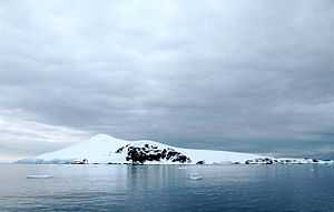
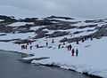
Hovgaard Island is an island 5 km (3 mi) long, lying off the northwest coast of Kiev Peninsula, 2.4 km (1.5 mi) southwest of Booth Island in the Wilhelm Archipelago, Antarctica.
It was discovered and named "Krogmann-Insel" (Krogmann Island) by the German 1873–74 expedition under Eduard Dallmann, but the name Hovgaard, applied by the Belgian Antarctic Expedition, 1897–99, under Gerlache, has overtaken the original name in usage. The name Krogmann Point has been given to the western extremity of Hovgaard Island.[1]
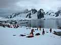
Hovgaard Island is a popular location for camping in Antarctica among expedition groups due to the presence of a relatively flat campsite along Penola Strait. Campers dig "snow graves" to sleep in. The holes offer protection from the wind. [2]
See also
- Composite Antarctic Gazetteer
- List of Antarctic islands south of 60° S
References
-
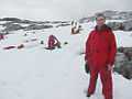
Campers on Hovgaard Island
-
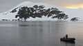
Hovgaard Island, Antarctica
-
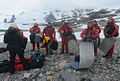
Campers on Hovgaard Island
-
Campers on Hovgaard Island
-
Campers on Hovgaard Island
![]() This article incorporates public domain material from the United States Geological Survey document "Hovgaard Island" (content from the Geographic Names Information System).
This article incorporates public domain material from the United States Geological Survey document "Hovgaard Island" (content from the Geographic Names Information System).