Hovea, Western Australia
| Hovea Perth, Western Australia | |||||||||||||
|---|---|---|---|---|---|---|---|---|---|---|---|---|---|
|
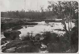
Hovea falls, Western Australia, ca. 1926 | |||||||||||||
 Hovea | |||||||||||||
| Coordinates | 31°52′26″S 116°06′25″E / 31.874°S 116.107°ECoordinates: 31°52′26″S 116°06′25″E / 31.874°S 116.107°E | ||||||||||||
| Population | 642 (2006 census)[1] | ||||||||||||
| Postcode(s) | 6071 | ||||||||||||
| LGA(s) | Shire of Mundaring | ||||||||||||
| State electorate(s) | Swan Hills | ||||||||||||
| Federal Division(s) | Pearce | ||||||||||||
| |||||||||||||
Hovea is a suburb in the Shire of Mundaring in Western Australia. It is bordered by the Railway Reserve Heritage Trail (formerly the Eastern Railway) to the North, and Glen Forrest and the Great Eastern Highway to the south. The western boundary of this locality is the John Forrest National Park. Hovea (named for a native Australian flowering plant) was originally named Park View, but the name changed in 1912 to avoid confusion with nearby stations.[2]
References
- ↑ Australian Bureau of Statistics (25 October 2007). "Hovea (State Suburb)". 2006 Census QuickStats. Retrieved 2008-10-05.
- ↑ Western Australian Land Information Authority. "History of metropolitan suburb names". Retrieved 26 February 2015.
- Elliot, Ian (1983). Mundaring - A History of the Shire (2nd ed. ed.). Mundaring: Mundaring Shire. ISBN 0-9592776-0-9.
- Spillman, Ken (2003). Life was meant to be here: community and local government in the Shire of Mundaring. Mundaring: Mundaring Shire. ISBN 0-9592776-3-3.