Houshanpi Station
Houshanpi Station 後山埤站 | |
 | |
|---|---|
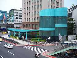
| Houshanpi Station Exit 2 | |
| Location | |
| Municipality | Taipei |
| District(s) | Nangang, Xinyi |
| Address | No. 2, Sec. 6, Zhongxiao E. Rd. |
| Info | |
| Type | Underground |
| History | |
| Opened | December 30, 2000 |
| Rail services | |
| Line(s) | Nangang Line (BL15) |
| Daily Ridership | 36,684 (2011)[1] (Ranked 31st of 89) |
| Operator(s) | Taipei Rapid Transit System |
| Houshanpi Station | |||||||||
| Traditional Chinese | 後山埤站 | ||||||||
|---|---|---|---|---|---|---|---|---|---|
| Simplified Chinese | 后山埤站 | ||||||||
| |||||||||
The Taipei Metro Houshanpi Station is a station on the Nangang Line located on the border of the Nangang and Xinyi districts, Taipei, Taiwan.[2] It opened for service on December 30, 2000, as part of an eastern extension to Kunyang.
Station overview
The station is underground and has one island platform and four exits. It is located beneath Zhongxiao East Rd.
Station layout
| L1 | Street Level | Exit/ Entrance |
| B1 | Concourse | Lobby, information desk, automatic ticket dispensing machines, one-way faregates, Restrooms(East side, outside fare zone near Exit 3 and 4) |
| B2 | Platform 1 | ← Nangang Line toward Taipei Nangang Exhibition Center (Kunyang) |
| Platform 2 | → Nangang Line toward Yongning/Far Eastern Hospital (Yongchun) → | |
Exits

Houshanpi Station Exit 1.
- Exit 1: Zhongpo N. Rd.
- Exit 2: Yucheng Park
- Exit 3: Zhongxiao Hospital

- Exit 4: Yongji Rd.
Around the station
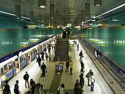
Houshanpi Station platform
- Wufenpu
- Taipei City Hospital
- Yucheng Park
- Youde High School
- Chengde Elementary School (between this station and Kunyang Station)
- Chengde Junior High School
- Yongchun Elementary School (between this station and Yongchun Station)
- Yongji Elementary School
- Raohe Street Night Market
| Preceding station | Taipei Metro | Following station | ||
|---|---|---|---|---|
toward Yongning | Blue Line Nangang Line | toward Taipei Nangang Exhibition Center |
References
| Wikimedia Commons has media related to Houshanpi Station. |
- ↑ "Passenger Volume at Taipei Rapid Transit Stations" (PDF). Taipei City Department of Transportation. 2012-01-20. Retrieved 2012-02-05.
- ↑ "Route Map: Houshanpi".
Coordinates: 25°02′42″N 121°34′56″E / 25.044864°N 121.582342°E