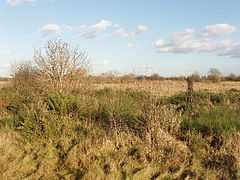
Hounslow Heath
| Hounslow Heath | |
|---|---|
 | |
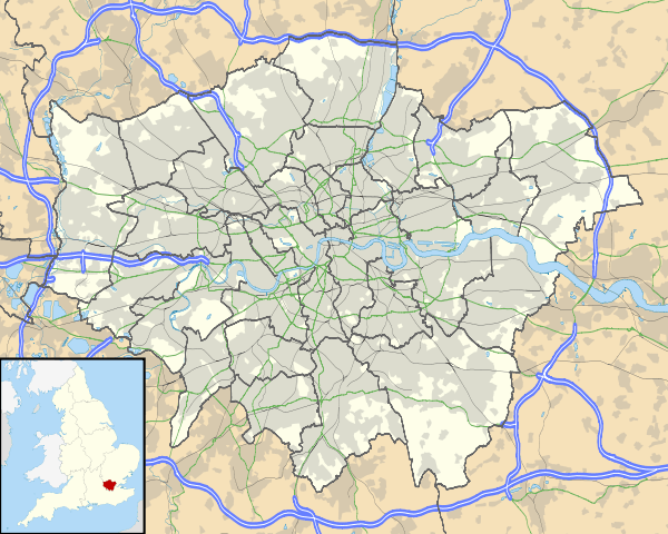 Hounslow Heath in Greater London | |
| Location | Hounslow |
| Nearest city | London |
| OS grid | TQ1274 |
| Coordinates | 51°27′17″N 0°23′6″W / 51.45472°N 0.38500°WCoordinates: 51°27′17″N 0°23′6″W / 51.45472°N 0.38500°W |
| Area | 82 hectares (200 acres) |
| Operated by | London Borough of Hounslow |
| Status | open all year |
| Hiking trails | Crane Valley Walk (London Loop) |
| Habitats | Heathland |
| Designation | Local Nature Reserve |
| Parking | A315 Staines Road |
| Public transit access |
Buses:237, 116, 117, 235 Hounslow West tube |
| Other information | Telephone: 08454562796 |
| Website | http://www.hounslow.gov.uk/parks_and_open_spaces |
Hounslow Heath is a public open space and local nature reserve in the London Borough of Hounslow. It now covers about 200 acres (80 ha), what is left of the historic Hounslow Heath that covered over 4,000 acres (1,600 ha).

History
The heathland of Hounslow Heath originally covered an area underlain by Taplow gravel that now includes parts of Bedfont, Brentford, Cranford, Feltham, Hampton, Fulwell, Hanworth, Harlington, Harmondsworth, Heston, Hounslow, Isleworth, Stanwell, Teddington, Twickenham, and Heathrow.[1]
Hounslow Heath has had major historical importance, originally crossed by main routes from London to the west and southwest of Britain. Staines Road, the northern boundary of the present heath, was the Roman Road, Via Trinobantes. There are several historic references to Roman camps on or close to the heath. Continuous recorded history dates back to Norman times. In 1546, Hounslow Heath was surveyed with a recorded area of 4,293 acres (1,737 ha) (6.71 square miles). Various armies used the heath due to its nearness to London, Windsor and Hampton Court. Oliver Cromwell stationed an army there at the end of the English Civil War in 1647. James II camped his army there, and conducted military exercises and mock battles to try to intimidate the population in London. In 1793, Hounslow Barracks was built to the north of Staines Road as part of the preparations to meet a possible French invasion. In the 17th and 18th centuries, the heath was notorious as the haunt of highwaymen and footpads, being crossed by the Great West Road and the Bath Road.[2][3][4]
The eventual mapping of the whole of the United Kingdom by the Ordnance Survey began with the measuring of an accurate base-line on Hounslow Heath, chosen for its flatness and its relative proximity to the Royal Greenwich Observatory. A sighting was made of the spire of All Saints' church in Banstead, and along that line a length of 27,400 feet was very precisely measured. This work by General William Roy was the start of the Principal Triangulation of Great Britain.
By 1900, the heath was still in use as a training ground for horse-mounted cavalry based at Hounslow Barracks, a gun shooting range, and adjacent army medical units including an isolation hospital. After the outbreak of World War I in 1914, Hounslow Heath Aerodrome was established, that developed to become a fighter aircraft defence and training base. In 1919, the aerodrome became the sole London Terminal Aerodrome, and hosted the first scheduled daily international commercial air services. In 1920, it surrendered its role to Croydon Airport, and closed. The heath was then again used for military training and a repair depot.[5]
On the south side of Staines Road, to the north of the Heath, is a monument, now in a state of neglect, commemorating the first flight to Australia, which took off from the former Hounslow Heath Aerodrome.[6] It reads:
This plaque marks the entrance to London's first civil airport
London Terminal Aerodrome Hounslow Heath
August 1919 - 1920
From here the first British international airline operation
and the first flight from Europe to Australia was made
Erected by the Heston and Isleworth Borough Council
An area to the west of the present heath was used for gravel extraction after World War II. Used for landfill until the late 1960s, the land was reclaimed to form Hounslow Heath Golf Centre which opened in 1979.[7][8]
Archaeology
Bronze Age spearheads, axes, and sword and knife fragments from Hounslow, are held at the British Museum, also Celtic badges and amulets discovered in a field at Hounslow in 1864. In 1999, excavations on the former Feltham Marshalling Yards to the south of the heath unearthed remains of an Iron Age furnace and post holes from a round house. There are various remains of former mills and other industrial archaeological features adjoining the River Crane near the heath. This part of the river is classified as an Archaeological Priority Area.[4][9]
Geography
The present Hounslow Heath is bounded by A315 Staines Road, A3063 Wellington Road South, A314 Hanworth Road, and the River Crane. The Heathland School is also behind it.
Nature reserve

Hounslow Heath is a designated local nature reserve[10][11] and Site of Metropolitan Importance for Nature Conservation,[12] and is made up of lowland heath, dry acid grassland, woodland, scrub, neutral grasslands, wetlands, wildflower meadows, providing a wild, rugged country setting with a large network of paths.[13]
See also
- Hounslow parks and open spaces
Notes
- ↑ Reynolds, Susan, ed. (1962). "Heston and Isleworth: Hounslow Heath". A History of the County of Middlesex. 3: Shepperton, Staines, Stanwell, Sunbury, Teddington, Heston and Isleworth, Twickenham, Cowley, Cranford, West Drayton, Greenford, Hanwell, Harefield and Harlington. Institute of Historical Research. pp. 94–96. Retrieved 26 November 2014.
- ↑ Lysons, Daniel (1795). Heston. The Environs of London. 3: County of Middlesex. pp. 22–45.
- ↑ Hounslow Online hounslowtw3.net
- ↑ 4.0 4.1 Maxwell, Gordon S. (1949). Highwayman's Heath: The Story in Fact and Fiction of Hounslow Heath in Middlesex. Thomasons. ISBN 1-899144-00-5.
- ↑ Sherwood, Tim (1999). Coming in to Land: A Short History of Hounslow, Hanworth and Heston Aerodromes 1911-1946. Heritage Publications. ISBN 1-899144-30-7.
- ↑ "Hounslow Heath - Hidden London". airfieldinformationexchange.org. Retrieved 18 April 2013.
- ↑ "Hounslow Heath Nature Reserve" (PDF). Green route walks in Hounslow. p. 13.
- ↑ "Hounslow Heath". London Gardens Online. Retrieved 20 November 2014.
- ↑ About The Heath hounslow.info
- ↑ "Hounslow Heath". Local Nature Reserves. Natural England. 5 March 2013. Retrieved 22 August 2013.
- ↑ "Map of Hounslow Heath". Local Nature Reserves. Natural England. Retrieved 22 August 2013.
- ↑ "Hounslow Heath". Greenspace Information for Greater London. 2013. Retrieved 22 August 2013.
- ↑ Hounslow Parks & Open Spaces hounslow.info
External links
| Wikimedia Commons has media related to Hounslow Heath. |
| ||||||||||||||||||||||||||||||||||||||||||||||||||||||||||||||||||||||||||||||||||||||||||||||||||||||||||||||||||||||||||