Horse Holm
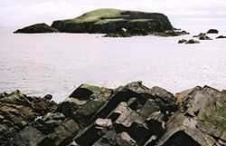
Horse Holm from Hog of Ness
The Horse Holm (grid reference HU 384 074), referred to on maps[1] as Horse Island, known to locals simply as Da Holm, and used as an alignment point by local fishermen for several fishing marks, lies about 2.3 km west of Sumburgh Head at the south tip of the Mainland, Shetland.
Footnotes
- ↑ incl. Ordnance Survey maps, Admiralty charts, maps and documents of international marine and hydrographic services like International Hydrographic Organization
This article incorporates text from Shetlopedia
Coordinates: 59°51′00″N 1°18′59″W / 59.85002°N 1.31645°W