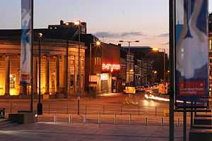
Hope Street, Liverpool

Hope Street, Liverpool, England stretches from the city's Roman Catholic cathedral, past the Anglican cathedral to Upper Parliament Street and it is the local high street of the Canning Georgian Quarter.[1] It contains various restaurants, hotels and bars and is one of Liverpool's official 'Great Streets' [2] and was also awarded 'The Great Street Award' in the 2012 Urbanism Awards,[3] judging it to be the best street in the country. The road runs parallel to Rodney Street (the Harley Street of the north). Together with Gambier Terrace and Rodney Street it forms the Rodney Street conservation area. The years immediately after the Millennium saw the public realm of Hope Street enhanced and the Hope Street area has sometimes been referred to as the Hope Street Quarter.
The street is named after William Hope, a merchant whose house stood on the site now occupied by the Philharmonic Hall.
Hope Street was voted as the best street in the UK and Ireland by The Academy of Urbanism, who awarded it The Great Street 2013.
History
Hope Street was straightened during the 1790s and residential construction commenced around the turn of the century. The Liverpool Philharmonic Hall (home of the Royal Liverpool Philharmonic Society) stands on the corner of Myrtle Street and Hope Street. It was designed by Herbert James Rowse and built between 1936 and 1939. This replaced the original building built 90 years earlier to designs by John Cunningham that burned down in 1933. It is built of brick and is starkly cubic in appearance except for a pair of rounded stair-towers to the front. The first floor windows and main entrance doors have etched glass by Hector Whistler. On Hope Street at the top of Mount Street (where stands LIPA and the former Liverpool Institute for Boys) is the interesting sculpture "A Case History" by John King, 1998. Various items of luggage, cast in concrete, are stacked on the pavement – the labels on the suitcases refer to notable individuals and institutions linked with the local area. Facing the Anglican Cathedral on Hope Street is Gambier Terrace of which numbers 2-10 were built between 1832 and 1837 by the developer Ambrose Lace, to a design in ashlar ad stucco often attributed to John Foster Jr. The terrace was extended between the late 1830s and early 1840s. At the northern end of Hope Street is the Roman Catholic Metropolitan Cathedral and, towards the southern end, the Anglican Cathedral.[4][5]
Notable buildings and places of interest
- Liverpool Metropolitan Cathedral
- Liverpool Medical Institution
- Liverpool Masonic Hall [6]
- Everyman Theatre
- Casa bar and bistro, Hope Street
- Philharmonic a Grade II* listed pub
- Liverpool Philharmonic Hall
- Hope Street Hotel[7]
- Belvedere Arms, a Grade II listed pub on Sugnall Street [8]
- Unity Theatre, Hope Place
- Ye Cracke, Rice Street
- Sheppard-Worlock Statue
- 60 Hope Street a restaurant in the former Chauffeurs Club[9]
- Blackburne House
- Liverpool Institute for Performing Arts (LIPA), Mount Street
- Liverpool College of Art
- Liverpool Cathedral
- Frederiks[10]
- St James Mount and Gardens
- Gambier Terrace, running along Hope Street
References
- ↑ Liverpool City Centre Strategic Investment Framework 2012, page 100
- ↑ Liverpool City Centre Strategic Investment Framework 2012, page 82
- ↑ "Urbanism Award for Hope Street". 2012.
- ↑ Buildings of Liverpool. Liverpool Heritage Bureau, 1978.
- ↑ Pevsner Architectural Guides - Liverpool. Joseph Sharples, 2004.
- ↑ Merchants Lodge of Hope Street Liverpool
- ↑ Hopestreet Hotel
- ↑ Merseyworld
- ↑ MyLiverpool review
- ↑ Frederiks Bar
External links
- Multi map
- Hope Street Feast - the annual street festival of the Hope Street Quarter held in September
- Rodney Street
- Hope Street Quarter
- The Hope Street Association
- a history of the Hope Street Festivals 1996-2006
- Hope Street Festivals 1977 - 1994, including HM the Queen's Silver Jubilee visit
- Maghull Group, list of Hope St properties
- Liverpool's Hope Street 'Suitcases': A Case History
| Wikimedia Commons has media related to Hope Street, Liverpool. |
Coordinates: 53°24′09″N 2°58′11″W / 53.40257°N 2.96985°W
| ||||||