Honshu
| Native name: <span class="nickname" ">本州 | |
|---|---|
 Honshu | |
 Honshu (Japan) | |
| Geography | |
| Location | East Asia |
| Archipelago | Japanese archipelago |
| Area | 227,962.59 km2 (88,016.85 sq mi) |
| Area rank | 7th |
| Length | 1,300 km (810 mi) |
| Width | 50–230 km (31–143 mi) |
| Coastline | 5,450 km (3,386 mi) |
| Highest elevation | 3,776 m (12,388 ft) |
| Highest point | Mount Fuji |
| Country | |
|
Japan | |
| Prefectures | Aomori, Iwate, Miyagi, Akita, Yamagata, Fukushima, Ibaraki, Tochigi, Gunma, Saitama, Chiba, Tokyo, Kanagawa, Niigata, Toyama, Ishikawa, Fukui, Yamanashi, Nagano, Gifu, Shizuoka, Aichi, Mie, Shiga, Kyoto, Osaka, Hyōgo, Nara, Wakayama, Tottori, Shimane, Okayama, Hiroshima, Yamaguchi. |
| Largest settlement | Tokyo (pop. 12,570,000) |
| Demographics | |
| Population | 103,000,000 (as of 2005 Census) |
| Density | 447 /km2 (1,158 /sq mi) |
| Ethnic groups | Japanese |
Honshu (本州 Honshū, literally "Main Island" or "Main Province") ([hoɴꜜɕuː]) is the largest and most populous island of Japan.[1] The nation's main island, it is south of Hokkaido across the Tsugaru Strait, north of Shikoku across the Inland Sea, and northeast of Kyushu across the Kanmon Straits. It is the seventh largest island in the world, and the second most populous after Java.[2][3]
It had a population of 103 million in 2005, mostly concentrated in the available lowlands, notably in the Kantō plain where 25% of the total population reside in the Greater Tokyo Area, which includes Tokyo and Yokohama, Kawasaki, Saitama and Chiba cities. Most of the nation's industry is located along the belt running from Tokyo along Honshu's southern coastal cities, including Kyoto, Osaka, Nagoya, Kobe, and Hiroshima, part of the Taiheiyō Belt.
The economy along the northwestern coast by the Sea of Japan is largely based on fishing and agriculture;[4] Niigata is noted as an important producer of rice. The Kantō and Nōbi plains produce rice and vegetables. Yamanashi is a major fruit-growing area, and Aomori is famous for its apples.
Eminent historical centers include Kyoto, Nara, and Kamakura.
Geography
The island is roughly 1,300 kilometres (810 mi) long and ranges from 50 to 230 km (31 to 143 mi) wide, and its total area is 227,962.59 km2 (88,016.85 sq mi), 60% of the total area of Japan. It is slightly larger than Great Britain.[5] Its area has been expanding with land reclamation and coastal uplift in the north, but global sea level rise has diminished these effects. Honshu has 5,450 kilometres (3,386 mi) of coastline.[6]
Mountainous and volcanic, Honshu has frequent earthquakes (the Great Kantō earthquake heavily damaged Tokyo in September 1923, and the earthquake of March 2011 moved the northeastern part of the island by varying amounts of as much as 5.3 m (17 ft)[7][8] (while causing devastating tsunamis); the highest peak is the active volcano Mount Fuji at 3,776 m (12,388 ft), which makes it the world's 7th highest island. There are many rivers, including the Shinano River, Japan's longest. The climate is temperate, but has marked difference between the eastern or southern (Pacific or Inland Sea coast) side, and the western or northern (Sea of Japan coast) side. A mountain range runs along the length of Honshu from end to end. In addition to Mt. Fuji, the Japanese Alps are a feature of Honshu.
Honshu is connected to the islands of Hokkaido, Kyushu and Shikoku by tunnels or bridges. Three bridge systems have been built across the islands of the Inland Sea between Honshu and Shikoku (Akashi Kaikyō Bridge and the Ōnaruto Bridge; Shin-Onomichi Bridge, Innoshima Bridge, Ikuchi Bridge, Tatara Bridge, Ōmishima Bridge, Hakata–Ōshima Bridge, and the Kurushima-Kaikyō Bridge; Shimotsui-Seto Bridge, Hitsuishijima Bridge, Iwakurojima Bridge, Yoshima Bridge, Kita Bisan-Seto Bridge, and the Minami Bisan-Seto Bridge), the Seikan Tunnel connects Honshu with Hokkaido, and the Kanmonkyo Bridge and Kanmon Tunnel connects Honshu with Kyushu.
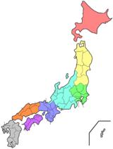
Regions and prefectures
The island is nominally divided into five regions and contains 34 prefectures, including metropolitan Tokyo. The regions are Chūgoku (western), Kansai (southern, east of Chūgoku), Chūbu (central), Kantō (eastern), and Tōhoku (northern). Some smaller islands are included within these prefectures, prominently including Ogasawara Islands, Sado Island, Izu Ōshima, and Awaji Island.
The prefectures are:
- Tōhoku — Aomori Prefecture, Iwate Prefecture, Miyagi Prefecture, Akita Prefecture, Yamagata Prefecture, Fukushima Prefecture.
- Kantō — Ibaraki Prefecture, Tochigi Prefecture, Gunma Prefecture, Saitama Prefecture, Chiba Prefecture, Tokyo, Kanagawa Prefecture.
- Chūbu — Niigata Prefecture, Toyama Prefecture, Ishikawa Prefecture, Fukui Prefecture, Yamanashi Prefecture, Nagano Prefecture, Gifu Prefecture, Shizuoka Prefecture, Aichi Prefecture.
- Kansai — Mie Prefecture, Shiga Prefecture, Kyoto Prefecture, Osaka Prefecture, Hyōgo Prefecture, Nara Prefecture, Wakayama Prefecture.
- Chūgoku region — Tottori Prefecture, Shimane Prefecture, Okayama Prefecture, Hiroshima Prefecture, Yamaguchi Prefecture.
Extreme points
The northernmost point on Honshu is the tip of the Shimokita Peninsula in Ōma, Aomori. Cape Kure lies at the southern extreme in Kushimoto, Wakayama. The island is bounded on the east by Todogasaki in Miyako, Iwate and on the west by Bishanohana in Shimonoseki, Yamaguchi. It spans more than eight degrees of latitude and 11 degrees of longitude.
Natural features
Minerals
Yields of zinc, copper, and oil have been found on Honshu.[9]
Agriculture
Most of Japan's tea and silk is from Honshu. Fruits, vegetables, grains, rice and cotton are grown in Honshu.[9]
References
- ↑ Honshu
- ↑ Japan Civil Registry Database 2013
- ↑ See Japan Census of 2000; The editors of List of islands by population appear to have used similar data from the relevant statistics bureaux, and totalled up the various administrative districts that make up each island, and then done the same for less populous islands. An editor of this article has not repeated that work. Therefore this plausible and eminently reasonable ranking is posted as unsourced common knowledge.
- ↑ Kodansha Encyclopedia of Japan
- ↑ "Islands by land area". UN SYSTEM-WIDE EARTHWATCH. Retrieved 17 July 2013.
- ↑ "Honshu". Encyclopædia Britannica Online. Retrieved 22 February 2013.
- ↑ "Map of Horizontal Land Movement caused by 2011/3/11 M9.0 earthquake" (PDF) (in Japanese). Geospatial Information Authority of Japan. March 19, 2011. Retrieved 15 November 2012.
- ↑ "Quake shifted Japan by over two meters". Deutsche Welle. March 14, 2011. Retrieved March 14, 2011.
- ↑ 9.0 9.1 "Honshu". infoplease.com. 2012. Retrieved 2014-11-23.
External links
| Wikimedia Commons has media related to Honshu. |
| ||||||||||||||||||||||||||||||||||||||||||||||