Honnavar
| Honnavar ಹೊನ್ನಾವರ | |
|---|---|
| Town | |
 Honnavar | |
| Coordinates: 14°16′48″N 74°26′38″E / 14.28°N 74.4439°ECoordinates: 14°16′48″N 74°26′38″E / 14.28°N 74.4439°E | |
| Country |
|
| State | Karnataka |
| Region | Canara |
| District | Uttara Kannada |
| Taluk | Honnavar |
| Established | 1890[1] |
| Government | |
| • Type | Municipality |
| • Body | Honnavar Town Panchayat |
| Area | |
| • Total | 9.38 km2 (3.62 sq mi) |
| Elevation | 2 m (7 ft) |
| Population (2011) | |
| • Total | 19,109[2] |
| Languages | |
| • Official | Kannada |
| Time zone | IST (UTC+5:30) |
| PIN | 581334, 581395, 581342 |
| Telephone code | +91-8387 |
| Vehicle registration | KA 47 |
| Website | www.honnavaratown.gov.in |
Honavar or Honnavar is a port town in Uttara Kannada district of Karnataka, India. The town is the headquarters of Honnavar Taluk.
History
In the 10th century text Jain Ramayana, the town is mentioned as Hanuruha Island. References about the town are also available in the works of Abu al-Fida (AD 1273-1331), an Arab geographer as well as that of Ibn Batuta who described it as the city of Hinaur.
Honnavar or Onore was a notable seaport of British India, in the Uttara Kannada or North Canara district of Karnataka. It is mentioned as a place of trade as early as the 16th century.
Geography
Honnavar town has Arabian Sea to the west and river Sharavati to the south, forming an estuary. The town lies midway between Panaji and Mangalore. Some of the places with tourism interest around Honavar include Murudeshwar, Idagunji, Apsarkonda, Gerusoppa and Karikanamma.
Honnavar has a port that was one of the most important ones on the west coast of India during the time of Marco Polo.
Between the 11th and 14th century AD Honnavar was under the rule of the Kadambas of Chandavar. When Traveller Ibn Battuta visited this city in 1342-1345 this port city was ruled by Sultan Jamaluddin Muhammad bin Hasan.[3] Honnavar became a trading centre during the time of Vijayanagar Empire. Horses from Portugal were imported through this port. The well-known Vijayanagar King Krishnadevaraya gave permission to the Portuguese to construct forts at Honnavar and Bhatkal.
Attractions
Sharavati River is one of the main attractions of Honnavar. The river joins the Arabian Sea at Honnavar. While joining the sea, the river has created some islands.
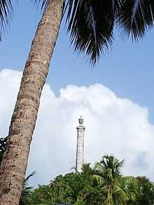
Colonel Hill is an place of interest in Honnavar. It is a 30-meter tall column on the top of a hillock by the side of N-H 17. This column was installed in memory of Colonel Hill on 20 January 1845. It was set up by the 14th Madras Native Infantry at the instance of the East India Company in honour of Col. Hill who died at Gersoppa while commanding the Mysore Division.

Kasarkod beach is a tourist attraction of Honnavar. It is about 2 km from Honnavar. This beautiful sandy beach is about 5 km long. The waves, golden sand top and the enchanting scenic beauty attract thousands of tourists every day.
Basavaraja Durga is a fortified spot is an 19 hectare island in the Arabian Sea. It is 3 km from the Sharavathi Sea Mouth and can be reached by boat. The fort was constructed during the Vijayanagara rule. In 1690, the Keladi ruler Shivappa Nayak captured it and named it Basavarajadurga in memory of the Keladi Prince Basavaraja.
Venkatarama Temple is a temple famous for its annual Rath Yatra on the occasion of Ramnavami. The event attracts thousands from all the neighbouring towns and villages.
Transportation
Rail
Konkan Railway line passes through Honnavar and has a station at Karki, which is about 5 km from the centre of the town. Konkan Railway's longest bridge is 2.065 km in length and is in Honnavar over Sharavati River.[4]
There is also a proposal to connect Honnavar and Talguppa in Shimoga district by a new railway line, which will be a shorter alternate rail route between Mumbai and southern India. In Railway Budget 2010-11, Indian Railway Ministry suggested Public–private partnership (PPP) model to take up this project as the Government of India cannot fund this project alone due to concerns about Rate of return and the complex nature of the project.
Sea
In October 2013 the Karnataka government announced plans to develop a new port at Honnavar, to be funded by a public–private partnership (PPP) model.[5]
Inland Water
The Government of Karnataka has been working on improving the Inland Water Transportation system between Honnavar and Gerusoppa along Sharavati river coast.[6] Also, the Office of Ferries Inspector (Mangalore Circle) that oversees Inland Water Transportation System of the entire coastal belt of Karnataka State is headquartered at Honnavar.[7]
Air
The nearest airport is Mangalore International Airport.
References
- ↑ "Basic City Statistics" (PDF). honnavaratown.gov.in.
- ↑ "Honnavar Town Panchayath". Government of Karnataka. Retrieved 26 October 2014.
- ↑ Ibn Battuta, Rihalat Ibn Battuta, Maktaba al-Tijariyya al-Kubra, Egypt, 1958, vol. 2, p. 110
- ↑ http://www.konkanrailway.com/node/120
- ↑ "Karnataka plans new port at Honnavar for Rs 600 crore". Bangalore: Business Standard. 10 October 2013. Retrieved 23 November 2013.
- ↑ http://www.karnatakaports.in/ongoing_projects.htm
- ↑ http://www.karnatakaports.in/organization.htm
| Wikimedia Commons has media related to Honnavara. |
External links
| ||||||||||||||