Homeworth, Ohio
| Homeworth, Ohio | |
|---|---|
| Census-designated place | |
 Homeworth | |
| Coordinates: 40°50′7″N 81°4′2″W / 40.83528°N 81.06722°WCoordinates: 40°50′7″N 81°4′2″W / 40.83528°N 81.06722°W | |
| Country | United States |
| State | Ohio |
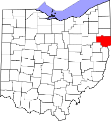
| County | Columbiana |
| Township | Knox |
| Area | |
| • Total | 1.25 sq mi (3.25 km2) |
| • Land | 1.24 sq mi (3.21 km2) |
| • Water | 0.02 sq mi (0.04 km2) |
| Elevation[1] | 1,140 ft (350 m) |
| Population (2010) | |
| • Total | 481 |
| • Density | 388/sq mi (149.9/km2) |
| Time zone | Eastern (EST) (UTC-5) |
| • Summer (DST) | EDT (UTC-4) |
| ZIP code | 44634 |
| Area code(s) | 330, 234 |
| FIPS code | 39-36176[2] |
| GNIS feature ID | 1064857[1] |
Homeworth is a census-designated place in Knox Township, Columbiana County, Ohio, United States.[3] The population was 481 as of the 2010 census.[4]
Settlement began at what is now Homeworth about 1840. The town of Homeworth had its start in the year 1851 by the building of the Cleveland and Pittsburgh Railroad through that territory.[5]
Its elevation is 1,155 feet (352 m) above sea level. Its ZIP code is 44634.
Geography
Homeworth is located in northwestern Columbiana County, in the southwestern part of Knox Township. It is located in the valley of Middle Sandy Creek near its headwaters. The city of Alliance is 7 miles (11 km) to the northwest. Salem is 12 miles (19 km) to the northeast, and Canton is 18 miles (29 km) to the west.
According to the U.S. Census Bureau, the Homeworth CDP has a total area of 1.25 square miles (3.25 km2), of which 1.24 square miles (3.21 km2) is land and 0.02 square miles (0.04 km2), or 1.18%, is water.[4]
Notable residents
- Wesley Matthias Stanford (b. 1846), bishop of the United Evangelical Church
References
- ↑ 1.0 1.1 "US Board on Geographic Names". United States Geological Survey. 2007-10-25. Retrieved 2008-01-31.
- ↑ "American FactFinder". United States Census Bureau. Retrieved 2008-01-31.
- ↑ U.S. Geological Survey Geographic Names Information System: Homeworth, Ohio
- ↑ 4.0 4.1 "Geographic Identifiers: 2010 Demographic Profile Data (G001): Homeworth CDP, Ohio". U.S. Census Bureau, American Factfinder. Retrieved January 23, 2015.
- ↑ McCord, William B. (1905). History of Columbiana County, Ohio and Representative Citizens. Biographical Publishing Company. p. 284.
| |||||||||||||||||||||||||||||||||