Holtedahl Bay
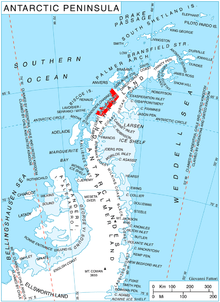
Holtedahl Bay (66°7′S 65°20′W / 66.117°S 65.333°WCoordinates: 66°7′S 65°20′W / 66.117°S 65.333°W) is a bay, 10 nautical miles (19 km) long in a northwest–southeast direction and averaging 6 nautical miles (11 km) wide, between Velingrad Peninsula and Stresher Peninsula along the west coast of Graham Land, Antarctica. Entered southwest of Prospect Point and northeast of Black Head. It was discovered by the British Graham Land Expedition, 1934–37, and named by John Rymill for Professor Olaf Holtedahl, a Norwegian geologist who conducted geologic research during 1927–28 in the South Shetland Islands and the Palmer Archipelago, to which he was transported by various whaling vessels.[1]
References
- ↑ "Holtedahl Bay". Geographic Names Information System. United States Geological Survey. Retrieved 2012-06-22.
![]() This article incorporates public domain material from the United States Geological Survey document "Holtedahl Bay" (content from the Geographic Names Information System).
This article incorporates public domain material from the United States Geological Survey document "Holtedahl Bay" (content from the Geographic Names Information System).