Hoher Göll
| Hoher Göll | |
|---|---|
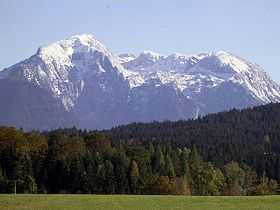 Göll massif from the west, Hoher Göll peak on the left | |
| Elevation | 2,522 m (8,274 ft) |
| Location | |
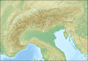 Hoher Göll Location in the Alps | |
| Location |
Bavaria, Germany Salzburg, Austria |
| Range | Berchtesgaden Alps |
| Coordinates | 47°35′39″N 13°4′1″E / 47.59417°N 13.06694°ECoordinates: 47°35′39″N 13°4′1″E / 47.59417°N 13.06694°E |
| Climbing | |
| First ascent | 4 September 1800 by Valentin Stanič |
Hoher Göll is a 2,522 m (8,274 ft) mountain in the Berchtesgaden Alps, the highest peak of the Göll massif, which straddles the border between the German state of Bavaria and Salzburg, Austria.
Geography

Rising above Obersalzberg near Berchtesgaden, the massif is situated between the Königssee and the Königsseer Ache in the west, opposite the Watzmann, and the Salzach Valley of the Tennengau region in the east. Neighbouring peaks include Hohes Brett, Jenner and the Kehlstein spur with the famous Kehlsteinhaus, linked with the Hoher Göll via the Mannlgrat ridge.
Climbing
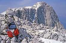
The first documented ascent was made by the ordinand Valentin Stanič from Bodrež in Gorizia and Gradisca, who at that time studied theology at the nearby University of Salzburg and had also climbed the Watzmann peak.
A wide variety of routes lead to its summit, ranging from UIAA Grade I on a Klettersteig up the Mannlgrat ridge[1] to UIAA Grade VIII up the West face.[2] The Kehlsteinhaus is located on the German side, at 1,834 m (6,034'). A trail leads from it to the Mannlgrat, the easiest route to the top.
Another propular round-trip ascent of the Hoher Göll is from the Purtschellerhaus mountain hut up to the summit and down to Stahl-Haus.[3]