Hohenau an der March
| Hohenau an der March | ||
|---|---|---|
| ||
 Hohenau an der March Location within Austria | ||
| Coordinates: 48°36′N 16°54′E / 48.600°N 16.900°ECoordinates: 48°36′N 16°54′E / 48.600°N 16.900°E | ||
| Country | Austria | |
| State | Lower Austria | |
| District | Gänserndorf | |
| Government | ||
| • Mayor | Robert Freitag | |
| Area | ||
| • Total | 23.37 km2 (9.02 sq mi) | |
| Elevation | 155 m (509 ft) | |
| Population (1 January 2014)[1] | ||
| • Total | 2,705 | |
| • Density | 120/km2 (300/sq mi) | |
| Time zone | CET (UTC+1) | |
| • Summer (DST) | CEST (UTC+2) | |
| Postal code | 2273 | |
| Area code | 02535 | |
| Website | www.hohenau-march.at | |
Hohenau an der March (Czech: Cáhnov, Slovak: Cahnov) is a town in the district of Gänserndorf in the Austrian state of Lower Austria, close to Vienna and the borders with the Czech Republic and Slovakia.
Geography
The town lies on the river Morava (March in German). It lies in the Weinviertel in Lower Austria. Only about 6.18 percent of the municipality is forested.
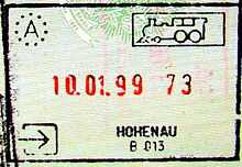
Passport stamp from the Austrian-Czech railway border before Czech Republic joined the European Union.