Hohen Neuendorf
| Hohen Neuendorf | ||
|---|---|---|
|
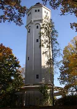
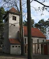
Water tower | ||
| ||
 Hohen Neuendorf | ||
Location of Hohen Neuendorf within Oberhavel district 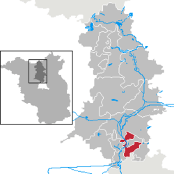 | ||
| Coordinates: 52°40′N 13°17′E / 52.667°N 13.283°ECoordinates: 52°40′N 13°17′E / 52.667°N 13.283°E | ||
| Country | Germany | |
| State | Brandenburg | |
| District | Oberhavel | |
| Government | ||
| • Mayor | Klaus-Dieter Hartung (Left) | |
| Area | ||
| • Total | 48.06 km2 (18.56 sq mi) | |
| Population (2012-12-31)[1] | ||
| • Total | 24,905 | |
| • Density | 520/km2 (1,300/sq mi) | |
| Time zone | CET/CEST (UTC+1/+2) | |
| Postal codes | 16540, 16556, 16562 | |
| Dialling codes | 03303 | |
| Vehicle registration | OHV | |
| Website | www.hohen-neuendorf.de | |

Hohen Neuendorf is a town in the Oberhavel district, in Brandenburg, Germany. It is located north west of Berlin.
Geography
Hohen Neuendorf is situated upon the Havel river (built on the Oder-Havel Canal) and is bordered by the Berlin area Frohnau to the south, Muehlenbeck (including Schoenfliess) to the east, Birkenwerder and Oranienburg to the north, and Hennigsdorf and Velten to the west.
Division of the town
Hohen Neuendorf consists of 4 districts (with area codes):
- Hohen Neuendorf (area code: 16540)
- Stolpe (area code: 16540)
- Borgsdorf and its east side Pinnow (area code: 16556)
- Bergfelde (area code: 16562)
Demography
-
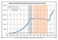
Development of Population since 1875 within the Current Boundaries (Blue Line: Population; Dotted Line: Comparison to Population Development of Brandenburg state; Grey Background: Time of Nazi rule; Red Background: Time of Communist rule)
-
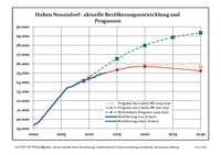
Recent Population Development (Blue Line) and Forecasts
|
|
|
|
Detailed data sources are to be found in the Wikimedia Commons.[3]
History
Since the suburban move of Berlin which ended in the late 19th century, allowed by the development of the train, Hohen Neuendorf was a little town with few residents.
The creation of a train station in Hohen Neuendorf on the North Train from Berlin in the last quarter of the 19th century, thanks to the larger, richer nearby village of Stolpe, led to a speedy development of Hohen Neuendorf paralleled to that occurring in Berlin. With the rising role of Hohen Neuendorf as a commuter village across from Stolpe (which stayed largely agricultural in nature), it was finally with the (mis)placement of the train stop that emphasis on the settlement of Hohen Neuendorf ensued. The new Hohen Neuendorf station today is frequented by the users of Berlin's "S-Bahn" ("Schnell-Bahn", lit. fast train), while the old station's building has now been made into a hotel.
West Berlin border crossing
The municipality shared its borders with the former West Berlin, and so during the period 1961-1990 it was separated from it by the Berlin Wall. Between 1 January 1988 and 30 June 1990 Hohen Neuendorf's component village of Stolpe served as East German border crossing for cars travelling between West Berlin and the East German Democratic Republic) or the West German Federal Republic of Germany. The traffic was subject to the Interzonal traffic regulations, that between West Germany and West Berlin followed the special regulations of the Transit Agreement (1972). After 9 November 1989 eastern controls were gradually eased into spot checks and finally abolished on 30 June 1990, the day East and West introduced the union concerning currency, economy and social safety (German: Währungs-, Wirtschafts- und Sozialunion).
International relations
Hohen Neuendorf is twinned with:
-
 Janów Podlaski (Poland)
 -
 Maing (France)
 -
 Müllheim (Baden-Württemberg, Germany)
 - Fürstenau (Lower Saxony, Germany)
Sport
The RU Hohen Neuendorf, a rugby union club, competes at the second tier of German club rugby, the 2nd Rugby-Bundesliga North/East, having earned promotion to the league in 2008.
See also
- Hohen Neuendorf railway station
References
- ↑ "Bevölkerung im Land Brandenburg nach amtsfreien Gemeinden, Ämtern und Gemeinden 31. Dezember 2012 (XLS-Datei; 83 KB) (Einwohnerzahlen auf Grundlage des Zensus 2011)". Amt für Statistik Berlin-Brandenburg (in German). 31 December 2012.
- ↑ Boundaries as of 2013
- ↑ Population Projection Brandenburg at Wikimedia Commons
External links
- Official site (German)
![]() This article incorporates text from a publication now in the public domain: Chisholm, Hugh, ed. (1911). Encyclopædia Britannica (11th ed.). Cambridge University Press.
This article incorporates text from a publication now in the public domain: Chisholm, Hugh, ed. (1911). Encyclopædia Britannica (11th ed.). Cambridge University Press.
| ||||||||